Property Record
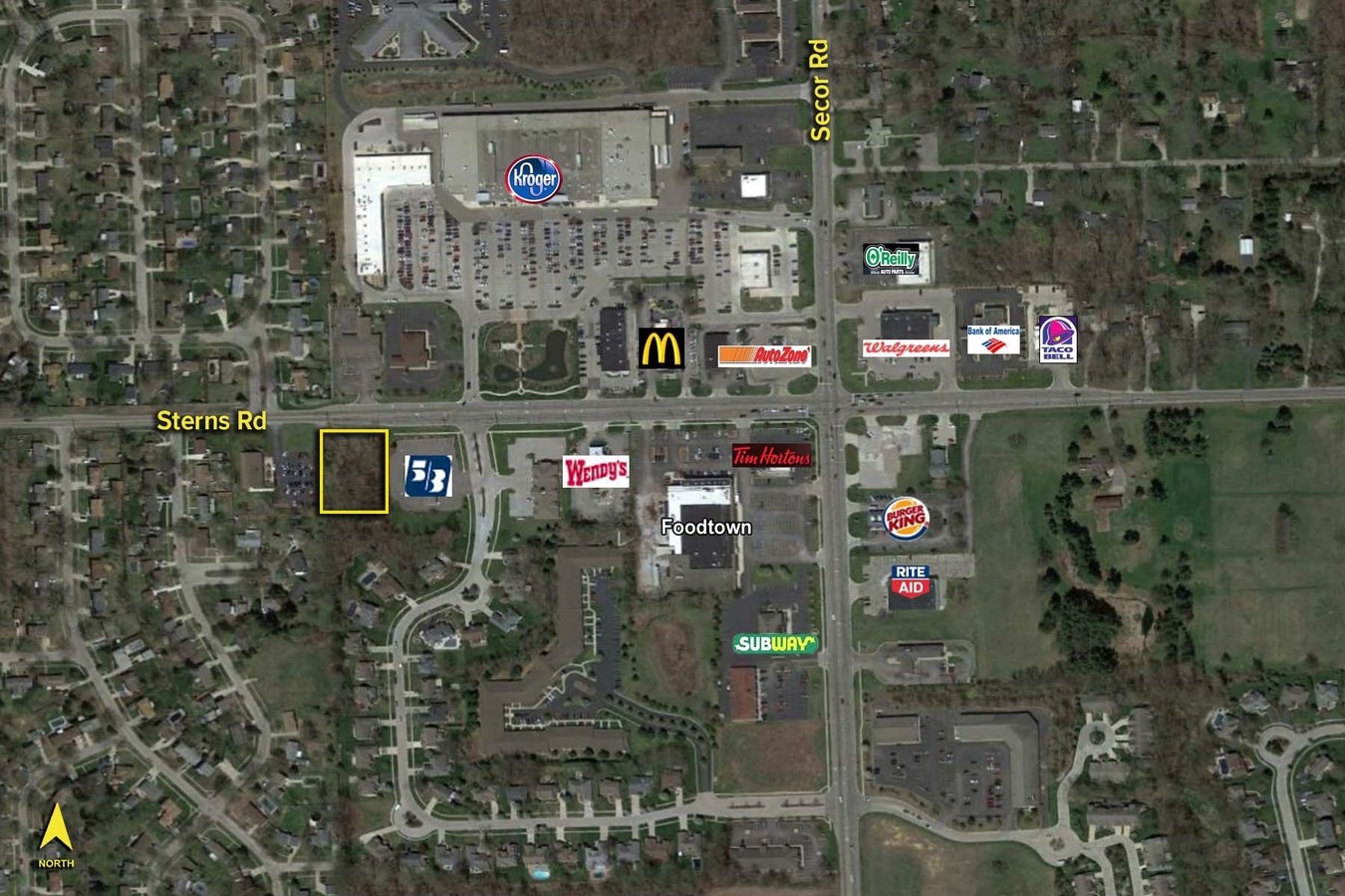
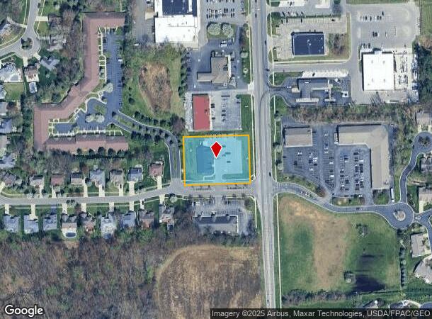
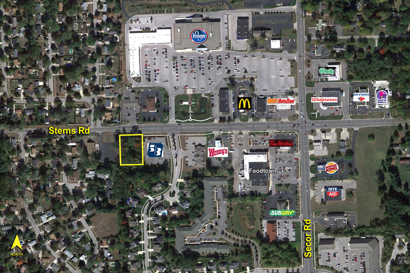
7301 Secor Rd, Lambertville, MI 48144

NEARBY LISTINGS FOR SALE OR LEASE
Property Detail
7301 Secor Rd
Monroe, MI
Quail Hollow
02-491-025-00
LOT 25, VILLAGE OF QUAIL HOLLOW, ACCORDING TO THE PLAT THEREOF, AS RECORDED IN TIBER 17 OF PLATS, PA
Commercialnec
Monroe
X
Michigan
39095C0057F
25
2024
1.22 AC
2024
Monroe County
833300
Detroit
DEMOGRAPHICS near 7301 Secor Rd
1 Mile
3 Mile
5 Mile
2024 Total Population
5,330
46,848
126,641
2029 Population
5,335
46,443
124,952
Pop Growth 2024-2029
+ 0.09%
(0.86%)
(1.33%)
Average Age
45
42
41
2024 Total Households
2,168
19,705
54,204
HH Growth 2024-2029
+ 0.05%
(0.91%)
(1.39%)
Median Household Inc
$95,774
$68,965
$62,797
Avg Household Size
2.40
2.30
2.30
2024 Avg HH Vehicles
2.00
2.00
2.00
Median Home Value
$230,892
$172,714
$153,987
Median Year Built
1983
1968
1961
Nearby Places
- Restaurants
- Banks
- Shops
- Fitness
- Groceries
PUBLIC TRANSPORTATION
AIRPORT
Eugene F Kranz Toledo Express
DRIVE
WALK
Distance
Eugene F Kranz Toledo Express
40 min
24.0 mi
Freight Ports
Port of Toledo
DRIVE
WALK
Distance
Port of Toledo
30 min
15.4 mi
SALE & LEASE HISTORY
LISTING DATE
SALE/LEASE

Sep 24, 2016
For Sale
Nearby Properties
Address
Land Use
TOTAL SIZE
Lot Size
Zoning
Address
Land Use
TOTAL SIZE
Lot Size
Zoning
76.32 AC
10-IG
Address
Land Use
TOTAL SIZE
Lot Size
Zoning
165,739 SF
17.77 AC
Address
Land Use
TOTAL SIZE
Lot Size
Zoning
223,900 SF
17.26 AC
Address
Land Use
TOTAL SIZE
Lot Size
Zoning
293,770 SF
13.95 AC
10-RS6
Address
Land Use
TOTAL SIZE
Lot Size
Zoning
43,616 SF
11.83 AC
10-RS6
Address
Land Use
TOTAL SIZE
Lot Size
Zoning
6.58 AC
Address
Land Use
TOTAL SIZE
Lot Size
Zoning
6.50 AC
Address
Land Use
TOTAL SIZE
Lot Size
Zoning
222,493 SF
29.88 AC
10-IC
Address
Land Use
TOTAL SIZE
Lot Size
Zoning
170,528 SF
15 AC
Address
Land Use
TOTAL SIZE
Lot Size
Zoning
41,200 SF
9.45 AC
31-MX
Address
Land Use
TOTAL SIZE
Lot Size
Zoning
67,977 SF
5.82 AC
Address
Land Use
TOTAL SIZE
Lot Size
Zoning
49,865 SF
3.97 AC
Address
Land Use
TOTAL SIZE
Lot Size
Zoning
3.72 AC
Address
Land Use
TOTAL SIZE
Lot Size
Zoning
99,366 SF
1.57 AC
10-RS12
Address
Land Use
TOTAL SIZE
Lot Size
Zoning
5.31 AC
Address
Land Use
TOTAL SIZE
Lot Size
Zoning
53,933 SF
5.26 AC
Address
Land Use
TOTAL SIZE
Lot Size
Zoning
141,196 SF
7.40 AC
10-RM36
Address
Land Use
TOTAL SIZE
Lot Size
Zoning
124,772 SF
4.22 AC
10-IC
Address
Land Use
TOTAL SIZE
Lot Size
Zoning
97,790 SF
5 AC
10-RM36
Address
Land Use
TOTAL SIZE
Lot Size
Zoning
30,108 SF
4.43 AC
Address
Land Use
TOTAL SIZE
Lot Size
Zoning
7,174 SF
98.54 AC
Address
Land Use
TOTAL SIZE
Lot Size
Zoning
34,634 SF
37.38 AC
B2
Address
Land Use
TOTAL SIZE
Lot Size
Zoning
71,463 SF
9.05 AC
10-MX
Address
Land Use
TOTAL SIZE
Lot Size
Zoning
42,066 SF
7.26 AC
10-MX
Address
Land Use
TOTAL SIZE
Lot Size
Zoning
125,354 SF
4.14 AC
10-CR
Address
Land Use
TOTAL SIZE
Lot Size
Zoning
54,786 SF
7 AC
10-RS6
Address
Land Use
TOTAL SIZE
Lot Size
Zoning
41,660 SF
1.63 AC
20-R4
Address
Land Use
TOTAL SIZE
Lot Size
Zoning
6,420 SF
2.12 AC
Address
Land Use
TOTAL SIZE
Lot Size
Zoning
53,246 SF
7 AC
10-RS6
Address
Land Use
TOTAL SIZE
Lot Size
Zoning
58,048 SF
2 AC
10-CR
The World's #1 Commercial Real Estate Marketplace
Connect with us
© 2025 CoStar Group
The information above has been obtained from sources believed reliable. While we do not doubt its accuracy we have not verified it and make no guarantee, warranty or representation about it. It is your responsibility to independently confirm its accuracy and completeness. Any projections, opinions, assumptions, or estimates used are for example only and do not represent the current or future performance of the property. The value of this transaction to you depends on tax and other factors which should be evaluated by your tax, financial, and legal advisors. You and your advisors should conduct a careful, independent investigation of the property to determine to your satisfaction the suitability of the property for your needs.