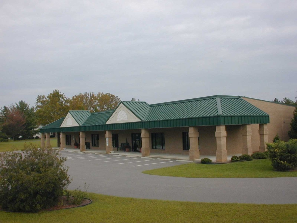
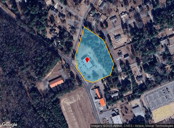
Property Record
7305 Nc 22 Hwy, Carthage, NC 28327
NEARBY LISTINGS FOR SALE OR LEASE
Property Detail
7305 Nc 22 Hwy
8574-02-86-3232
Wedgewood
Storebuilding
WEDGEWOOD LAND
X
Moore
3710857400J
North Carolina
2024
4.01 AC
2024
Other Market Areas
950506
Pinehurst-Southern Pines, NC
7,500 SF
DEMOGRAPHICS near 7305 Nc 22 Hwy
1 Mile
3 Mile
5 Mile
2024 Total Population
1,807
12,714
32,850
2029 Population
2,082
14,654
37,935
Pop Growth 2024-2029
+ 15.22%
+ 15.26%
+ 15.48%
Average Age
38
43
43
2024 Total Households
632
5,115
13,977
HH Growth 2024-2029
+ 15.51%
+ 15.62%
+ 15.83%
Median Household Inc
$104,657
$87,730
$78,441
Avg Household Size
2.80
2.50
2.30
2024 Avg HH Vehicles
2.00
2.00
2.00
Median Home Value
$402,235
$363,877
$348,432
Median Year Built
2003
1998
1997
Nearby Places
- Restaurants
- Banks
- Shops
- Fitness
- Groceries
PUBLIC TRANSPORTATION
COMMUTER RAIL
Southern Pines Amtrak Station (Silver Star - Amtrak)
DRIVE
WALK
Distance
Southern Pines Amtrak Station (Silver Star - Amtrak)
10 min
6.0 mi
Freight Ports
Port of Wilmington
DRIVE
WALK
Distance
Port of Wilmington
178 min
140.3 mi
SALE & LEASE HISTORY
LISTING DATE
SALE/LEASE

Mar 12, 2018
For Lease
Nearby Properties
Address
Land Use
TOTAL SIZE
Lot Size
Zoning
Address
Land Use
TOTAL SIZE
Lot Size
Zoning
24,520 SF
94.90 AC
PPCC
Address
Land Use
TOTAL SIZE
Lot Size
Zoning
30,190 SF
181.04 AC
PPC
Address
Land Use
TOTAL SIZE
Lot Size
Zoning
39.86 AC
Address
Land Use
TOTAL SIZE
Lot Size
Zoning
24,942 SF
39.99 AC
MULTI
Address
Land Use
TOTAL SIZE
Lot Size
Zoning
15,900 SF
179.30 AC
MULTI
Address
Land Use
TOTAL SIZE
Lot Size
Zoning
15,422 SF
35.21 AC
R20
Address
Land Use
TOTAL SIZE
Lot Size
Zoning
53,926 SF
21.69 AC
GB
Address
Land Use
TOTAL SIZE
Lot Size
Zoning
10,435 SF
11.26 AC
R20
Address
Land Use
TOTAL SIZE
Lot Size
Zoning
36 SF
181.27 AC
RD
Address
Land Use
TOTAL SIZE
Lot Size
Zoning
15,220 SF
11.76 AC
RA
Address
Land Use
TOTAL SIZE
Lot Size
Zoning
840 SF
63 AC
RA
Address
Land Use
TOTAL SIZE
Lot Size
Zoning
12,045 SF
2 AC
RE
Address
Land Use
TOTAL SIZE
Lot Size
Zoning
10,204 SF
11.14 AC
R20
Address
Land Use
TOTAL SIZE
Lot Size
Zoning
35,262 SF
11.38 AC
NSCD
Address
Land Use
TOTAL SIZE
Lot Size
Zoning
Address
Land Use
TOTAL SIZE
Lot Size
Zoning
183.03 AC
RA40
Address
Land Use
TOTAL SIZE
Lot Size
Zoning
13,628 SF
4.15 AC
B2
Address
Land Use
TOTAL SIZE
Lot Size
Zoning
2,540 SF
22.51 AC
PPC
Address
Land Use
TOTAL SIZE
Lot Size
Zoning
Address
Land Use
TOTAL SIZE
Lot Size
Zoning
3.75 AC
Address
Land Use
TOTAL SIZE
Lot Size
Zoning
6,810 SF
300.85 AC
R
Address
Land Use
TOTAL SIZE
Lot Size
Zoning
3.80 AC
PD
Address
Land Use
TOTAL SIZE
Lot Size
Zoning
8,412 SF
12.56 AC
RS3
Address
Land Use
TOTAL SIZE
Lot Size
Zoning
125.53 AC
Address
Land Use
TOTAL SIZE
Lot Size
Zoning
4,120 SF
3.79 AC
PD
Address
Land Use
TOTAL SIZE
Lot Size
Zoning
3,900 SF
6.02 AC
PPC
Address
Land Use
TOTAL SIZE
Lot Size
Zoning
4,872 SF
14.73 AC
RS3
Address
Land Use
TOTAL SIZE
Lot Size
Zoning
Address
Land Use
TOTAL SIZE
Lot Size
Zoning
1,683 SF
1 AC
RM1
Address
Land Use
TOTAL SIZE
Lot Size
Zoning
5,461 SF
10.33 AC
The World's #1 Commercial Real Estate Marketplace
Connect with us
© 2025 CoStar Group
The information above has been obtained from sources believed reliable. While we do not doubt its accuracy we have not verified it and make no guarantee, warranty or representation about it. It is your responsibility to independently confirm its accuracy and completeness. Any projections, opinions, assumptions, or estimates used are for example only and do not represent the current or future performance of the property. The value of this transaction to you depends on tax and other factors which should be evaluated by your tax, financial, and legal advisors. You and your advisors should conduct a careful, independent investigation of the property to determine to your satisfaction the suitability of the property for your needs.