Property Record
7306 White House Dr, Anderson, CA 96007
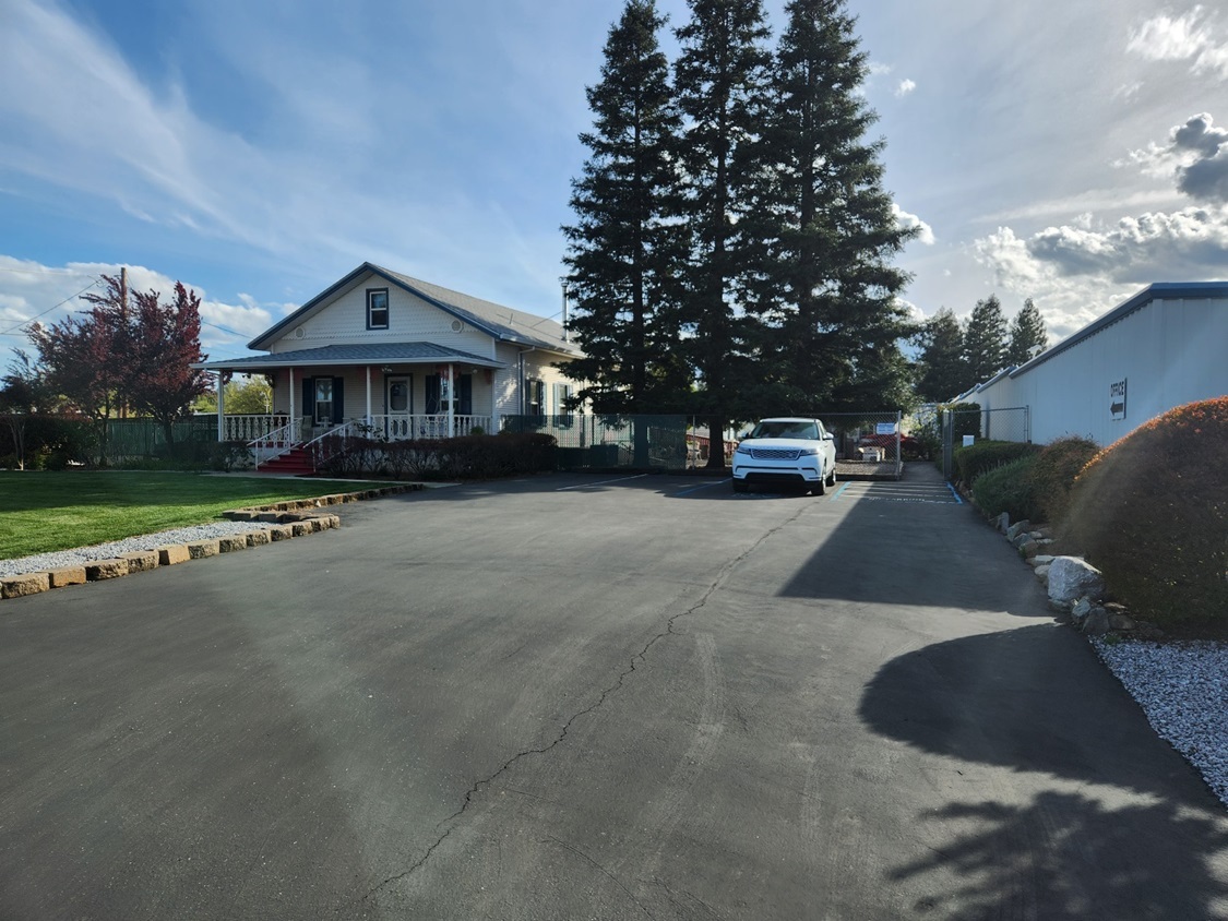
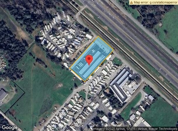

This Property Is For Sale
NEARBY LISTINGS FOR SALE OR LEASE
-
-
View all Anderson listings for sale on LoopNet.com
Property Detail
7306 White House Dr
051-060-005-000
P B Reading Grant
Publicstorage
Shasta
X
California
06089C1930G
1.80 AC
2023
Redding/Chico
2024
Other Market Areas
012301
Redding, CA
9,000 SF
DEMOGRAPHICS near 7306 White House Dr
1 Mile
3 Mile
5 Mile
2024 Total Population
1,992
12,902
55,010
2029 Population
1,998
12,934
55,084
Pop Growth 2024-2029
+ 0.30%
+ 0.25%
+ 0.13%
Average Age
41
42
41
2024 Total Households
810
4,975
20,990
HH Growth 2024-2029
+ 0.25%
+ 0.22%
+ 0.14%
Median Household Inc
$37,592
$58,567
$64,823
Avg Household Size
2.40
2.50
2.50
2024 Avg HH Vehicles
2.00
2.00
2.00
Median Home Value
$215,407
$314,204
$334,140
Median Year Built
1975
1977
1979
Nearby Places
- Restaurants
- Banks
- Shops
- Fitness
- Groceries
PUBLIC TRANSPORTATION
COMMUTER RAIL
Redding Amtrak (Coast Starlight - Amtrak)
DRIVE
WALK
Distance
Redding Amtrak (Coast Starlight - Amtrak)
11 min
6.7 mi
AIRPORT
Redding Regional
DRIVE
WALK
Distance
Redding Regional
13 min
8.4 mi
Freight Ports
Port of Richmond
DRIVE
WALK
Distance
Port of Richmond
225 min
199.2 mi
Nearby Properties
Address
Land Use
TOTAL SIZE
Lot Size
Zoning
Address
Land Use
TOTAL SIZE
Lot Size
Zoning
Address
Land Use
TOTAL SIZE
Lot Size
Zoning
344.24 AC
U
Address
Land Use
TOTAL SIZE
Lot Size
Zoning
20.19 AC
C-M
Address
Land Use
TOTAL SIZE
Lot Size
Zoning
3.50 AC
M-L
Address
Land Use
TOTAL SIZE
Lot Size
Zoning
8.31 AC
Address
Land Use
TOTAL SIZE
Lot Size
Zoning
1,175 SF
3.91 AC
Address
Land Use
TOTAL SIZE
Lot Size
Zoning
56,474 SF
19.20 AC
Address
Land Use
TOTAL SIZE
Lot Size
Zoning
7.56 AC
Address
Land Use
TOTAL SIZE
Lot Size
Zoning
2.58 AC
Address
Land Use
TOTAL SIZE
Lot Size
Zoning
1,820 SF
16.80 AC
Address
Land Use
TOTAL SIZE
Lot Size
Zoning
1,440 SF
17.13 AC
R-R-T-BA-9
Address
Land Use
TOTAL SIZE
Lot Size
Zoning
18,648 SF
2.61 AC
Address
Land Use
TOTAL SIZE
Lot Size
Zoning
13.10 AC
C-M-DR
Address
Land Use
TOTAL SIZE
Lot Size
Zoning
6.23 AC
Address
Land Use
TOTAL SIZE
Lot Size
Zoning
20.39 AC
C-R
Address
Land Use
TOTAL SIZE
Lot Size
Zoning
17.22 AC
M
Address
Land Use
TOTAL SIZE
Lot Size
Zoning
1.30 AC
Address
Land Use
TOTAL SIZE
Lot Size
Zoning
4,410 SF
5.67 AC
PD-MRB
Address
Land Use
TOTAL SIZE
Lot Size
Zoning
20,000 SF
10.12 AC
Address
Land Use
TOTAL SIZE
Lot Size
Zoning
1.11 AC
Address
Land Use
TOTAL SIZE
Lot Size
Zoning
Address
Land Use
TOTAL SIZE
Lot Size
Zoning
2,764 SF
29.42 AC
A-1
Address
Land Use
TOTAL SIZE
Lot Size
Zoning
2,680 SF
0.72 AC
Address
Land Use
TOTAL SIZE
Lot Size
Zoning
5,000 SF
5 AC
M
Address
Land Use
TOTAL SIZE
Lot Size
Zoning
1,440 SF
6.68 AC
C-M
Address
Land Use
TOTAL SIZE
Lot Size
Zoning
2,632 SF
40 AC
M
Address
Land Use
TOTAL SIZE
Lot Size
Zoning
3.04 AC
Address
Land Use
TOTAL SIZE
Lot Size
Zoning
300 SF
3.61 AC
C-M
Address
Land Use
TOTAL SIZE
Lot Size
Zoning
2.74 AC
Address
Land Use
TOTAL SIZE
Lot Size
Zoning
19,500 SF
1.66 AC
The World's #1 Commercial Real Estate Marketplace
Connect with us
© 2025 CoStar Group
The information above has been obtained from sources believed reliable. While we do not doubt its accuracy we have not verified it and make no guarantee, warranty or representation about it. It is your responsibility to independently confirm its accuracy and completeness. Any projections, opinions, assumptions, or estimates used are for example only and do not represent the current or future performance of the property. The value of this transaction to you depends on tax and other factors which should be evaluated by your tax, financial, and legal advisors. You and your advisors should conduct a careful, independent investigation of the property to determine to your satisfaction the suitability of the property for your needs.