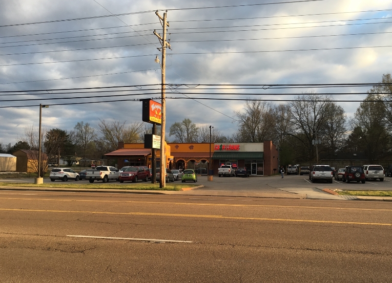
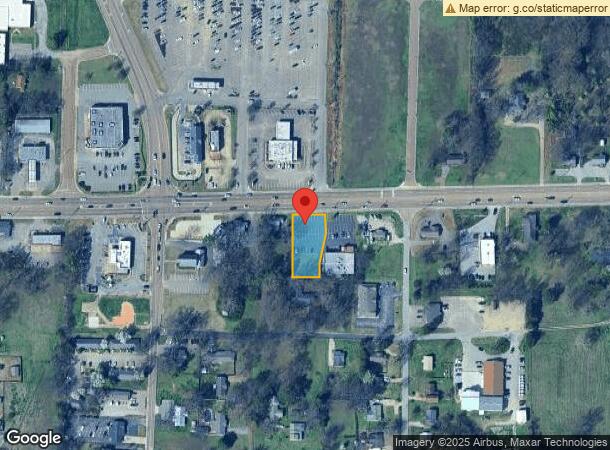
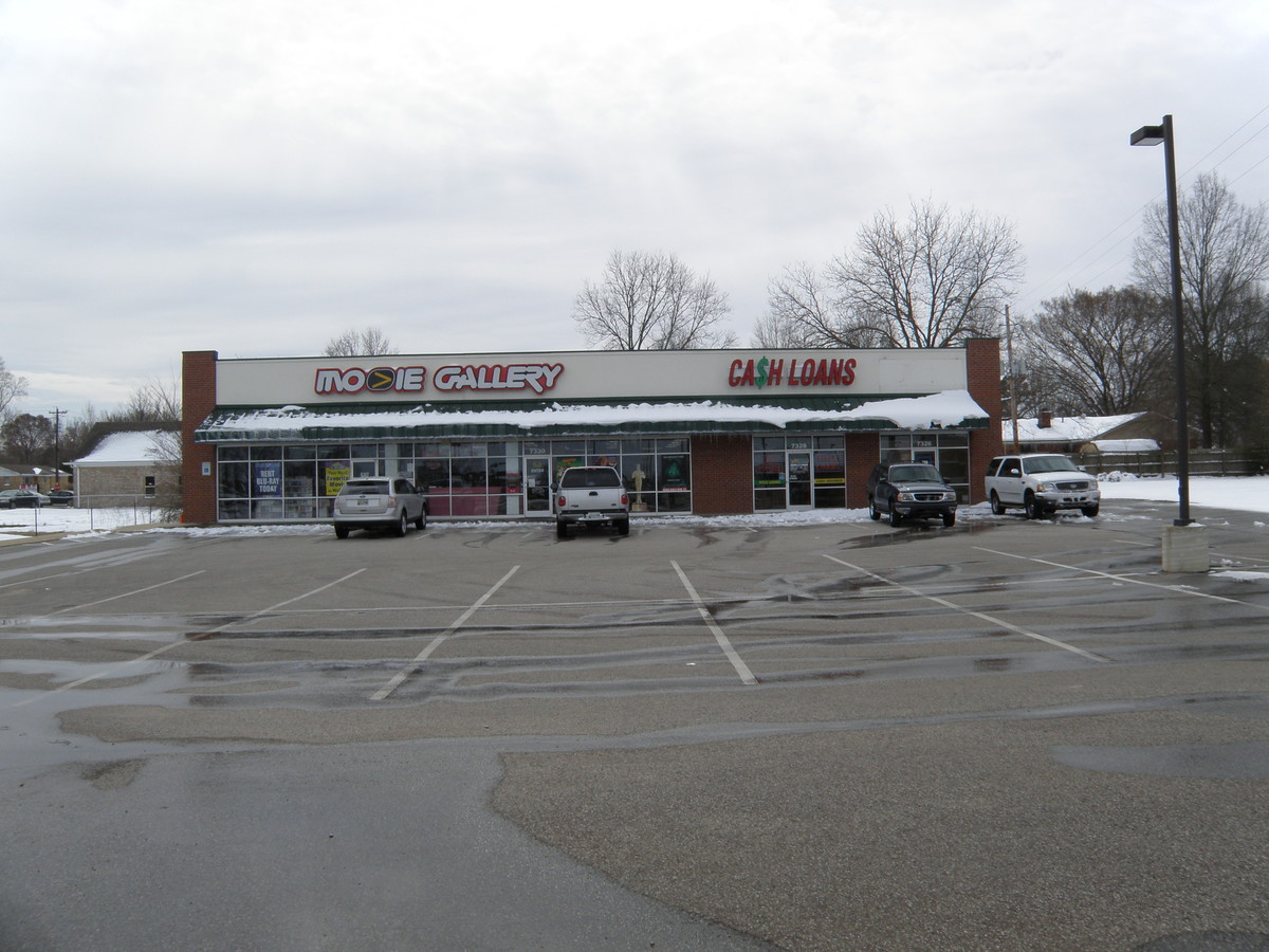
Property Record
7310 Highway 64, Oakland, TN 38060
NEARBY LISTINGS FOR SALE OR LEASE
Property Detail
7310 Highway 64
Memphis, TN-MS-AR
Bertram Subd
087I-B-005.00
BERTRAM SUBD PB: 8 PG: 47 LOT: 1 GIS 2000 87I B 4.00 100 X 195 IRR
Commercialnec
Fayette
X
Tennessee
47047C0285C
1
2024
1 AC
2024
Fayette County
060404
Memphis
2,314 SF
DEMOGRAPHICS near 7310 Highway 64
1 Mile
3 Mile
5 Mile
2024 Total Population
4,160
11,884
16,581
2029 Population
4,657
13,230
18,375
Pop Growth 2024-2029
+ 11.95%
+ 11.33%
+ 10.82%
Average Age
43
42
43
2024 Total Households
1,678
4,708
6,518
HH Growth 2024-2029
+ 11.68%
+ 11.09%
+ 10.59%
Median Household Inc
$78,765
$80,427
$80,866
Avg Household Size
2.50
2.50
2.50
2024 Avg HH Vehicles
2.00
2.00
2.00
Median Home Value
$207,597
$216,570
$239,879
Median Year Built
2006
2004
2003
Nearby Places
- Restaurants
- Banks
- Shops
- Fitness
- Groceries
PUBLIC TRANSPORTATION
AIRPORT
Memphis International
DRIVE
WALK
Distance
Memphis International
50 min
36.3 mi
Freight Ports
Port of Shreveport
DRIVE
WALK
Distance
Port of Shreveport
442 min
403.6 mi
SALE & LEASE HISTORY
LISTING DATE
SALE/LEASE

Oct 19, 2016
For Lease
Nearby Properties
Address
Land Use
TOTAL SIZE
Lot Size
Zoning
Address
Land Use
TOTAL SIZE
Lot Size
Zoning
68,475 SF
25.06 AC
Address
Land Use
TOTAL SIZE
Lot Size
Zoning
85,388 SF
11.24 AC
Address
Land Use
TOTAL SIZE
Lot Size
Zoning
152,083 SF
18.36 AC
B2PDM
Address
Land Use
TOTAL SIZE
Lot Size
Zoning
251,653 SF
35.94 AC
M1
Address
Land Use
TOTAL SIZE
Lot Size
Zoning
19,500 SF
18.94 AC
Address
Land Use
TOTAL SIZE
Lot Size
Zoning
37,500 SF
3.25 AC
B1PDM
Address
Land Use
TOTAL SIZE
Lot Size
Zoning
48,398 SF
7.44 AC
B2
Address
Land Use
TOTAL SIZE
Lot Size
Zoning
35,825 SF
4.86 AC
B2
Address
Land Use
TOTAL SIZE
Lot Size
Zoning
36,630 SF
5.59 AC
B2
Address
Land Use
TOTAL SIZE
Lot Size
Zoning
3,982 SF
4.85 AC
B2
Address
Land Use
TOTAL SIZE
Lot Size
Zoning
13,650 SF
1.78 AC
B2
Address
Land Use
TOTAL SIZE
Lot Size
Zoning
7,104 SF
2.87 AC
B2
Address
Land Use
TOTAL SIZE
Lot Size
Zoning
3,554 SF
1.08 AC
B1PDM
Address
Land Use
TOTAL SIZE
Lot Size
Zoning
3,250 SF
1.11 AC
B2PDM
Address
Land Use
TOTAL SIZE
Lot Size
Zoning
43,500 SF
15.06 AC
M2
Address
Land Use
TOTAL SIZE
Lot Size
Zoning
6,750 SF
1.07 AC
B2
Address
Land Use
TOTAL SIZE
Lot Size
Zoning
19,600 SF
3.63 AC
B2
Address
Land Use
TOTAL SIZE
Lot Size
Zoning
138.42 AC
Address
Land Use
TOTAL SIZE
Lot Size
Zoning
2,000 SF
22.69 AC
M2
Address
Land Use
TOTAL SIZE
Lot Size
Zoning
5,168 SF
1.11 AC
B2
Address
Land Use
TOTAL SIZE
Lot Size
Zoning
17,220 SF
1.46 AC
B2
Address
Land Use
TOTAL SIZE
Lot Size
Zoning
15,501 SF
2.06 AC
B2
Address
Land Use
TOTAL SIZE
Lot Size
Zoning
6,661 SF
2.93 AC
B2
Address
Land Use
TOTAL SIZE
Lot Size
Zoning
11,190 SF
1.06 AC
Address
Land Use
TOTAL SIZE
Lot Size
Zoning
39,600 SF
2.03 AC
B2
Address
Land Use
TOTAL SIZE
Lot Size
Zoning
18,454 SF
1.10 AC
B2
Address
Land Use
TOTAL SIZE
Lot Size
Zoning
11,420 SF
3.09 AC
M2
Address
Land Use
TOTAL SIZE
Lot Size
Zoning
9,000 SF
1.28 AC
B2PDM
Address
Land Use
TOTAL SIZE
Lot Size
Zoning
4,672 SF
1.92 AC
B2
Address
Land Use
TOTAL SIZE
Lot Size
Zoning
11,040 SF
0.94 AC
B2
The World's #1 Commercial Real Estate Marketplace
Connect with us
© 2025 CoStar Group
The information above has been obtained from sources believed reliable. While we do not doubt its accuracy we have not verified it and make no guarantee, warranty or representation about it. It is your responsibility to independently confirm its accuracy and completeness. Any projections, opinions, assumptions, or estimates used are for example only and do not represent the current or future performance of the property. The value of this transaction to you depends on tax and other factors which should be evaluated by your tax, financial, and legal advisors. You and your advisors should conduct a careful, independent investigation of the property to determine to your satisfaction the suitability of the property for your needs.