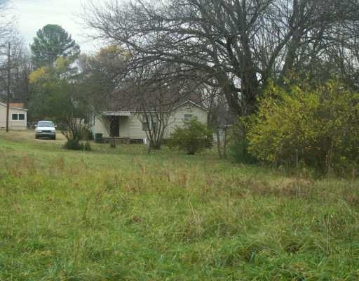
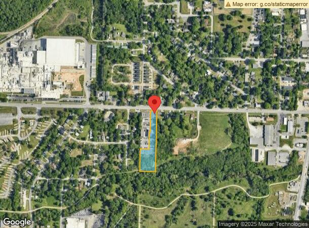
Property Record
735 W 15Th St, Fayetteville, AR 72701
NEARBY LISTINGS FOR SALE OR LEASE
Property Detail
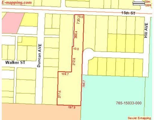
735 W 15Th St
765-15036-000
Fayetteville Outlots
Apartment
PT NE SW 2.28A FURTHER DESCRIBED FROM 2018-7943 AS: PART OF THE NE/4 OF THE SW/4 OF SECTION 21 , T16N, R30W IN WASHINGTON COU
AE
Washington
05143C0216G
Arkansas
2024
2.28 AC
2024
Greater Fayetteville
011105
Fayetteville/Springdale/Rogers
45,204 SF
Fayetteville-Springdale-Rogers, AR-MO
DEMOGRAPHICS near 735 W 15Th St
1 Mile
3 Mile
5 Mile
2024 Total Population
8,390
51,591
101,412
2029 Population
9,265
56,444
110,970
Pop Growth 2024-2029
+ 10.43%
+ 9.41%
+ 9.42%
Average Age
31
31
34
2024 Total Households
3,491
20,974
41,444
HH Growth 2024-2029
+ 10.68%
+ 10.57%
+ 10.12%
Median Household Inc
$34,947
$40,771
$61,166
Avg Household Size
2.10
2.00
2.20
2024 Avg HH Vehicles
2.00
2.00
2.00
Median Home Value
$180,420
$281,015
$270,962
Median Year Built
2002
1991
1995
Nearby Places
- Restaurants
- Banks
- Shops
- Fitness
- Groceries
PUBLIC TRANSPORTATION
AIRPORT
Northwest Arkansas Ntl
DRIVE
WALK
Distance
Northwest Arkansas Ntl
43 min
23.8 mi
Freight Ports
Tulsa Port of Inola
DRIVE
WALK
Distance
Tulsa Port of Inola
112 min
91.9 mi
SALE & LEASE HISTORY
LISTING DATE
SALE/LEASE

Nov 15, 2017
For Sale
Nearby Properties
Address
Land Use
TOTAL SIZE
Lot Size
Zoning
Address
Land Use
TOTAL SIZE
Lot Size
Zoning
92,872 SF
15.37 AC
Address
Land Use
TOTAL SIZE
Lot Size
Zoning
27,060 SF
26.31 AC
Address
Land Use
TOTAL SIZE
Lot Size
Zoning
316,846 SF
2.31 AC
I1
Address
Land Use
TOTAL SIZE
Lot Size
Zoning
63,080 SF
3.42 AC
Address
Land Use
TOTAL SIZE
Lot Size
Zoning
42,327 SF
13.28 AC
I1
Address
Land Use
TOTAL SIZE
Lot Size
Zoning
45,300 SF
16.38 AC
Address
Land Use
TOTAL SIZE
Lot Size
Zoning
19,544 SF
18.79 AC
Address
Land Use
TOTAL SIZE
Lot Size
Zoning
193,590 SF
8.67 AC
I1
Address
Land Use
TOTAL SIZE
Lot Size
Zoning
371,436 SF
29.18 AC
I2
Address
Land Use
TOTAL SIZE
Lot Size
Zoning
16,409 SF
17.40 AC
C1
Address
Land Use
TOTAL SIZE
Lot Size
Zoning
176,747 SF
4.98 AC
Address
Land Use
TOTAL SIZE
Lot Size
Zoning
191,928 SF
0.81 AC
C4
Address
Land Use
TOTAL SIZE
Lot Size
Zoning
62,644 SF
0.49 AC
R3
Address
Land Use
TOTAL SIZE
Lot Size
Zoning
40,964 SF
10.59 AC
F
Address
Land Use
TOTAL SIZE
Lot Size
Zoning
48,120 SF
0.53 AC
R3
Address
Land Use
TOTAL SIZE
Lot Size
Zoning
13,012 SF
10.36 AC
I2
Address
Land Use
TOTAL SIZE
Lot Size
Zoning
73,886 SF
6.59 AC
C2
Address
Land Use
TOTAL SIZE
Lot Size
Zoning
145,586 SF
2.18 AC
R3
Address
Land Use
TOTAL SIZE
Lot Size
Zoning
36,104 SF
8.36 AC
I1
Address
Land Use
TOTAL SIZE
Lot Size
Zoning
86,794 SF
0.33 AC
Address
Land Use
TOTAL SIZE
Lot Size
Zoning
78,284 SF
0.43 AC
Address
Land Use
TOTAL SIZE
Lot Size
Zoning
171,828 SF
9.95 AC
R2
Address
Land Use
TOTAL SIZE
Lot Size
Zoning
254,783 SF
28.46 AC
C2
Address
Land Use
TOTAL SIZE
Lot Size
Zoning
325,150 SF
23.71 AC
I2
Address
Land Use
TOTAL SIZE
Lot Size
Zoning
22,208 SF
5.22 AC
Address
Land Use
TOTAL SIZE
Lot Size
Zoning
302,144 SF
30.99 AC
AA1
Address
Land Use
TOTAL SIZE
Lot Size
Zoning
663,900 SF
46.74 AC
I2
Address
Land Use
TOTAL SIZE
Lot Size
Zoning
259,706 SF
5.31 AC
C2
Address
Land Use
TOTAL SIZE
Lot Size
Zoning
86,260 SF
4.15 AC
Address
Land Use
TOTAL SIZE
Lot Size
Zoning
39,936 SF
1.68 AC
The World's #1 Commercial Real Estate Marketplace
Connect with us
© 2025 CoStar Group
The information above has been obtained from sources believed reliable. While we do not doubt its accuracy we have not verified it and make no guarantee, warranty or representation about it. It is your responsibility to independently confirm its accuracy and completeness. Any projections, opinions, assumptions, or estimates used are for example only and do not represent the current or future performance of the property. The value of this transaction to you depends on tax and other factors which should be evaluated by your tax, financial, and legal advisors. You and your advisors should conduct a careful, independent investigation of the property to determine to your satisfaction the suitability of the property for your needs.