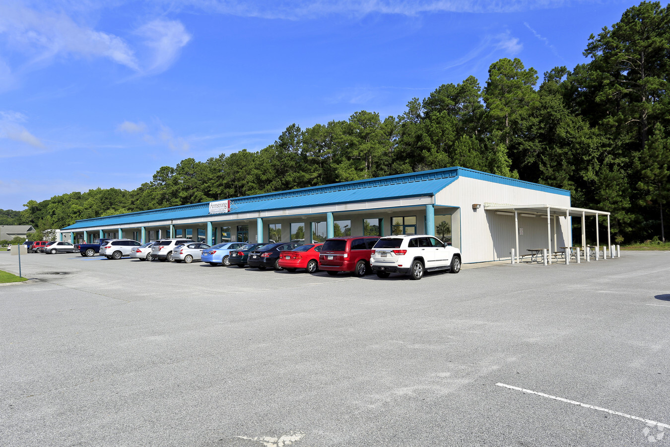
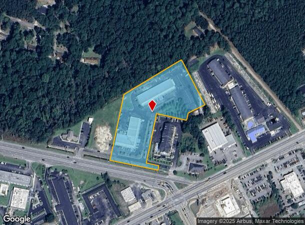
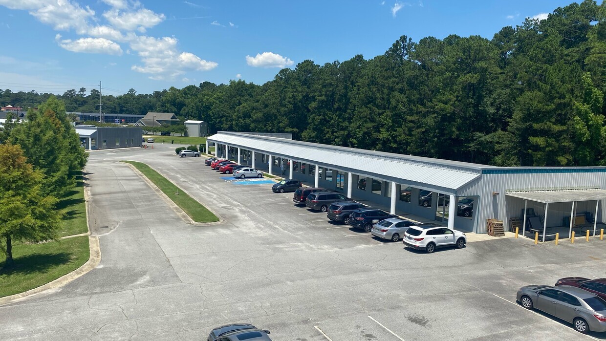
Property Record
740 E General Stewart Way, Hinesville, GA 31313
Current Lease Availabilities
NEARBY LISTINGS FOR SALE OR LEASE
Property Detail
740 E General Stewart Way
069C-025
Gmass Commercial
Stripcommercialcenter
4.88 AC N/S E GEN STEWART WAY(PATRIOT PLAZA)
X
Liberty
13179C0227F
Georgia
2024
4.88 AC
2023
Liberty County
010302
Savannah
15,000 SF
Hinesville, GA
DEMOGRAPHICS near 740 E General Stewart Way
1 Mile
3 Mile
5 Mile
2024 Total Population
3,731
27,350
46,485
2029 Population
3,880
28,735
48,768
Pop Growth 2024-2029
+ 3.99%
+ 5.06%
+ 4.91%
Average Age
33
31
31
2024 Total Households
1,524
9,233
15,964
HH Growth 2024-2029
+ 4.33%
+ 5.58%
+ 5.29%
Median Household Inc
$39,697
$45,243
$46,780
Avg Household Size
2.40
2.60
2.70
2024 Avg HH Vehicles
1.00
2.00
2.00
Median Home Value
$165,822
$153,986
$150,390
Median Year Built
1985
1990
1991
Nearby Places
- Restaurants
- Banks
- Shops
- Fitness
- Groceries
PUBLIC TRANSPORTATION
AIRPORT
Savannah/Hilton Head International
DRIVE
WALK
Distance
Savannah/Hilton Head International
54 min
37.8 mi
Freight Ports
Georgia Ports - Savannah
DRIVE
WALK
Distance
Georgia Ports - Savannah
56 min
40.5 mi
Nearby Properties
Address
Land Use
TOTAL SIZE
Lot Size
Zoning
Address
Land Use
TOTAL SIZE
Lot Size
Zoning
315,645 SF
57.37 AC
A1/R8
Address
Land Use
TOTAL SIZE
Lot Size
Zoning
2,352 SF
22.31 AC
ATR/MFR
Address
Land Use
TOTAL SIZE
Lot Size
Zoning
144,251 SF
51.30 AC
R20
Address
Land Use
TOTAL SIZE
Lot Size
Zoning
102,939 SF
2.53 AC
C1
Address
Land Use
TOTAL SIZE
Lot Size
Zoning
41,670 SF
1.89 AC
C1
Address
Land Use
TOTAL SIZE
Lot Size
Zoning
148,364 SF
18.53 AC
PUD
Address
Land Use
TOTAL SIZE
Lot Size
Zoning
100,765 SF
33.20 AC
C2
Address
Land Use
TOTAL SIZE
Lot Size
Zoning
60,432 SF
23.64 AC
R20
Address
Land Use
TOTAL SIZE
Lot Size
Zoning
90,886 SF
10.78 AC
C2
Address
Land Use
TOTAL SIZE
Lot Size
Zoning
1,884 SF
9.25 AC
C2
Address
Land Use
TOTAL SIZE
Lot Size
Zoning
205,730 SF
21.03 AC
C3
Address
Land Use
TOTAL SIZE
Lot Size
Zoning
57,980 SF
10.72 AC
C2
Address
Land Use
TOTAL SIZE
Lot Size
Zoning
155,001 SF
10.56 AC
MFR
Address
Land Use
TOTAL SIZE
Lot Size
Zoning
17,376 SF
29.45 AC
OI
Address
Land Use
TOTAL SIZE
Lot Size
Zoning
110,150 SF
14.83 AC
C3
Address
Land Use
TOTAL SIZE
Lot Size
Zoning
42,572 SF
5.87 AC
C2
Address
Land Use
TOTAL SIZE
Lot Size
Zoning
133,379 SF
15.59 AC
C2
Address
Land Use
TOTAL SIZE
Lot Size
Zoning
27,627 SF
4.97 AC
C2
Address
Land Use
TOTAL SIZE
Lot Size
Zoning
34,334 SF
7.10 AC
C2
Address
Land Use
TOTAL SIZE
Lot Size
Zoning
105,967 SF
11.18 AC
C2
Address
Land Use
TOTAL SIZE
Lot Size
Zoning
7,874 SF
2.34 AC
DD
Address
Land Use
TOTAL SIZE
Lot Size
Zoning
24,144 SF
9.24 AC
C3
Address
Land Use
TOTAL SIZE
Lot Size
Zoning
35,588 SF
8.88 AC
FTSTEWART
Address
Land Use
TOTAL SIZE
Lot Size
Zoning
51,168 SF
12 AC
MFR
Address
Land Use
TOTAL SIZE
Lot Size
Zoning
34,484 SF
1.92 AC
C2
Address
Land Use
TOTAL SIZE
Lot Size
Zoning
36,289 SF
2.57 AC
C2
Address
Land Use
TOTAL SIZE
Lot Size
Zoning
52,137 SF
6.12 AC
C2
Address
Land Use
TOTAL SIZE
Lot Size
Zoning
21,685 SF
1.15 AC
C2
Address
Land Use
TOTAL SIZE
Lot Size
Zoning
42,110 SF
5.86 AC
C3
The World's #1 Commercial Real Estate Marketplace
Connect with us
© 2025 CoStar Group
The information above has been obtained from sources believed reliable. While we do not doubt its accuracy we have not verified it and make no guarantee, warranty or representation about it. It is your responsibility to independently confirm its accuracy and completeness. Any projections, opinions, assumptions, or estimates used are for example only and do not represent the current or future performance of the property. The value of this transaction to you depends on tax and other factors which should be evaluated by your tax, financial, and legal advisors. You and your advisors should conduct a careful, independent investigation of the property to determine to your satisfaction the suitability of the property for your needs.