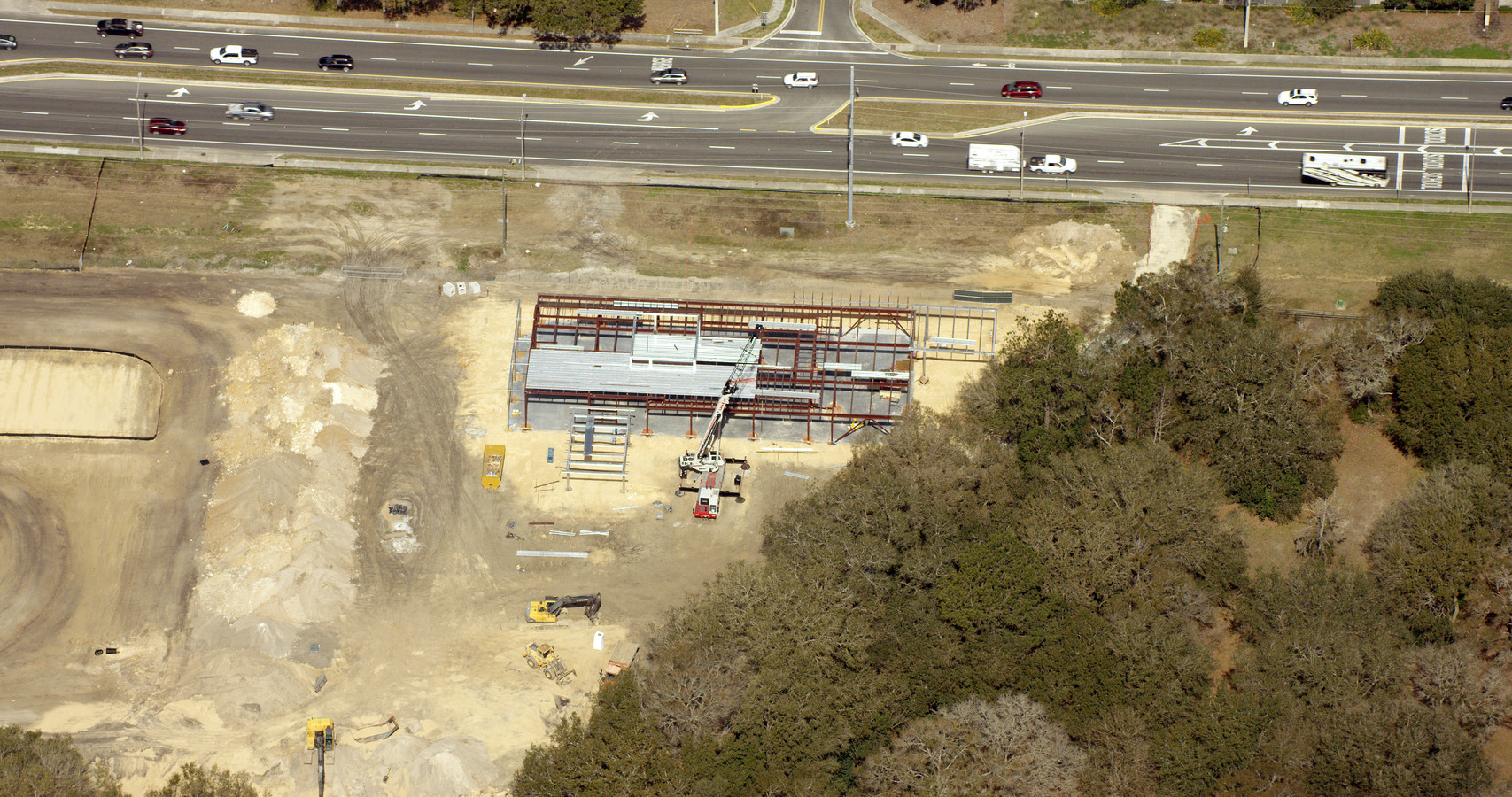
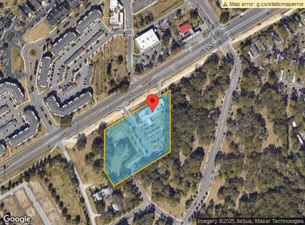
Property Record
7405 Sw Archer Rd, Gainesville, FL 32608
NEARBY LISTINGS FOR SALE OR LEASE
Property Detail
7405 Sw Archer Rd
Gainesville, FL
Smithers Survey
07048-000-000
SMITHERS SURVEY PB A-113 COM INTERSECTION S RR/W & W LINE SEC S 420 FT NELY PAR WITH RR/W 525 FT N 420 FT M/L TO RR/W SWLY ALONG R/W TO POB LESS 75 FT ON S TRIANGLE IN SW COR PER OR 1551/254) VACATED PER RES 15-87 OR 4373/1497 OR 4320/2066
Hospitalpublic
Alachua
X
Florida
12001C0435E
7
2023
4.91 AC
2024
South Gainesville
002220
Other Market Areas
10,828 SF
DEMOGRAPHICS near 7405 Sw Archer Rd
1 Mile
3 Mile
5 Mile
2024 Total Population
7,007
31,828
98,063
2029 Population
7,406
34,118
103,492
Pop Growth 2024-2029
+ 5.69%
+ 7.19%
+ 5.54%
Average Age
38
39
35
2024 Total Households
2,854
12,882
39,860
HH Growth 2024-2029
+ 5.78%
+ 7.41%
+ 5.57%
Median Household Inc
$87,340
$92,126
$54,036
Avg Household Size
2.40
2.40
2.30
2024 Avg HH Vehicles
2.00
2.00
2.00
Median Home Value
$310,911
$338,641
$316,577
Median Year Built
1996
1997
1991
Nearby Places
- Restaurants
- Banks
- Shops
- Fitness
- Groceries
PUBLIC TRANSPORTATION
AIRPORT
Gainesville Regional
DRIVE
WALK
Distance
Gainesville Regional
28 min
12.7 mi
Freight Ports
Jacksonville Port
DRIVE
WALK
Distance
Jacksonville Port
113 min
82.5 mi
Nearby Properties
Address
Land Use
TOTAL SIZE
Lot Size
Zoning
Address
Land Use
TOTAL SIZE
Lot Size
Zoning
318,578 SF
21.24 AC
RMF7
Address
Land Use
TOTAL SIZE
Lot Size
Zoning
332,878 SF
34.15 AC
PD
Address
Land Use
TOTAL SIZE
Lot Size
Zoning
134,068 SF
3.47 AC
R-2
Address
Land Use
TOTAL SIZE
Lot Size
Zoning
354,707 SF
25.98 AC
RMF8
Address
Land Use
TOTAL SIZE
Lot Size
Zoning
371,933 SF
15 AC
PD
Address
Land Use
TOTAL SIZE
Lot Size
Zoning
309,967 SF
12.58 AC
PD
Address
Land Use
TOTAL SIZE
Lot Size
Zoning
205,412 SF
23.80 AC
R-1A
Address
Land Use
TOTAL SIZE
Lot Size
Zoning
311,673 SF
34.15 AC
R-2
Address
Land Use
TOTAL SIZE
Lot Size
Zoning
307,316 SF
25.99 AC
R-2
Address
Land Use
TOTAL SIZE
Lot Size
Zoning
29,190 SF
4.21 AC
BI
Address
Land Use
TOTAL SIZE
Lot Size
Zoning
112,213 SF
18.62 AC
R-1AA
Address
Land Use
TOTAL SIZE
Lot Size
Zoning
102,304 SF
2.79 AC
BUS
Address
Land Use
TOTAL SIZE
Lot Size
Zoning
311,290 SF
25.20 AC
R-1A
Address
Land Use
TOTAL SIZE
Lot Size
Zoning
97,648 SF
44.62 AC
A
Address
Land Use
TOTAL SIZE
Lot Size
Zoning
87,104 SF
14.59 AC
PD
Address
Land Use
TOTAL SIZE
Lot Size
Zoning
168,512 SF
15.22 AC
R-2
Address
Land Use
TOTAL SIZE
Lot Size
Zoning
111,638 SF
10.49 AC
PD
Address
Land Use
TOTAL SIZE
Lot Size
Zoning
86,343 SF
4.03 AC
BI
Address
Land Use
TOTAL SIZE
Lot Size
Zoning
140,592 SF
66.88 AC
RM
Address
Land Use
TOTAL SIZE
Lot Size
Zoning
64,710 SF
8.30 AC
PD
Address
Land Use
TOTAL SIZE
Lot Size
Zoning
407,034 SF
2.35 AC
R-1AA
Address
Land Use
TOTAL SIZE
Lot Size
Zoning
150,324 SF
3.22 AC
R-1AA
Address
Land Use
TOTAL SIZE
Lot Size
Zoning
92,735 SF
1.07 AC
R-1A
Address
Land Use
TOTAL SIZE
Lot Size
Zoning
184,578 SF
17.72 AC
PD
Address
Land Use
TOTAL SIZE
Lot Size
Zoning
106,659 SF
10.21 AC
R-2A
Address
Land Use
TOTAL SIZE
Lot Size
Zoning
66,497 SF
3.15 AC
RMF8
Address
Land Use
TOTAL SIZE
Lot Size
Zoning
59,960 SF
1.91 AC
BI
Address
Land Use
TOTAL SIZE
Lot Size
Zoning
50,240 SF
41.99 AC
RM
Address
Land Use
TOTAL SIZE
Lot Size
Zoning
73,224 SF
2.56 AC
BI
Address
Land Use
TOTAL SIZE
Lot Size
Zoning
97,174 SF
11.94 AC
PD
The World's #1 Commercial Real Estate Marketplace
Connect with us
© 2025 CoStar Group
The information above has been obtained from sources believed reliable. While we do not doubt its accuracy we have not verified it and make no guarantee, warranty or representation about it. It is your responsibility to independently confirm its accuracy and completeness. Any projections, opinions, assumptions, or estimates used are for example only and do not represent the current or future performance of the property. The value of this transaction to you depends on tax and other factors which should be evaluated by your tax, financial, and legal advisors. You and your advisors should conduct a careful, independent investigation of the property to determine to your satisfaction the suitability of the property for your needs.