Property Record
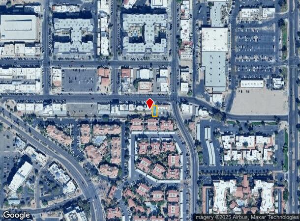
7431 E 6Th Ave, Scottsdale, AZ 85251

NEARBY LISTINGS FOR SALE OR LEASE
Property Detail
7431 E 6Th Ave
Phoenix-Mesa-Scottsdale, AZ
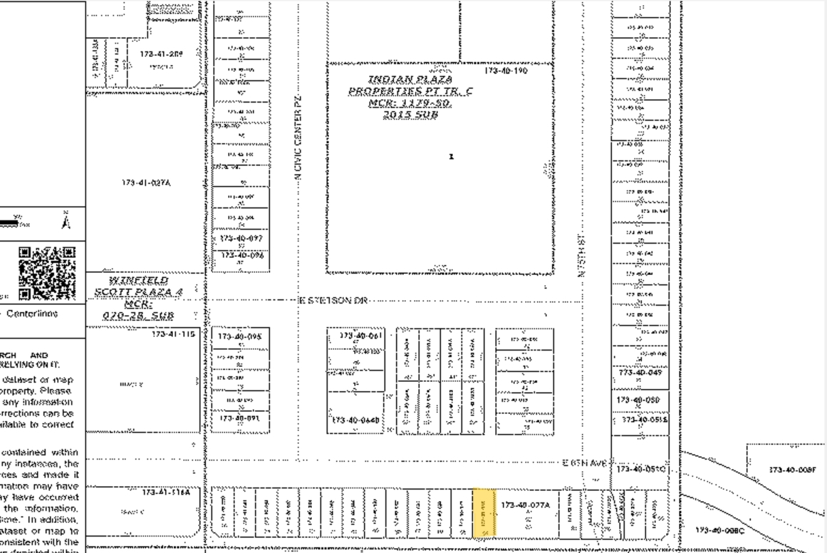
Indian Plaza Properties
173-40-078
INDIAN PLAZA PROPERTIES
Commercialacreage
Maricopa
X
Arizona
04013C2235M
64
2024
0.05 AC
2025
Scottsdale South
217201
Phoenix
DEMOGRAPHICS near 7431 E 6Th Ave
1 Mile
3 Mile
5 Mile
2024 Total Population
28,264
107,993
210,030
2029 Population
31,979
119,428
231,194
Pop Growth 2024-2029
+ 13.14%
+ 10.59%
+ 10.08%
Average Age
43
42
41
2024 Total Households
16,865
54,198
100,306
HH Growth 2024-2029
+ 13.20%
+ 10.87%
+ 10.32%
Median Household Inc
$78,784
$87,334
$81,501
Avg Household Size
1.60
1.90
2.00
2024 Avg HH Vehicles
1.00
2.00
2.00
Median Home Value
$491,162
$496,743
$554,142
Median Year Built
1987
1977
1978
Nearby Places
- Restaurants
- Banks
- Shops
- Fitness
- Groceries
PUBLIC TRANSPORTATION
AIRPORT
Phoenix Sky Harbor International
DRIVE
WALK
Distance
Phoenix Sky Harbor International
17 min
9.5 mi
Phoenix-Mesa Gateway
DRIVE
WALK
Distance
Phoenix-Mesa Gateway
41 min
28.0 mi
Freight Ports
Port of San Diego
DRIVE
WALK
Distance
Port of San Diego
411 min
366.1 mi
SALE & LEASE HISTORY
LISTING DATE
SALE/LEASE

Feb 16, 2021
For Sale
Nearby Properties
Address
Land Use
TOTAL SIZE
Lot Size
Zoning
Address
Land Use
TOTAL SIZE
Lot Size
Zoning
2,636,740 SF
21.88 AC
C-DT
Address
Land Use
TOTAL SIZE
Lot Size
Zoning
1,457,213 SF
41.78 AC
PUD
Address
Land Use
TOTAL SIZE
Lot Size
Zoning
1,870,689 SF
125.63 AC
I-P
Address
Land Use
TOTAL SIZE
Lot Size
Zoning
3,010 SF
35.44 AC
R110
Address
Land Use
TOTAL SIZE
Lot Size
Zoning
307,604 SF
37.83 AC
R-7
Address
Land Use
TOTAL SIZE
Lot Size
Zoning
776,898 SF
27.32 AC
C-R
Address
Land Use
TOTAL SIZE
Lot Size
Zoning
1,229,384 SF
4.81 AC
Address
Land Use
TOTAL SIZE
Lot Size
Zoning
457,979 SF
9.26 AC
CO
Address
Land Use
TOTAL SIZE
Lot Size
Zoning
392,172 SF
7.50 AC
DM2
Address
Land Use
TOTAL SIZE
Lot Size
Zoning
62,497 SF
130.73 AC
R-6
Address
Land Use
TOTAL SIZE
Lot Size
Zoning
439,600 SF
8.52 AC
DDCC2
Address
Land Use
TOTAL SIZE
Lot Size
Zoning
617,776 SF
4.53 AC
DDMU2
Address
Land Use
TOTAL SIZE
Lot Size
Zoning
639,643 SF
5.42 AC
PAD
Address
Land Use
TOTAL SIZE
Lot Size
Zoning
289,633 SF
9.11 AC
R-10
Address
Land Use
TOTAL SIZE
Lot Size
Zoning
530,384 SF
5.24 AC
C-DT
Address
Land Use
TOTAL SIZE
Lot Size
Zoning
590,903 SF
9.41 AC
C-DT
Address
Land Use
TOTAL SIZE
Lot Size
Zoning
438,373 SF
11.35 AC
Address
Land Use
TOTAL SIZE
Lot Size
Zoning
245,175 SF
6.94 AC
DDRU2
Address
Land Use
TOTAL SIZE
Lot Size
Zoning
153,890 SF
8.54 AC
C-R
Address
Land Use
TOTAL SIZE
Lot Size
Zoning
514,973 SF
4.14 AC
DDMU2
Address
Land Use
TOTAL SIZE
Lot Size
Zoning
355,399 SF
7.13 AC
C-C
Address
Land Use
TOTAL SIZE
Lot Size
Zoning
153,300 SF
8.78 AC
R5
Address
Land Use
TOTAL SIZE
Lot Size
Zoning
346,932 SF
5.11 AC
PC
Address
Land Use
TOTAL SIZE
Lot Size
Zoning
745,394 SF
14.34 AC
PUD
Address
Land Use
TOTAL SIZE
Lot Size
Zoning
251,592 SF
3.81 AC
PUD
Address
Land Use
TOTAL SIZE
Lot Size
Zoning
121,740 SF
22.13 AC
SUPR
Address
Land Use
TOTAL SIZE
Lot Size
Zoning
333,888 SF
7.36 AC
PUD
Address
Land Use
TOTAL SIZE
Lot Size
Zoning
262,260 SF
8.79 AC
R-18
Address
Land Use
TOTAL SIZE
Lot Size
Zoning
489,367 SF
4.39 AC
PUD
The World's #1 Commercial Real Estate Marketplace
Connect with us
© 2025 CoStar Group
The information above has been obtained from sources believed reliable. While we do not doubt its accuracy we have not verified it and make no guarantee, warranty or representation about it. It is your responsibility to independently confirm its accuracy and completeness. Any projections, opinions, assumptions, or estimates used are for example only and do not represent the current or future performance of the property. The value of this transaction to you depends on tax and other factors which should be evaluated by your tax, financial, and legal advisors. You and your advisors should conduct a careful, independent investigation of the property to determine to your satisfaction the suitability of the property for your needs.