Property Record
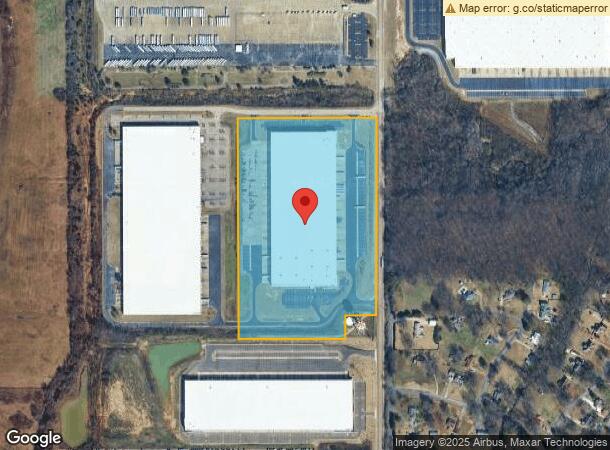
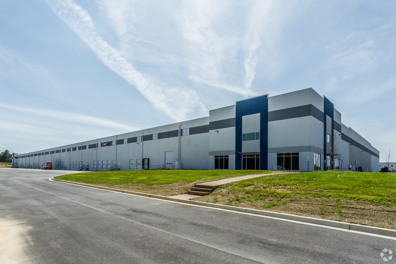
7437 Polk Ln, Olive Branch, MS 38654

Current Lease Availabilities
NEARBY LISTINGS FOR SALE OR LEASE
Property Detail
7437 Polk Ln
Memphis, TN-MS-AR
Obp Industrial Park
1067251300000200
OBP INDUSTRIAL PARK LOT 2
Commercialnec
DeSoto
X
Mississippi
28033C0110H
2
2024
28.15 AC
2024
DeSoto
070830
Memphis
413,488 SF
DEMOGRAPHICS near 7437 Polk Ln
1 Mile
3 Mile
5 Mile
2024 Total Population
563
25,205
77,406
2029 Population
608
26,942
79,815
Pop Growth 2024-2029
+ 7.99%
+ 6.89%
+ 3.11%
Average Age
37
37
38
2024 Total Households
187
9,224
28,059
HH Growth 2024-2029
+ 8.02%
+ 6.79%
+ 3.01%
Median Household Inc
$104,452
$75,743
$80,981
Avg Household Size
3.00
2.70
2.70
2024 Avg HH Vehicles
2.00
2.00
2.00
Median Home Value
$258,181
$212,814
$221,593
Median Year Built
2004
1998
1997
Nearby Places
- Restaurants
- Banks
- Shops
- Fitness
- Groceries
PUBLIC TRANSPORTATION
AIRPORT
Memphis International
DRIVE
WALK
Distance
Memphis International
26 min
16.8 mi
Freight Ports
Port of Shreveport
DRIVE
WALK
Distance
Port of Shreveport
430 min
390.6 mi
Nearby Properties
Address
Land Use
TOTAL SIZE
Lot Size
Zoning
Address
Land Use
TOTAL SIZE
Lot Size
Zoning
1,063,915 SF
74.33 AC
M-2
Address
Land Use
TOTAL SIZE
Lot Size
Zoning
830,732 SF
41.14 AC
M-1
Address
Land Use
TOTAL SIZE
Lot Size
Zoning
1,151,180 SF
68.41 AC
M-1
Address
Land Use
TOTAL SIZE
Lot Size
Zoning
990,181 SF
55.79 AC
M-1
Address
Land Use
TOTAL SIZE
Lot Size
Zoning
1,103,356 SF
60.98 AC
M-1
Address
Land Use
TOTAL SIZE
Lot Size
Zoning
869,876 SF
43.85 AC
M-1
Address
Land Use
TOTAL SIZE
Lot Size
Zoning
616,255 SF
39.07 AC
M-1
Address
Land Use
TOTAL SIZE
Lot Size
Zoning
1,299,800 SF
50.22 AC
M-1
Address
Land Use
TOTAL SIZE
Lot Size
Zoning
642,804 SF
67.55 AC
M-1
Address
Land Use
TOTAL SIZE
Lot Size
Zoning
728,940 SF
66.85 AC
M-1
Address
Land Use
TOTAL SIZE
Lot Size
Zoning
928,416 SF
42.73 AC
PB
Address
Land Use
TOTAL SIZE
Lot Size
Zoning
814,637 SF
38.72 AC
PB
Address
Land Use
TOTAL SIZE
Lot Size
Zoning
617,288 SF
61.92 AC
PUD
Address
Land Use
TOTAL SIZE
Lot Size
Zoning
426,759 SF
40.66 AC
M-1
Address
Land Use
TOTAL SIZE
Lot Size
Zoning
1,085,489 SF
57.74 AC
PB
Address
Land Use
TOTAL SIZE
Lot Size
Zoning
861,020 SF
43.13 AC
M-1
Address
Land Use
TOTAL SIZE
Lot Size
Zoning
81,018 SF
18.09 AC
CA
Address
Land Use
TOTAL SIZE
Lot Size
Zoning
28.41 AC
PB
Address
Land Use
TOTAL SIZE
Lot Size
Zoning
69,571 SF
16.22 AC
CA
Address
Land Use
TOTAL SIZE
Lot Size
Zoning
606,459 SF
40.17 AC
M-1
Address
Land Use
TOTAL SIZE
Lot Size
Zoning
596,400 SF
43.20 AC
M-2
Address
Land Use
TOTAL SIZE
Lot Size
Zoning
400,185 SF
19.97 AC
M-1
Address
Land Use
TOTAL SIZE
Lot Size
Zoning
430,422 SF
21.24 AC
M-1
Address
Land Use
TOTAL SIZE
Lot Size
Zoning
340,555 SF
28.56 AC
M-2
Address
Land Use
TOTAL SIZE
Lot Size
Zoning
27,669 SF
34.27 AC
R-4
Address
Land Use
TOTAL SIZE
Lot Size
Zoning
480,000 SF
23.80 AC
M-2
Address
Land Use
TOTAL SIZE
Lot Size
Zoning
415,360 SF
30.18 AC
M-1
Address
Land Use
TOTAL SIZE
Lot Size
Zoning
22.08 AC
PB
Address
Land Use
TOTAL SIZE
Lot Size
Zoning
391,111 SF
18.22 AC
M-1
The World's #1 Commercial Real Estate Marketplace
Connect with us
© 2025 CoStar Group
The information above has been obtained from sources believed reliable. While we do not doubt its accuracy we have not verified it and make no guarantee, warranty or representation about it. It is your responsibility to independently confirm its accuracy and completeness. Any projections, opinions, assumptions, or estimates used are for example only and do not represent the current or future performance of the property. The value of this transaction to you depends on tax and other factors which should be evaluated by your tax, financial, and legal advisors. You and your advisors should conduct a careful, independent investigation of the property to determine to your satisfaction the suitability of the property for your needs.