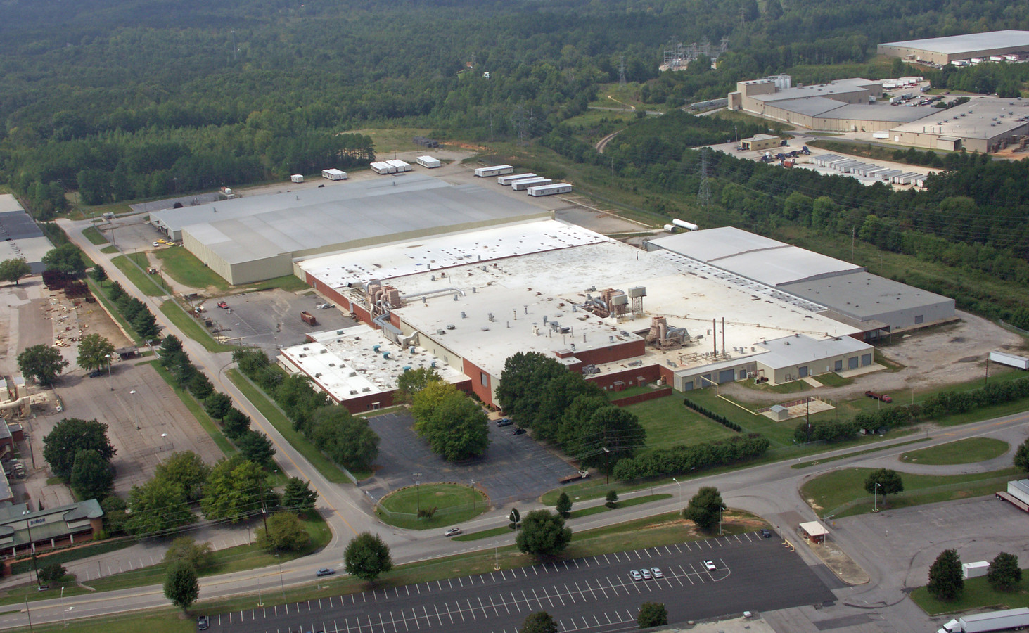
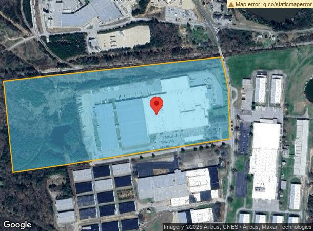
Property Record
745 Kentuck Rd, Danville, VA 24540
NEARBY LISTINGS FOR SALE OR LEASE
Property Detail
745 Kentuck Rd
73505
66.18 AC PT NO E-1 KENTUCK RD
Manufacturinglight
Danville City
X
Virginia
51143C0652E
66.18 AC
2024
Virginia South Central
2024
Other Market Areas
001301
Danville, VA
833,039 SF
DEMOGRAPHICS near 745 Kentuck Rd
1 Mile
3 Mile
5 Mile
2024 Total Population
787
11,524
37,557
2029 Population
764
11,465
37,276
Pop Growth 2024-2029
(2.92%)
(0.51%)
(0.75%)
Average Age
44
42
43
2024 Total Households
395
5,013
16,599
HH Growth 2024-2029
(3.04%)
(0.60%)
(0.75%)
Median Household Inc
$36,166
$30,192
$38,018
Avg Household Size
2.00
2.20
2.10
2024 Avg HH Vehicles
2.00
1.00
2.00
Median Home Value
$121,818
$77,009
$98,267
Median Year Built
1973
1961
1963
Nearby Places
- Restaurants
- Banks
- Shops
- Fitness
- Groceries
PUBLIC TRANSPORTATION
COMMUTER RAIL
Danville Amtrak Station (Crescent - Amtrak)
DRIVE
WALK
Distance
Danville Amtrak Station (Crescent - Amtrak)
9 min
4.9 mi
Freight Ports
Virginia Port Authority - Richmond
DRIVE
WALK
Distance
Virginia Port Authority - Richmond
183 min
139.5 mi
Nearby Properties
Address
Land Use
TOTAL SIZE
Lot Size
Zoning
Address
Land Use
TOTAL SIZE
Lot Size
Zoning
87.04 AC
M-1
Address
Land Use
TOTAL SIZE
Lot Size
Zoning
23.16 AC
M-1
Address
Land Use
TOTAL SIZE
Lot Size
Zoning
1,440 SF
75.14 AC
LIGHT ECON
Address
Land Use
TOTAL SIZE
Lot Size
Zoning
485,973 SF
135.71 AC
MANUFACTUR
Address
Land Use
TOTAL SIZE
Lot Size
Zoning
66,846 SF
22.99 AC
CYBER PARK
Address
Land Use
TOTAL SIZE
Lot Size
Zoning
23.30 AC
M-1
Address
Land Use
TOTAL SIZE
Lot Size
Zoning
48,285 SF
3.76 AC
TOBACCO WA
Address
Land Use
TOTAL SIZE
Lot Size
Zoning
7,554 SF
961.50 AC
LIGHT ECON
Address
Land Use
TOTAL SIZE
Lot Size
Zoning
2,421 SF
14.29 AC
LIGHT ECON
Address
Land Use
TOTAL SIZE
Lot Size
Zoning
241,200 SF
55.54 AC
M-1
Address
Land Use
TOTAL SIZE
Lot Size
Zoning
205,652 SF
7.12 AC
LIGHT ECON
Address
Land Use
TOTAL SIZE
Lot Size
Zoning
312,528 SF
23.32 AC
M-1
Address
Land Use
TOTAL SIZE
Lot Size
Zoning
102,314 SF
1.17 AC
TOBACCO WA
Address
Land Use
TOTAL SIZE
Lot Size
Zoning
41,664 SF
1.56 AC
TOBACCO WA
Address
Land Use
TOTAL SIZE
Lot Size
Zoning
93,442 SF
11.94 AC
CYBER PARK
Address
Land Use
TOTAL SIZE
Lot Size
Zoning
66,954 SF
17.70 AC
TOBACCO WA
Address
Land Use
TOTAL SIZE
Lot Size
Zoning
420 SF
40.78 AC
LIGHT ECON
Address
Land Use
TOTAL SIZE
Lot Size
Zoning
33,748 SF
3.73 AC
TOBACCO WA
Address
Land Use
TOTAL SIZE
Lot Size
Zoning
51.53 AC
M-1
Address
Land Use
TOTAL SIZE
Lot Size
Zoning
6,664 SF
102.20 AC
MANUFACTUR
Address
Land Use
TOTAL SIZE
Lot Size
Zoning
162 SF
87 AC
HIGHWAY RE
Address
Land Use
TOTAL SIZE
Lot Size
Zoning
87,704 SF
1.70 AC
TOBACCO WA
Address
Land Use
TOTAL SIZE
Lot Size
Zoning
68,160 SF
0.85 AC
TOBACCO WA
Address
Land Use
TOTAL SIZE
Lot Size
Zoning
25.05 AC
M-2
Address
Land Use
TOTAL SIZE
Lot Size
Zoning
43,352 SF
5.59 AC
TRANSITION
Address
Land Use
TOTAL SIZE
Lot Size
Zoning
150,127 SF
18.97 AC
TRANSITION
Address
Land Use
TOTAL SIZE
Lot Size
Zoning
77,004 SF
22.58 AC
THRESHOLD
Address
Land Use
TOTAL SIZE
Lot Size
Zoning
73,944 SF
0.70 AC
TOBACCO WA
The World's #1 Commercial Real Estate Marketplace
Connect with us
© 2025 CoStar Group
The information above has been obtained from sources believed reliable. While we do not doubt its accuracy we have not verified it and make no guarantee, warranty or representation about it. It is your responsibility to independently confirm its accuracy and completeness. Any projections, opinions, assumptions, or estimates used are for example only and do not represent the current or future performance of the property. The value of this transaction to you depends on tax and other factors which should be evaluated by your tax, financial, and legal advisors. You and your advisors should conduct a careful, independent investigation of the property to determine to your satisfaction the suitability of the property for your needs.