Property Record
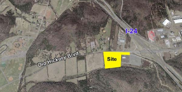
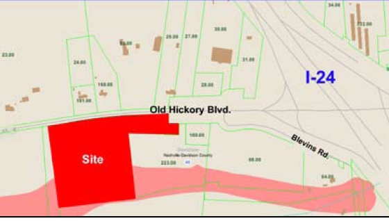
7450 Old Hickory Blvd, Whites Creek, TN 37189
NEARBY LISTINGS FOR SALE OR LEASE
Property Detail
7450 Old Hickory Blvd
Nashville-Davidson--Murfreesboro--Franklin, TN
Little Creek Farm Section One
040-00-0-170
S SIDE OLD HICKORY BOULEVARD, E OF WHITES CREEK PIKE
Parkinglot
Davidson
AE
Tennessee
47147C0475D
7.35 AC
2024
West
2024
Nashville
010104
DEMOGRAPHICS near 7450 Old Hickory Blvd
1 Mile
3 Mile
5 Mile
2024 Total Population
370
12,369
53,977
2029 Population
374
12,281
53,976
Pop Growth 2024-2029
+ 1.08%
(0.71%)
0.00%
Average Age
41
40
40
2024 Total Households
138
4,533
21,123
HH Growth 2024-2029
0.00%
(1.04%)
(0.28%)
Median Household Inc
$79,412
$66,132
$54,510
Avg Household Size
2.60
2.60
2.40
2024 Avg HH Vehicles
2.00
2.00
2.00
Median Home Value
$287,499
$279,406
$291,011
Median Year Built
2000
1990
1981
Nearby Places
- Restaurants
- Banks
- Shops
- Fitness
- Groceries
PUBLIC TRANSPORTATION
COMMUTER RAIL
Riverfront (East Corridor Line - Tennessee Regional Transportation Authority Music City Star (Music City Star))
DRIVE
WALK
Distance
Riverfront (East Corridor Line - Tennessee Regional Transportation Authority Music City Star (Music City Star))
13 min
9.5 mi
AIRPORT
Nashville International
DRIVE
WALK
Distance
Nashville International
23 min
17.2 mi
Freight Ports
Port of Mobile
DRIVE
WALK
Distance
Port of Mobile
495 min
454.7 mi
Nearby Properties
Address
Land Use
TOTAL SIZE
Lot Size
Zoning
Address
Land Use
TOTAL SIZE
Lot Size
Zoning
14,024 SF
MULTIZONE
Address
Land Use
TOTAL SIZE
Lot Size
Zoning
511,019 SF
38.69 AC
MULTIZONE
Address
Land Use
TOTAL SIZE
Lot Size
Zoning
29,625 SF
14.48 AC
R10
Address
Land Use
TOTAL SIZE
Lot Size
Zoning
195,176 SF
13.75 AC
MULTIZONE
Address
Land Use
TOTAL SIZE
Lot Size
Zoning
31,405 SF
3.86 AC
SP
Address
Land Use
TOTAL SIZE
Lot Size
Zoning
13,250 SF
25 AC
SP
Address
Land Use
TOTAL SIZE
Lot Size
Zoning
33,214 SF
8.40 AC
R20
Address
Land Use
TOTAL SIZE
Lot Size
Zoning
30,896 SF
11.75 AC
RS7.5
Address
Land Use
TOTAL SIZE
Lot Size
Zoning
62,181 SF
10.25 AC
R20
Address
Land Use
TOTAL SIZE
Lot Size
Zoning
42,009 SF
5.73 AC
R10
Address
Land Use
TOTAL SIZE
Lot Size
Zoning
3,840 SF
9.17 AC
CS
Address
Land Use
TOTAL SIZE
Lot Size
Zoning
14,280 SF
5.69 AC
OR20
Address
Land Use
TOTAL SIZE
Lot Size
Zoning
8,192 SF
15 AC
MULTIZONE
Address
Land Use
TOTAL SIZE
Lot Size
Zoning
7,200 SF
5.28 AC
RS15
Address
Land Use
TOTAL SIZE
Lot Size
Zoning
9,324 SF
17 AC
R10
Address
Land Use
TOTAL SIZE
Lot Size
Zoning
11,954 SF
4.94 AC
IWD
Address
Land Use
TOTAL SIZE
Lot Size
Zoning
14,324 SF
96.22 AC
MULTIZONE
Address
Land Use
TOTAL SIZE
Lot Size
Zoning
14,736 SF
1.63 AC
CS
Address
Land Use
TOTAL SIZE
Lot Size
Zoning
32,128 SF
10.17 AC
RS20
Address
Land Use
TOTAL SIZE
Lot Size
Zoning
15,375 SF
8.76 AC
R10
Address
Land Use
TOTAL SIZE
Lot Size
Zoning
9,840 SF
9.49 AC
AR2A
Address
Land Use
TOTAL SIZE
Lot Size
Zoning
20,025 SF
2.40 AC
CS
Address
Land Use
TOTAL SIZE
Lot Size
Zoning
18,876 SF
2.80 AC
CS
Address
Land Use
TOTAL SIZE
Lot Size
Zoning
55,320 SF
3.86 AC
OR20
Address
Land Use
TOTAL SIZE
Lot Size
Zoning
4,140 SF
27.69 AC
RS20
Address
Land Use
TOTAL SIZE
Lot Size
Zoning
11,149 SF
10.25 AC
SP
Address
Land Use
TOTAL SIZE
Lot Size
Zoning
5,340 SF
8.93 AC
MULTIZONE
Address
Land Use
TOTAL SIZE
Lot Size
Zoning
4,997 SF
1.98 AC
CL
Address
Land Use
TOTAL SIZE
Lot Size
Zoning
3,916 SF
5.40 AC
OR20
Address
Land Use
TOTAL SIZE
Lot Size
Zoning
5,400 SF
4.17 AC
OR20
The World's #1 Commercial Real Estate Marketplace
Connect with us
© 2025 CoStar Group
The information above has been obtained from sources believed reliable. While we do not doubt its accuracy we have not verified it and make no guarantee, warranty or representation about it. It is your responsibility to independently confirm its accuracy and completeness. Any projections, opinions, assumptions, or estimates used are for example only and do not represent the current or future performance of the property. The value of this transaction to you depends on tax and other factors which should be evaluated by your tax, financial, and legal advisors. You and your advisors should conduct a careful, independent investigation of the property to determine to your satisfaction the suitability of the property for your needs.