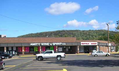
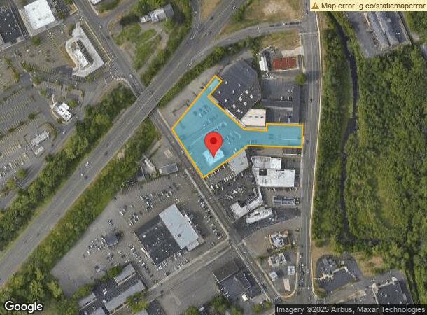
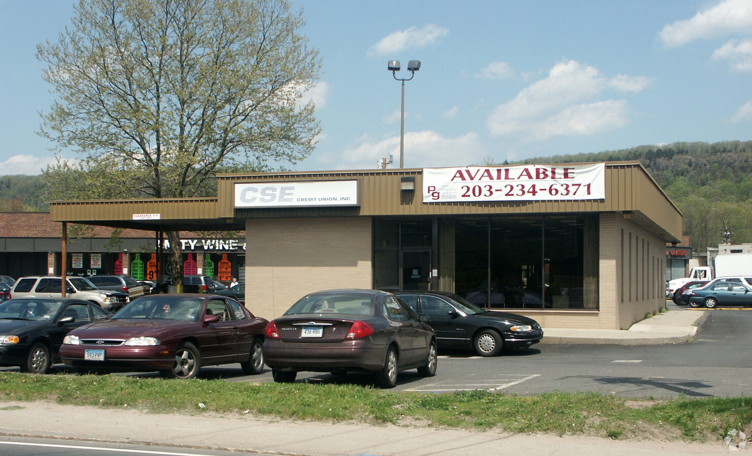
Property Record
75 Amity Rd, New Haven, CT 06515

NEARBY LISTINGS FOR SALE OR LEASE
Property Detail
75 Amity Rd
NHVN-000429-001173-000302
New Haven
Commercialnec
Connecticut
X
302
09009C0428H
1.69 AC
2024
New Haven
2024
Westchester/So Connecticut
141200
New Haven-Milford, CT
25,549 SF
DEMOGRAPHICS near 75 Amity Rd
1 Mile
3 Mile
5 Mile
2024 Total Population
9,365
83,426
213,455
2029 Population
9,285
82,608
211,643
Pop Growth 2024-2029
(0.85%)
(0.98%)
(0.85%)
Average Age
39
37
37
2024 Total Households
3,818
30,654
82,280
HH Growth 2024-2029
(0.92%)
(1.13%)
(0.82%)
Median Household Inc
$67,031
$58,243
$65,107
Avg Household Size
2.40
2.40
2.30
2024 Avg HH Vehicles
2.00
1.00
1.00
Median Home Value
$242,640
$254,244
$267,780
Median Year Built
1954
1950
1955
Nearby Places
- Restaurants
- Banks
- Shops
- Fitness
- Groceries
PUBLIC TRANSPORTATION
COMMUTER RAIL
New Haven-State Street Station (New Haven Line - Shore Line East, Shore Line East - Shore Line East)
DRIVE
WALK
Distance
New Haven-State Street Station (New Haven Line - Shore Line East, Shore Line East - Shore Line East)
8 min
4.0 mi
New Haven (New Haven - Metro-North Railroad)
DRIVE
WALK
Distance
New Haven (New Haven - Metro-North Railroad)
8 min
4.6 mi
AIRPORT
Tweed/New Haven
DRIVE
WALK
Distance
Tweed/New Haven
17 min
8.9 mi
Freight Ports
Port of New Haven
DRIVE
WALK
Distance
Port of New Haven
12 min
6.1 mi
Nearby Properties
Address
Land Use
TOTAL SIZE
Lot Size
Zoning
Address
Land Use
TOTAL SIZE
Lot Size
Zoning
347,604 SF
6.37 AC
RM2
Address
Land Use
TOTAL SIZE
Lot Size
Zoning
302,262 SF
10.40 AC
RM1
Address
Land Use
TOTAL SIZE
Lot Size
Zoning
111,274 SF
22.62 AC
RM1
Address
Land Use
TOTAL SIZE
Lot Size
Zoning
9,767 SF
33.63 AC
RM1
Address
Land Use
TOTAL SIZE
Lot Size
Zoning
316,781 SF
9.20 AC
PARK
Address
Land Use
TOTAL SIZE
Lot Size
Zoning
57,339 SF
3.46 AC
RM2
Address
Land Use
TOTAL SIZE
Lot Size
Zoning
54,372 SF
2.42 AC
RM2
Address
Land Use
TOTAL SIZE
Lot Size
Zoning
75,139 SF
3.54 AC
RM1
Address
Land Use
TOTAL SIZE
Lot Size
Zoning
158,622 SF
2.09 AC
BA
Address
Land Use
TOTAL SIZE
Lot Size
Zoning
6,784 SF
17.53 AC
RM1
Address
Land Use
TOTAL SIZE
Lot Size
Zoning
73,504 SF
7.97 AC
IL
Address
Land Use
TOTAL SIZE
Lot Size
Zoning
43,673 SF
4.84 AC
BB
Address
Land Use
TOTAL SIZE
Lot Size
Zoning
34,373 SF
4.57 AC
RM2
Address
Land Use
TOTAL SIZE
Lot Size
Zoning
57,918 SF
0.49 AC
RH2
Address
Land Use
TOTAL SIZE
Lot Size
Zoning
78,579 SF
6.07 AC
RM2
Address
Land Use
TOTAL SIZE
Lot Size
Zoning
8,758 SF
12.74 AC
IH
Address
Land Use
TOTAL SIZE
Lot Size
Zoning
91,976 SF
0.11 AC
BA
Address
Land Use
TOTAL SIZE
Lot Size
Zoning
4,334 SF
70 AC
RS2
Address
Land Use
TOTAL SIZE
Lot Size
Zoning
119,187 SF
1.38 AC
RO
Address
Land Use
TOTAL SIZE
Lot Size
Zoning
152,220 SF
13.08 AC
T4
Address
Land Use
TOTAL SIZE
Lot Size
Zoning
25,015 SF
28.30 AC
RS2
Address
Land Use
TOTAL SIZE
Lot Size
Zoning
26,560 SF
4.22 AC
RM2
Address
Land Use
TOTAL SIZE
Lot Size
Zoning
92,126 SF
4.32 AC
RM2
Address
Land Use
TOTAL SIZE
Lot Size
Zoning
576 SF
RS2
Address
Land Use
TOTAL SIZE
Lot Size
Zoning
46,962 SF
1.48 AC
RM1
Address
Land Use
TOTAL SIZE
Lot Size
Zoning
86,644 SF
14 AC
PARK
Address
Land Use
TOTAL SIZE
Lot Size
Zoning
25 AC
A
Address
Land Use
TOTAL SIZE
Lot Size
Zoning
167,547 SF
Address
Land Use
TOTAL SIZE
Lot Size
Zoning
124,090 SF
2 AC
RH2
Address
Land Use
TOTAL SIZE
Lot Size
Zoning
55,880 SF
8.56 AC
RM2
The World's #1 Commercial Real Estate Marketplace
Connect with us
© 2025 CoStar Group
The information above has been obtained from sources believed reliable. While we do not doubt its accuracy we have not verified it and make no guarantee, warranty or representation about it. It is your responsibility to independently confirm its accuracy and completeness. Any projections, opinions, assumptions, or estimates used are for example only and do not represent the current or future performance of the property. The value of this transaction to you depends on tax and other factors which should be evaluated by your tax, financial, and legal advisors. You and your advisors should conduct a careful, independent investigation of the property to determine to your satisfaction the suitability of the property for your needs.