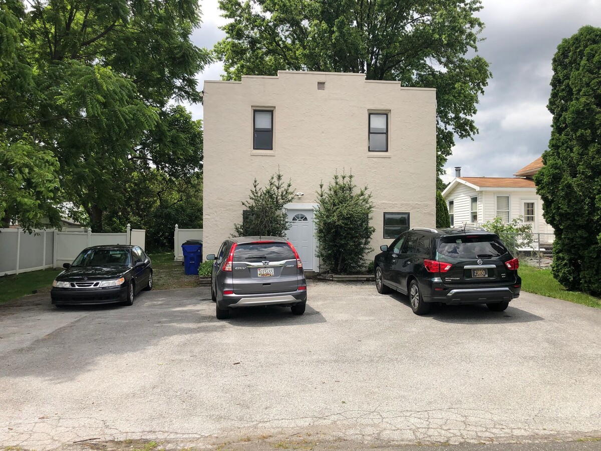
Property Record
7505 Governor Printz Blvd, Claymont, DE 19703

NEARBY LISTINGS FOR SALE OR LEASE
Property Detail
7505 Governor Printz Blvd
06-107.00-013
Rolling Park
Officebuilding
New Castle
X
Delaware
10003C0087L
15
2024
0.17 AC
2024
North New Castle County
010104
Philadelphia
1,872 SF
Philadelphia-Camden-Wilmington, PA-NJ-DE-MD
DEMOGRAPHICS near 7505 Governor Printz Blvd
1 Mile
3 Mile
5 Mile
2024 Total Population
10,751
52,778
151,618
2029 Population
10,894
53,337
153,137
Pop Growth 2024-2029
+ 1.33%
+ 1.06%
+ 1.00%
Average Age
40
42
42
2024 Total Households
4,458
22,215
60,654
HH Growth 2024-2029
+ 1.39%
+ 1.08%
+ 1.02%
Median Household Inc
$65,449
$80,793
$74,788
Avg Household Size
2.30
2.30
2.40
2024 Avg HH Vehicles
2.00
2.00
2.00
Median Home Value
$248,360
$312,105
$306,373
Median Year Built
1958
1962
1962
Nearby Places
- Restaurants
- Banks
- Shops
- Fitness
- Groceries
PUBLIC TRANSPORTATION
COMMUTER RAIL
Claymont (R2 - Southeastern Pennsylvania Transportation Authority Regional Rail (SEPTA Regional Rail))
DRIVE
WALK
Distance
Claymont (R2 - Southeastern Pennsylvania Transportation Authority Regional Rail (SEPTA Regional Rail))
6 min
2.3 mi
Marcus Hook (R2 - Southeastern Pennsylvania Transportation Authority Regional Rail (SEPTA Regional Rail))
DRIVE
WALK
Distance
Marcus Hook (R2 - Southeastern Pennsylvania Transportation Authority Regional Rail (SEPTA Regional Rail))
9 min
4.3 mi
AIRPORT
Philadelphia International
DRIVE
WALK
Distance
Philadelphia International
24 min
15.3 mi
Freight Ports
Port of Wilmington, RI
DRIVE
WALK
Distance
Port of Wilmington, RI
13 min
7.6 mi
SALE & LEASE HISTORY
LISTING DATE
SALE/LEASE

Jul 01, 2020
For Sale
Jan 17, 2023
For Sale
Nearby Properties
Address
Land Use
TOTAL SIZE
Lot Size
Zoning
Address
Land Use
TOTAL SIZE
Lot Size
Zoning
26,424 SF
341 AC
Address
Land Use
TOTAL SIZE
Lot Size
Zoning
15,880 SF
27.07 AC
Address
Land Use
TOTAL SIZE
Lot Size
Zoning
109,145 SF
10.57 AC
S
Address
Land Use
TOTAL SIZE
Lot Size
Zoning
205,529 SF
42.34 AC
S
Address
Land Use
TOTAL SIZE
Lot Size
Zoning
131,812 SF
20.70 AC
Address
Land Use
TOTAL SIZE
Lot Size
Zoning
197,332 SF
12.13 AC
S
Address
Land Use
TOTAL SIZE
Lot Size
Zoning
122,819 SF
21.23 AC
S
Address
Land Use
TOTAL SIZE
Lot Size
Zoning
231,920 SF
23.52 AC
S
Address
Land Use
TOTAL SIZE
Lot Size
Zoning
212,522 SF
16.04 AC
OR
Address
Land Use
TOTAL SIZE
Lot Size
Zoning
240,690 SF
18.44 AC
NCAP
Address
Land Use
TOTAL SIZE
Lot Size
Zoning
132,400 SF
7.79 AC
OR
Address
Land Use
TOTAL SIZE
Lot Size
Zoning
166,216 SF
5.01 AC
NCAP
Address
Land Use
TOTAL SIZE
Lot Size
Zoning
244,483 SF
10.01 AC
OR
Address
Land Use
TOTAL SIZE
Lot Size
Zoning
111,655 SF
50.62 AC
OR
Address
Land Use
TOTAL SIZE
Lot Size
Zoning
141,066 SF
36.52 AC
S
Address
Land Use
TOTAL SIZE
Lot Size
Zoning
210,681 SF
36.36 AC
CR
Address
Land Use
TOTAL SIZE
Lot Size
Zoning
324,733 SF
17.70 AC
NCAP
Address
Land Use
TOTAL SIZE
Lot Size
Zoning
54,000 SF
9.58 AC
Address
Land Use
TOTAL SIZE
Lot Size
Zoning
212,990 SF
13.69 AC
S
Address
Land Use
TOTAL SIZE
Lot Size
Zoning
297,108 SF
5.74 AC
NCAP
Address
Land Use
TOTAL SIZE
Lot Size
Zoning
393,718 SF
42.16 AC
NCGA
Address
Land Use
TOTAL SIZE
Lot Size
Zoning
99,418 SF
7.17 AC
OR
Address
Land Use
TOTAL SIZE
Lot Size
Zoning
32.12 AC
Address
Land Use
TOTAL SIZE
Lot Size
Zoning
128,737 SF
5.44 AC
CR
Address
Land Use
TOTAL SIZE
Lot Size
Zoning
282,932 SF
20.12 AC
NCAP
Address
Land Use
TOTAL SIZE
Lot Size
Zoning
86,916 SF
24.70 AC
S
Address
Land Use
TOTAL SIZE
Lot Size
Zoning
1,467 SF
89.30 AC
Address
Land Use
TOTAL SIZE
Lot Size
Zoning
71,400 SF
3.65 AC
OR
Address
Land Use
TOTAL SIZE
Lot Size
Zoning
72,024 SF
24.55 AC
S
Address
Land Use
TOTAL SIZE
Lot Size
Zoning
232,890 SF
4.30 AC
NCAP
The World's #1 Commercial Real Estate Marketplace
Connect with us
© 2025 CoStar Group
The information above has been obtained from sources believed reliable. While we do not doubt its accuracy we have not verified it and make no guarantee, warranty or representation about it. It is your responsibility to independently confirm its accuracy and completeness. Any projections, opinions, assumptions, or estimates used are for example only and do not represent the current or future performance of the property. The value of this transaction to you depends on tax and other factors which should be evaluated by your tax, financial, and legal advisors. You and your advisors should conduct a careful, independent investigation of the property to determine to your satisfaction the suitability of the property for your needs.