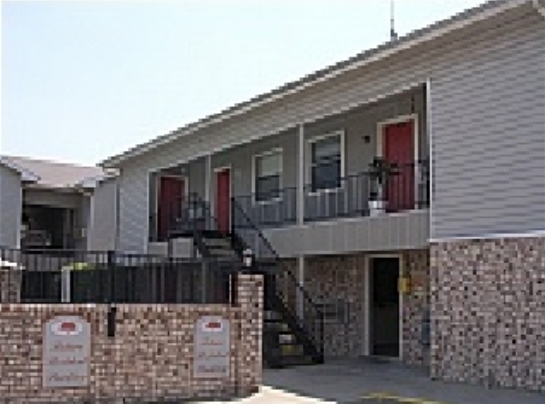
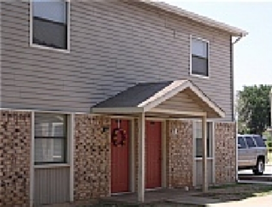
Property Record
7510 Nw Tango Rd, Lawton, OK 73505
NEARBY LISTINGS FOR SALE OR LEASE
-
-
View all Lawton listings for sale on LoopNet.com
Property Detail
7510 Nw Tango Rd
Lawton, OK
Terrace Hills
0020783
TERRACE HILLS BLK 1 LOT 1
Apartment
Comanche
X
Oklahoma
40031C0263E
1
2024
2.75 AC
2023
Oklahoma West Area
000402
Other Market Areas
3,366 SF
DEMOGRAPHICS near 7510 Nw Tango Rd
1 Mile
3 Mile
5 Mile
2024 Total Population
5,602
32,865
64,325
2029 Population
5,770
33,715
66,487
Pop Growth 2024-2029
+ 3.00%
+ 2.59%
+ 3.36%
Average Age
41
38
37
2024 Total Households
2,299
13,434
25,473
HH Growth 2024-2029
+ 2.91%
+ 2.62%
+ 3.44%
Median Household Inc
$58,078
$51,344
$46,603
Avg Household Size
2.20
2.40
2.40
2024 Avg HH Vehicles
2.00
2.00
2.00
Median Home Value
$177,433
$166,080
$143,053
Median Year Built
1981
1977
1973
Nearby Places
- Restaurants
- Banks
- Shops
- Fitness
- Groceries
PUBLIC TRANSPORTATION
AIRPORT
Lawton-Fort Sill Regional
Drive
Walk
Distance
Lawton-Fort Sill Regional
16 min
7.9 mi
Freight Ports
Tulsa Port Of Catoosa
Drive
Walk
Distance
Tulsa Port Of Catoosa
229 min
213.1 mi
Nearby Properties
Address
Land Use
TOTAL SIZE
Lot Size
Zoning
Address
Land Use
TOTAL SIZE
Lot Size
Zoning
55256
6.30 AC
Address
Land Use
TOTAL SIZE
Lot Size
Zoning
17400
25.35 AC
Address
Land Use
TOTAL SIZE
Lot Size
Zoning
30000
17.22 AC
Address
Land Use
TOTAL SIZE
Lot Size
Zoning
76116
30.05 AC
Address
Land Use
TOTAL SIZE
Lot Size
Zoning
1488
19.43 AC
Address
Land Use
TOTAL SIZE
Lot Size
Zoning
13326
8.47 AC
Address
Land Use
TOTAL SIZE
Lot Size
Zoning
906
5.51 AC
Address
Land Use
TOTAL SIZE
Lot Size
Zoning
2330
19.42 AC
Address
Land Use
TOTAL SIZE
Lot Size
Zoning
131736
10.23 AC
Address
Land Use
TOTAL SIZE
Lot Size
Zoning
39546
10.62 AC
Address
Land Use
TOTAL SIZE
Lot Size
Zoning
39791
20.50 AC
Address
Land Use
TOTAL SIZE
Lot Size
Zoning
83945
46.95 AC
Address
Land Use
TOTAL SIZE
Lot Size
Zoning
25800
3.82 AC
Address
Land Use
TOTAL SIZE
Lot Size
Zoning
68844
10.42 AC
Address
Land Use
TOTAL SIZE
Lot Size
Zoning
3349
1.30 AC
Address
Land Use
TOTAL SIZE
Lot Size
Zoning
117301
13.82 AC
Address
Land Use
TOTAL SIZE
Lot Size
Zoning
3470
10.11 AC
Address
Land Use
TOTAL SIZE
Lot Size
Zoning
63224
2.66 AC
Address
Land Use
TOTAL SIZE
Lot Size
Zoning
9240
6.43 AC
Address
Land Use
TOTAL SIZE
Lot Size
Zoning
65320
4.80 AC
Address
Land Use
TOTAL SIZE
Lot Size
Zoning
3366
5.97 AC
Address
Land Use
TOTAL SIZE
Lot Size
Zoning
82509
6.29 AC
Address
Land Use
TOTAL SIZE
Lot Size
Zoning
36063
6.35 AC
Address
Land Use
TOTAL SIZE
Lot Size
Zoning
7960
0.58 AC
Address
Land Use
TOTAL SIZE
Lot Size
Zoning
52491
7.66 AC
Address
Land Use
TOTAL SIZE
Lot Size
Zoning
29498
8.02 AC
Address
Land Use
TOTAL SIZE
Lot Size
Zoning
2376
8.64 AC
Address
Land Use
TOTAL SIZE
Lot Size
Zoning
55965
10.72 AC
Address
Land Use
TOTAL SIZE
Lot Size
Zoning
3366
4.70 AC
Address
Land Use
TOTAL SIZE
Lot Size
Zoning
4000
3 AC
Start a new search to find other properties for sale or lease
Connect with us
© 2024 CoStar Group
The information above has been obtained from sources believed reliable. While we do not doubt its accuracy we have not verified it and make no guarantee, warranty or representation about it. It is your responsibility to independently confirm its accuracy and completeness. Any projections, opinions, assumptions, or estimates used are for example only and do not represent the current or future performance of the property. The value of this transaction to you depends on tax and other factors which should be evaluated by your tax, financial, and legal advisors. You and your advisors should conduct a careful, independent investigation of the property to determine to your satisfaction the suitability of the property for your needs.