No Photo
Property Record
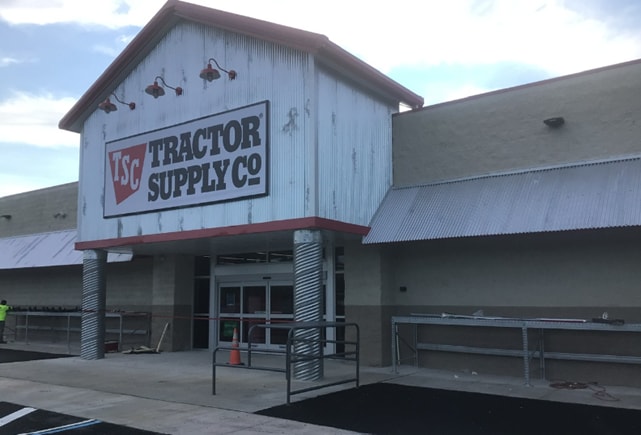
7633 Se Us Highway 301, Hawthorne, FL 32640


NEARBY LISTINGS FOR SALE OR LEASE
-
-
View all Hawthorne listings for sale on LoopNet.com
Property Detail
7633 Se Us Highway 301
19923-001-000
Capstone Quarters
Departmentstore
COM AT THE ELY R/W LINE OF HIGHWAY 301 AND S LINE OF NW1/4 OF NW1/4 POB RUN NELY ALONG R/W 665.43 FT S 84 DEG E 309.79 FT TO W R/W OF SE2ND ST S 14 DEG E ALONG W R/W 624.31 FT S 87 DEG W 712.89 FT TO POB (LESS COM SW COR NW 1/4 N 01 DEG 10 MIN 41 SEC
X
Alachua
12001C0505D
Florida
2025
5.86 AC
2025
Gainesville
002002
Other Market Areas
21,156 SF
Gainesville, FL
DEMOGRAPHICS near 7633 Se Us Highway 301
1 Mile
3 Mile
5 Mile
2024 Total Population
951
2,723
5,357
2029 Population
1,002
2,881
5,675
Pop Growth 2024-2029
+ 5.36%
+ 5.80%
+ 5.94%
Average Age
42
44
45
2024 Total Households
366
1,088
2,213
HH Growth 2024-2029
+ 5.74%
+ 6.07%
+ 6.06%
Median Household Inc
$50,185
$46,298
$42,562
Avg Household Size
2.60
2.50
2.40
2024 Avg HH Vehicles
2.00
2.00
2.00
Median Home Value
$144,298
$148,062
$150,927
Median Year Built
1976
1981
1982
Nearby Places
Map Layers
Map Styles
 Street
 Aerial
- Restaurants
- Banks
- Shops
- Fitness
- Groceries
PUBLIC TRANSPORTATION
AIRPORT
Gainesville Regional
DRIVE
WALK
Distance
Gainesville Regional
30 min
19.8 mi
Freight Ports
Jacksonville Port
DRIVE
WALK
Distance
Jacksonville Port
97 min
76.5 mi
SALE & LEASE HISTORY
LISTING DATE
SALE/LEASE

Sep 28, 2022
For Sale
Aug 07, 2023
For Sale
Nearby Properties
Address
Land Use
TOTAL SIZE
Lot Size
Zoning
Address
Land Use
TOTAL SIZE
Lot Size
Zoning
411,296 SF
31.62 AC
RSF2
Address
Land Use
TOTAL SIZE
Lot Size
Zoning
52,762 SF
8.47 AC
RSF2
Address
Land Use
TOTAL SIZE
Lot Size
Zoning
55,849 SF
7.74 AC
CG
Address
Land Use
TOTAL SIZE
Lot Size
Zoning
10,854 SF
5.22 AC
CIW
Address
Land Use
TOTAL SIZE
Lot Size
Zoning
20,258 SF
10.13 AC
RSF2
Address
Land Use
TOTAL SIZE
Lot Size
Zoning
11,986 SF
1.59 AC
CG
Address
Land Use
TOTAL SIZE
Lot Size
Zoning
4,419 SF
72.21 AC
Address
Land Use
TOTAL SIZE
Lot Size
Zoning
21,000 SF
1.80 AC
CIW
Address
Land Use
TOTAL SIZE
Lot Size
Zoning
1,613 SF
39.70 AC
A
Address
Land Use
TOTAL SIZE
Lot Size
Zoning
17,760 SF
1.34 AC
RSF2
Address
Land Use
TOTAL SIZE
Lot Size
Zoning
19,180 SF
2.13 AC
I
Address
Land Use
TOTAL SIZE
Lot Size
Zoning
2,315 SF
6.38 AC
RSF2
Address
Land Use
TOTAL SIZE
Lot Size
Zoning
4,636 SF
0.31 AC
CG
Address
Land Use
TOTAL SIZE
Lot Size
Zoning
4,929 SF
2.52 AC
CG
Address
Land Use
TOTAL SIZE
Lot Size
Zoning
6,060 SF
9.97 AC
I
Address
Land Use
TOTAL SIZE
Lot Size
Zoning
5,520 SF
0.55 AC
CCBD
Address
Land Use
TOTAL SIZE
Lot Size
Zoning
8,804 SF
0.68 AC
RSF1
Address
Land Use
TOTAL SIZE
Lot Size
Zoning
12,000 SF
5.16 AC
CIW
Address
Land Use
TOTAL SIZE
Lot Size
Zoning
3,200 SF
34.51 AC
A
Address
Land Use
TOTAL SIZE
Lot Size
Zoning
4,963 SF
0.65 AC
IL
Address
Land Use
TOTAL SIZE
Lot Size
Zoning
5,550 SF
40.45 AC
A
Address
Land Use
TOTAL SIZE
Lot Size
Zoning
5,041 SF
0.45 AC
CCBD
Address
Land Use
TOTAL SIZE
Lot Size
Zoning
80 AC
A
Address
Land Use
TOTAL SIZE
Lot Size
Zoning
10,716 SF
1.13 AC
CG
Address
Land Use
TOTAL SIZE
Lot Size
Zoning
38.36 AC
Address
Land Use
TOTAL SIZE
Lot Size
Zoning
9,443 SF
1.36 AC
RMF1
Address
Land Use
TOTAL SIZE
Lot Size
Zoning
6,352 SF
0.87 AC
CCBD
Address
Land Use
TOTAL SIZE
Lot Size
Zoning
6,936 SF
0.95 AC
CG
Address
Land Use
TOTAL SIZE
Lot Size
Zoning
3,560 SF
1.72 AC
CIW
The World's #1 Commercial Real Estate Marketplace
Connect with us
© 2026 CoStar Group
The information above has been obtained from sources believed reliable. While we do not doubt its accuracy we have not verified it and make no guarantee, warranty or representation about it. It is your responsibility to independently confirm its accuracy and completeness. Any projections, opinions, assumptions, or estimates used are for example only and do not represent the current or future performance of the property. The value of this transaction to you depends on tax and other factors which should be evaluated by your tax, financial, and legal advisors. You and your advisors should conduct a careful, independent investigation of the property to determine to your satisfaction the suitability of the property for your needs.