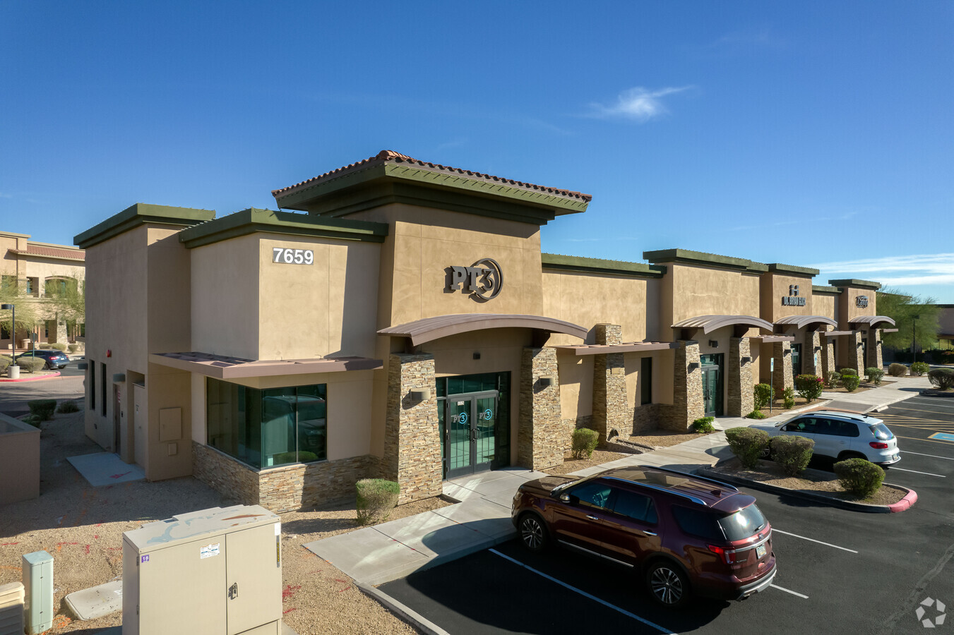
Property Record
7659 E Pinnacle Peak Rd, Scottsdale, AZ 85255
Current Lease Availabilities
NEARBY LISTINGS FOR SALE OR LEASE
Property Detail
7659 E Pinnacle Peak Rd
Phoenix-Mesa-Scottsdale, AZ
Peaks Corporate Park 2 Condominium
212-03-544
PEAKS CORPORATE PARK 2 CONDOMINIUM MCR 1002-18 UNIT 105 BLDG E (PLEASE NOTE: FOR LEGAL DESCRIPTION REFERENCES REGARDING THE PERCENTAGE OF OWNERSHIP OF THE COMMON AREA(S) PLEASE REFER TO THE RECORDED COVENANTS, CONDITIONS AND RESTRICTIONS (CCR) ASSOCI
Officecondo
Maricopa
X
Arizona
04013C1310M
105
2024
0.06 AC
2025
N Scottsdale/Carefree
216841
Phoenix
10,016 SF
DEMOGRAPHICS near 7659 E Pinnacle Peak Rd
1 Mile
3 Mile
5 Mile
2024 Total Population
7,196
30,584
109,583
2029 Population
7,865
33,765
120,858
Pop Growth 2024-2029
+ 9.30%
+ 10.40%
+ 10.29%
Average Age
47
47
45
2024 Total Households
2,986
13,826
47,461
HH Growth 2024-2029
+ 9.38%
+ 10.75%
+ 10.71%
Median Household Inc
$128,852
$122,323
$126,495
Avg Household Size
2.30
2.20
2.30
2024 Avg HH Vehicles
2.00
2.00
2.00
Median Home Value
$737,469
$798,655
$751,617
Median Year Built
1998
2001
1999
Nearby Places
- Restaurants
- Banks
- Shops
- Fitness
- Groceries
PUBLIC TRANSPORTATION
AIRPORT
Phoenix Sky Harbor International
DRIVE
WALK
Distance
Phoenix Sky Harbor International
37 min
26.0 mi
Freight Ports
Port of San Diego
DRIVE
WALK
Distance
Port of San Diego
425 min
378.1 mi
Nearby Properties
Address
Land Use
TOTAL SIZE
Lot Size
Zoning
Address
Land Use
TOTAL SIZE
Lot Size
Zoning
1,479,005 SF
12.55 AC
PC
Address
Land Use
TOTAL SIZE
Lot Size
Zoning
229,856 SF
7.71 AC
C-T
Address
Land Use
TOTAL SIZE
Lot Size
Zoning
734,840 SF
33.12 AC
M-H
Address
Land Use
TOTAL SIZE
Lot Size
Zoning
487,786 SF
18.42 AC
S1
Address
Land Use
TOTAL SIZE
Lot Size
Zoning
90.73 AC
O-S
Address
Land Use
TOTAL SIZE
Lot Size
Zoning
67.59 AC
C-C
Address
Land Use
TOTAL SIZE
Lot Size
Zoning
525,073 SF
8.51 AC
R4
Address
Land Use
TOTAL SIZE
Lot Size
Zoning
255,313 SF
22.54 AC
PNC
Address
Land Use
TOTAL SIZE
Lot Size
Zoning
385,376 SF
13.65 AC
PAD
Address
Land Use
TOTAL SIZE
Lot Size
Zoning
702,652 SF
4.58 AC
Address
Land Use
TOTAL SIZE
Lot Size
Zoning
375,257 SF
12 AC
M-H
Address
Land Use
TOTAL SIZE
Lot Size
Zoning
41.63 AC
I-1
Address
Land Use
TOTAL SIZE
Lot Size
Zoning
240,187 SF
14.26 AC
S1
Address
Land Use
TOTAL SIZE
Lot Size
Zoning
731,843 SF
29.85 AC
M-H
Address
Land Use
TOTAL SIZE
Lot Size
Zoning
328,616 SF
10.56 AC
PAD
Address
Land Use
TOTAL SIZE
Lot Size
Zoning
397,568 SF
16.71 AC
PAD
Address
Land Use
TOTAL SIZE
Lot Size
Zoning
163,122 SF
8.63 AC
C-C
Address
Land Use
TOTAL SIZE
Lot Size
Zoning
373,066 SF
13 AC
M-H
Address
Land Use
TOTAL SIZE
Lot Size
Zoning
58.66 AC
R-43AG
Address
Land Use
TOTAL SIZE
Lot Size
Zoning
161,955 SF
2.65 AC
Address
Land Use
TOTAL SIZE
Lot Size
Zoning
157,340 SF
4.40 AC
PC
Address
Land Use
TOTAL SIZE
Lot Size
Zoning
570.07 AC
R-43
Address
Land Use
TOTAL SIZE
Lot Size
Zoning
286,776 SF
5.86 AC
C-T
Address
Land Use
TOTAL SIZE
Lot Size
Zoning
201,308 SF
3.44 AC
PC
Address
Land Use
TOTAL SIZE
Lot Size
Zoning
66,317 SF
20.82 AC
R-190
Address
Land Use
TOTAL SIZE
Lot Size
Zoning
115,275 SF
12.16 AC
C-C
Address
Land Use
TOTAL SIZE
Lot Size
Zoning
100,378 SF
12.29 AC
C-C
Address
Land Use
TOTAL SIZE
Lot Size
Zoning
80,105 SF
12.35 AC
PAD
Address
Land Use
TOTAL SIZE
Lot Size
Zoning
311,819 SF
3.84 AC
R4
Address
Land Use
TOTAL SIZE
Lot Size
Zoning
77,580 SF
9.84 AC
R-7
The World's #1 Commercial Real Estate Marketplace
Connect with us
© 2025 CoStar Group
The information above has been obtained from sources believed reliable. While we do not doubt its accuracy we have not verified it and make no guarantee, warranty or representation about it. It is your responsibility to independently confirm its accuracy and completeness. Any projections, opinions, assumptions, or estimates used are for example only and do not represent the current or future performance of the property. The value of this transaction to you depends on tax and other factors which should be evaluated by your tax, financial, and legal advisors. You and your advisors should conduct a careful, independent investigation of the property to determine to your satisfaction the suitability of the property for your needs.