Property Record
767 Battlefield Pkwy, Fort Oglethorpe, GA 30742
NEARBY LISTINGS FOR SALE OR LEASE
Property Detail
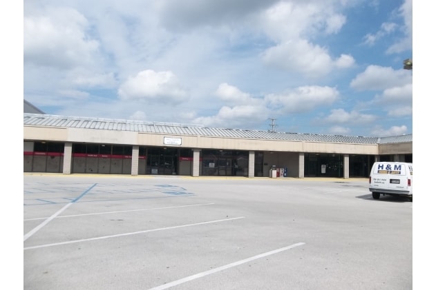
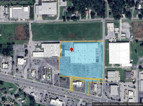
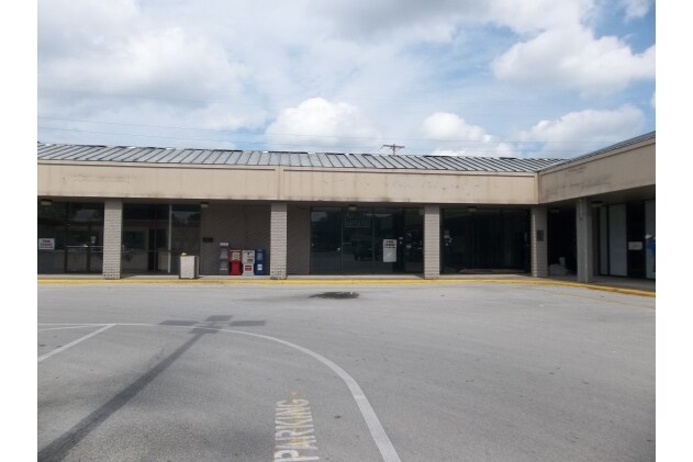
767 Battlefield Pkwy
0003B-007
Com- Battlefield Pkwy- Fort O
Stripcommercialcenter
PARKWAY VILLAGE GABES, ORCHARD CHURCH
X
Catoosa
13047C0009E
Georgia
2024
7.35 AC
2024
Catoosa County
030701
Chattanooga
106,602 SF
Chattanooga, TN-GA
DEMOGRAPHICS near 767 Battlefield Pkwy
1 Mile
3 Mile
5 Mile
2024 Total Population
7,506
40,276
100,264
2029 Population
7,708
41,902
105,331
Pop Growth 2024-2029
+ 2.69%
+ 4.04%
+ 5.05%
Average Age
42
42
40
2024 Total Households
3,131
16,721
40,267
HH Growth 2024-2029
+ 2.68%
+ 4.06%
+ 5.09%
Median Household Inc
$47,033
$46,620
$45,783
Avg Household Size
2.30
2.30
2.40
2024 Avg HH Vehicles
2.00
2.00
2.00
Median Home Value
$159,457
$145,608
$165,060
Median Year Built
1971
1969
1968
Nearby Places
Map Layers
Map Styles
 Street
 Aerial
- Restaurants
- Banks
- Shops
- Fitness
- Groceries
PUBLIC TRANSPORTATION
AIRPORT
Lovell Field
DRIVE
WALK
Distance
Lovell Field
21 min
7.7 mi
Freight Ports
Georgia Ports - Savannah
DRIVE
WALK
Distance
Georgia Ports - Savannah
399 min
357.3 mi
SALE & LEASE HISTORY
LISTING DATE
SALE/LEASE

Sep 25, 2016
For Lease
Sep 24, 2016
For Sale
Jul 28, 2017
For Lease
Nearby Properties
Address
Land Use
TOTAL SIZE
Lot Size
Zoning
Address
Land Use
TOTAL SIZE
Lot Size
Zoning
72,340 SF
105.70 AC
FOR
Address
Land Use
TOTAL SIZE
Lot Size
Zoning
54,026 SF
17.89 AC
FOR R-3
Address
Land Use
TOTAL SIZE
Lot Size
Zoning
17,742 SF
8 AC
FOR PM
Address
Land Use
TOTAL SIZE
Lot Size
Zoning
133,447 SF
17.65 AC
FOR C-2
Address
Land Use
TOTAL SIZE
Lot Size
Zoning
90,565 SF
18.50 AC
FOR R-2
Address
Land Use
TOTAL SIZE
Lot Size
Zoning
2,172 SF
13.95 AC
FOR R-3
Address
Land Use
TOTAL SIZE
Lot Size
Zoning
1,326 SF
13.62 AC
FOR
Address
Land Use
TOTAL SIZE
Lot Size
Zoning
2,210 SF
11.33 AC
FOR R-5
Address
Land Use
TOTAL SIZE
Lot Size
Zoning
168,883 SF
14.88 AC
FOR C-2
Address
Land Use
TOTAL SIZE
Lot Size
Zoning
58,911 SF
12.37 AC
FOR C-2
Address
Land Use
TOTAL SIZE
Lot Size
Zoning
5,100 SF
13.10 AC
FOR
Address
Land Use
TOTAL SIZE
Lot Size
Zoning
130,515 SF
18.78 AC
FOR C-1
Address
Land Use
TOTAL SIZE
Lot Size
Zoning
41,872 SF
7.09 AC
C2
Address
Land Use
TOTAL SIZE
Lot Size
Zoning
101,298 SF
14 AC
FOR
Address
Land Use
TOTAL SIZE
Lot Size
Zoning
196,132 SF
25.97 AC
FOR C-2
Address
Land Use
TOTAL SIZE
Lot Size
Zoning
87,796 SF
3.15 AC
FOR C-2
Address
Land Use
TOTAL SIZE
Lot Size
Zoning
4,700 SF
9.80 AC
R-1
Address
Land Use
TOTAL SIZE
Lot Size
Zoning
63,406 SF
9.81 AC
SZ
Address
Land Use
TOTAL SIZE
Lot Size
Zoning
4,096 SF
4.96 AC
FOR PM
Address
Land Use
TOTAL SIZE
Lot Size
Zoning
42,928 SF
7.78 AC
FOR
Address
Land Use
TOTAL SIZE
Lot Size
Zoning
51,309 SF
5.77 AC
FOR
Address
Land Use
TOTAL SIZE
Lot Size
Zoning
2,400 SF
6.25 AC
FOR PM
Address
Land Use
TOTAL SIZE
Lot Size
Zoning
60,240 SF
6.38 AC
FOR C-2
Address
Land Use
TOTAL SIZE
Lot Size
Zoning
36,616 SF
4.27 AC
FOR I-1
Address
Land Use
TOTAL SIZE
Lot Size
Zoning
24,156 SF
7.58 AC
R3
Address
Land Use
TOTAL SIZE
Lot Size
Zoning
63,216 SF
2.91 AC
C2
Address
Land Use
TOTAL SIZE
Lot Size
Zoning
47,845 SF
4.22 AC
FOR
Address
Land Use
TOTAL SIZE
Lot Size
Zoning
51,724 SF
4.08 AC
Address
Land Use
TOTAL SIZE
Lot Size
Zoning
5,856 SF
6.51 AC
FOR R-3
The World's #1 Commercial Real Estate Marketplace
Connect with us
© 2026 CoStar Group
The information above has been obtained from sources believed reliable. While we do not doubt its accuracy we have not verified it and make no guarantee, warranty or representation about it. It is your responsibility to independently confirm its accuracy and completeness. Any projections, opinions, assumptions, or estimates used are for example only and do not represent the current or future performance of the property. The value of this transaction to you depends on tax and other factors which should be evaluated by your tax, financial, and legal advisors. You and your advisors should conduct a careful, independent investigation of the property to determine to your satisfaction the suitability of the property for your needs.