Property Record
77 Us Highway 206, Stanhope, NJ 07874
NEARBY LISTINGS FOR SALE OR LEASE
Property Detail
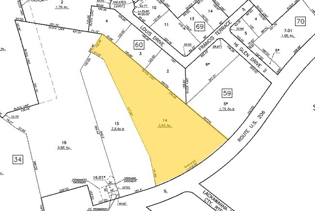
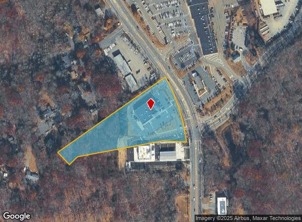
77 Us Highway 206
04-00034-0000-00014
Sussex
Storebuilding
New Jersey
X
14
34037C0412E
3.92 AC
2024
Sussex County
2025
Northern New Jersey
374600
Newark, NJ-PA
6,757 SF
DEMOGRAPHICS near 77 Us Highway 206
1 Mile
3 Mile
5 Mile
2024 Total Population
1,802
21,642
57,639
2029 Population
1,825
21,891
58,275
Pop Growth 2024-2029
+ 1.28%
+ 1.15%
+ 1.10%
Average Age
42
42
42
2024 Total Households
666
8,549
22,512
HH Growth 2024-2029
+ 1.35%
+ 1.23%
+ 1.12%
Median Household Inc
$107,031
$95,426
$100,200
Avg Household Size
2.70
2.50
2.50
2024 Avg HH Vehicles
2.00
2.00
2.00
Median Home Value
$314,844
$283,688
$333,985
Median Year Built
1970
1966
1970
Nearby Places
Map Layers
Map Styles
 Street
 Aerial
- Restaurants
- Banks
- Shops
- Fitness
- Groceries
PUBLIC TRANSPORTATION
COMMUTER RAIL
Mount Olive (Montclair-Boonton Line - NJ Transit Commuter Rail (NJ Transit), Morris & Essex Morristown Line - NJ Transit Commuter Rail (NJ Transit))
DRIVE
WALK
Distance
Mount Olive (Montclair-Boonton Line - NJ Transit Commuter Rail (NJ Transit), Morris & Essex Morristown Line - NJ Transit Commuter Rail (NJ Transit))
4 min
2.4 mi
Netcong (Montclair-Boonton Line - NJ Transit Commuter Rail (NJ Transit), Morris & Essex Morristown Line - NJ Transit Commuter Rail (NJ Transit))
DRIVE
WALK
Distance
Netcong (Montclair-Boonton Line - NJ Transit Commuter Rail (NJ Transit), Morris & Essex Morristown Line - NJ Transit Commuter Rail (NJ Transit))
5 min
2.8 mi
Freight Ports
Maher Terminal
DRIVE
WALK
Distance
Maher Terminal
55 min
42.5 mi
Nearby Properties
Address
Land Use
TOTAL SIZE
Lot Size
Zoning
Address
Land Use
TOTAL SIZE
Lot Size
Zoning
977,550 SF
97.50 AC
FTZ4
Address
Land Use
TOTAL SIZE
Lot Size
Zoning
280,960 SF
46.25 AC
R-4
Address
Land Use
TOTAL SIZE
Lot Size
Zoning
44.67 AC
R2
Address
Land Use
TOTAL SIZE
Lot Size
Zoning
412,816 SF
40.48 AC
FTZ2
Address
Land Use
TOTAL SIZE
Lot Size
Zoning
48.48 AC
MLR
Address
Land Use
TOTAL SIZE
Lot Size
Zoning
5.19 AC
FTZ3
Address
Land Use
TOTAL SIZE
Lot Size
Zoning
228 SF
30.95 AC
L-I
Address
Land Use
TOTAL SIZE
Lot Size
Zoning
11.13 AC
FTZ1
Address
Land Use
TOTAL SIZE
Lot Size
Zoning
249,480 SF
5.66 AC
FTZ1
Address
Land Use
TOTAL SIZE
Lot Size
Zoning
13.63 AC
FTZ4
Address
Land Use
TOTAL SIZE
Lot Size
Zoning
207,196 SF
13.94 AC
L-I
Address
Land Use
TOTAL SIZE
Lot Size
Zoning
185,975 SF
18.20 AC
FTZ2
Address
Land Use
TOTAL SIZE
Lot Size
Zoning
248,940 SF
22.06 AC
FTZ2
Address
Land Use
TOTAL SIZE
Lot Size
Zoning
220,912 SF
56.21 AC
FTZ1
Address
Land Use
TOTAL SIZE
Lot Size
Zoning
19.87 AC
VB
Address
Land Use
TOTAL SIZE
Lot Size
Zoning
173,500 SF
12.38 AC
FTZ2
Address
Land Use
TOTAL SIZE
Lot Size
Zoning
89.81 AC
R-2
Address
Land Use
TOTAL SIZE
Lot Size
Zoning
27.96 AC
R2
Address
Land Use
TOTAL SIZE
Lot Size
Zoning
136,388 SF
22.58 AC
FTZ2
Address
Land Use
TOTAL SIZE
Lot Size
Zoning
157,672 SF
25.36 AC
I-3
Address
Land Use
TOTAL SIZE
Lot Size
Zoning
26.53 AC
R-5
Address
Land Use
TOTAL SIZE
Lot Size
Zoning
122,640 SF
10 AC
FTZ2
Address
Land Use
TOTAL SIZE
Lot Size
Zoning
85,136 SF
9.01 AC
FTZ4
Address
Land Use
TOTAL SIZE
Lot Size
Zoning
14.93 AC
R2
Address
Land Use
TOTAL SIZE
Lot Size
Zoning
115,536 SF
2.70 AC
FTZ2
Address
Land Use
TOTAL SIZE
Lot Size
Zoning
40,710 SF
3.88 AC
R-2
Address
Land Use
TOTAL SIZE
Lot Size
Zoning
8,034 SF
17.18 AC
P
Address
Land Use
TOTAL SIZE
Lot Size
Zoning
119,280 SF
7.98 AC
FTZ1
Address
Land Use
TOTAL SIZE
Lot Size
Zoning
19.19 AC
R-2
Address
Land Use
TOTAL SIZE
Lot Size
Zoning
75,772 SF
8.06 AC
FTZ1
The World's #1 Commercial Real Estate Marketplace
Connect with us
© 2026 CoStar Group
The information above has been obtained from sources believed reliable. While we do not doubt its accuracy we have not verified it and make no guarantee, warranty or representation about it. It is your responsibility to independently confirm its accuracy and completeness. Any projections, opinions, assumptions, or estimates used are for example only and do not represent the current or future performance of the property. The value of this transaction to you depends on tax and other factors which should be evaluated by your tax, financial, and legal advisors. You and your advisors should conduct a careful, independent investigation of the property to determine to your satisfaction the suitability of the property for your needs.