Property Record
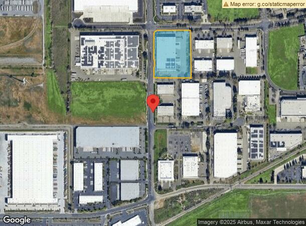
770 Chadbourne Rd, Fairfield, CA 94534
NEARBY LISTINGS FOR SALE OR LEASE
Property Detail
770 Chadbourne Rd
Vallejo-Fairfield, CA
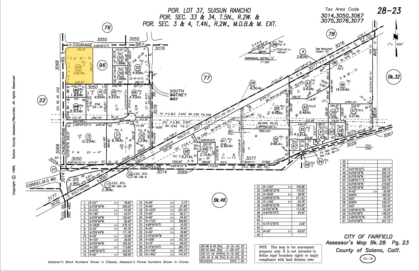
Parcel Map Of A Subdivision Of Parcel A
0028-230-530
BK-BG 45-74 LOT A
Warehouse
Solano
X
California
06095C0452F
a
2023
5.87 AC
2023
Fairfield
252402
North Bay/Santa Rosa
92,567 SF
DEMOGRAPHICS near 770 Chadbourne Rd
1 Mile
3 Mile
5 Mile
2024 Total Population
1,742
32,753
112,749
2029 Population
1,719
32,281
111,188
Pop Growth 2024-2029
(1.32%)
(1.44%)
(1.38%)
Average Age
39
39
39
2024 Total Households
521
11,050
37,371
HH Growth 2024-2029
(1.34%)
(1.41%)
(1.43%)
Median Household Inc
$93,258
$81,717
$87,662
Avg Household Size
3.10
2.90
2.90
2024 Avg HH Vehicles
3.00
2.00
2.00
Median Home Value
$444,360
$520,544
$523,776
Median Year Built
1983
1977
1981
Nearby Places
- Restaurants
- Banks
- Shops
- Fitness
- Groceries
PUBLIC TRANSPORTATION
COMMUTER RAIL
Suisun-Fairfield (Capitol Corridor - Capitol Corridor Joint Powers Authority)
DRIVE
WALK
Distance
Suisun-Fairfield (Capitol Corridor - Capitol Corridor Joint Powers Authority)
5 min
3.3 mi
Fairfield-Vacaville (Capitol Corridor - Amtrak)
DRIVE
WALK
Distance
Fairfield-Vacaville (Capitol Corridor - Amtrak)
14 min
9.4 mi
Freight Ports
Port of Richmond
DRIVE
WALK
Distance
Port of Richmond
45 min
34.2 mi
Nearby Properties
Address
Land Use
TOTAL SIZE
Lot Size
Zoning
Address
Land Use
TOTAL SIZE
Lot Size
Zoning
75.45 AC
Address
Land Use
TOTAL SIZE
Lot Size
Zoning
Address
Land Use
TOTAL SIZE
Lot Size
Zoning
317,493 SF
21.54 AC
Address
Land Use
TOTAL SIZE
Lot Size
Zoning
9,945 SF
51.21 AC
Address
Land Use
TOTAL SIZE
Lot Size
Zoning
Address
Land Use
TOTAL SIZE
Lot Size
Zoning
527,279 SF
33.29 AC
Address
Land Use
TOTAL SIZE
Lot Size
Zoning
204,928 SF
8.87 AC
MR
Address
Land Use
TOTAL SIZE
Lot Size
Zoning
22.49 AC
Address
Land Use
TOTAL SIZE
Lot Size
Zoning
430,500 SF
20.85 AC
Address
Land Use
TOTAL SIZE
Lot Size
Zoning
430,500 SF
15.70 AC
Address
Land Use
TOTAL SIZE
Lot Size
Zoning
290,560 SF
12.73 AC
Address
Land Use
TOTAL SIZE
Lot Size
Zoning
175,453 SF
8.03 AC
MULTI RES
Address
Land Use
TOTAL SIZE
Lot Size
Zoning
473,135 SF
24.25 AC
Address
Land Use
TOTAL SIZE
Lot Size
Zoning
23,820 SF
1.43 AC
Address
Land Use
TOTAL SIZE
Lot Size
Zoning
69,580 SF
12.67 AC
Address
Land Use
TOTAL SIZE
Lot Size
Zoning
210,567 SF
5.47 AC
Address
Land Use
TOTAL SIZE
Lot Size
Zoning
66,539 SF
6.61 AC
Address
Land Use
TOTAL SIZE
Lot Size
Zoning
10,140 SF
1.30 AC
Address
Land Use
TOTAL SIZE
Lot Size
Zoning
115,592 SF
4.97 AC
Address
Land Use
TOTAL SIZE
Lot Size
Zoning
318,402 SF
18.73 AC
Address
Land Use
TOTAL SIZE
Lot Size
Zoning
53,960 SF
8.22 AC
Address
Land Use
TOTAL SIZE
Lot Size
Zoning
7.82 AC
Address
Land Use
TOTAL SIZE
Lot Size
Zoning
Address
Land Use
TOTAL SIZE
Lot Size
Zoning
191,132 SF
9.01 AC
Address
Land Use
TOTAL SIZE
Lot Size
Zoning
59,427 SF
2.90 AC
Address
Land Use
TOTAL SIZE
Lot Size
Zoning
95,800 SF
8.95 AC
Address
Land Use
TOTAL SIZE
Lot Size
Zoning
348,271 SF
16.05 AC
Address
Land Use
TOTAL SIZE
Lot Size
Zoning
39,170 SF
4.33 AC
LT IND/COM
Address
Land Use
TOTAL SIZE
Lot Size
Zoning
1.92 AC
Address
Land Use
TOTAL SIZE
Lot Size
Zoning
64,863 SF
2.08 AC
COMML/MOT
The World's #1 Commercial Real Estate Marketplace
Connect with us
© 2025 CoStar Group
The information above has been obtained from sources believed reliable. While we do not doubt its accuracy we have not verified it and make no guarantee, warranty or representation about it. It is your responsibility to independently confirm its accuracy and completeness. Any projections, opinions, assumptions, or estimates used are for example only and do not represent the current or future performance of the property. The value of this transaction to you depends on tax and other factors which should be evaluated by your tax, financial, and legal advisors. You and your advisors should conduct a careful, independent investigation of the property to determine to your satisfaction the suitability of the property for your needs.