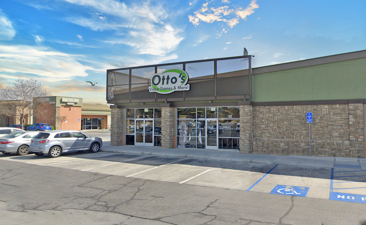
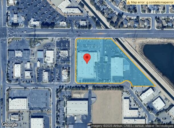
Property Record
7701 White Ln, Bakersfield, CA 93309
NEARBY LISTINGS FOR SALE OR LEASE
-
-
-
-
7801 Panama Lan SEQ Panama Lane & Wynnfield Lakes Lane Ln
Bakersfield, CA 93313
Negotiable
52,600 SF
Retail
-
-
-
-
View all Bakersfield listings for lease on LoopNet.com
Property Detail
7701 White Ln
Bakersfield, CA
Community Acres
385-013-05-00-5
PARCEL MAP 8096 , LOT 3
Storebuilding
Kern
X
California
06029C2300E
3
2023
7.30 AC
2024
Southwest Bakersfield
003131
Bakersfield
58,143 SF
DEMOGRAPHICS near 7701 White Ln
1 Mile
3 Mile
5 Mile
2024 Total Population
15,981
128,775
263,204
2029 Population
15,940
128,762
263,527
Pop Growth 2024-2029
(0.26%)
(0.01%)
+ 0.12%
Average Age
36
36
35
2024 Total Households
5,665
42,700
83,229
HH Growth 2024-2029
(0.23%)
(0.09%)
+ 0.08%
Median Household Inc
$72,502
$76,459
$71,890
Avg Household Size
2.80
2.90
3.10
2024 Avg HH Vehicles
2.00
2.00
2.00
Median Home Value
$279,462
$300,395
$296,313
Median Year Built
1986
1986
1985
Nearby Places
- Restaurants
- Banks
- Shops
- Fitness
- Groceries
PUBLIC TRANSPORTATION
COMMUTER RAIL
Bakersfield (San Joaquins - Amtrak)
DRIVE
WALK
Distance
Bakersfield (San Joaquins - Amtrak)
16 min
9.1 mi
AIRPORT
Meadows Field
DRIVE
WALK
Distance
Meadows Field
23 min
12.6 mi
Freight Ports
The Port of Hueneme
DRIVE
WALK
Distance
The Port of Hueneme
152 min
120.8 mi
SALE & LEASE HISTORY
LISTING DATE
SALE/LEASE

Mar 22, 2018
For Lease
Jan 10, 2018
For Lease
Feb 16, 2023
For Lease
Nearby Properties
Address
Land Use
TOTAL SIZE
Lot Size
Zoning
Address
Land Use
TOTAL SIZE
Lot Size
Zoning
587,976 SF
40.01 AC
M-2
Address
Land Use
TOTAL SIZE
Lot Size
Zoning
5,850 SF
10.96 AC
C2
Address
Land Use
TOTAL SIZE
Lot Size
Zoning
114,500 SF
12.02 AC
C-2
Address
Land Use
TOTAL SIZE
Lot Size
Zoning
354,000 SF
20 AC
M2
Address
Land Use
TOTAL SIZE
Lot Size
Zoning
14,529 SF
27.73 AC
R-2
Address
Land Use
TOTAL SIZE
Lot Size
Zoning
241,051 SF
18.48 AC
CO
Address
Land Use
TOTAL SIZE
Lot Size
Zoning
14,500 SF
33.82 AC
C2
Address
Land Use
TOTAL SIZE
Lot Size
Zoning
253,532 SF
14.69 AC
Address
Land Use
TOTAL SIZE
Lot Size
Zoning
269,429 SF
12.71 AC
R-2
Address
Land Use
TOTAL SIZE
Lot Size
Zoning
138,559 SF
11.92 AC
C-2 PCD
Address
Land Use
TOTAL SIZE
Lot Size
Zoning
71,922 SF
4.99 AC
CO
Address
Land Use
TOTAL SIZE
Lot Size
Zoning
15,027 SF
17.72 AC
C-2
Address
Land Use
TOTAL SIZE
Lot Size
Zoning
99,368 SF
6.95 AC
CO
Address
Land Use
TOTAL SIZE
Lot Size
Zoning
37,760 SF
12.16 AC
R3
Address
Land Use
TOTAL SIZE
Lot Size
Zoning
233,512 SF
9.19 AC
R-3
Address
Land Use
TOTAL SIZE
Lot Size
Zoning
214,746 SF
14.91 AC
Address
Land Use
TOTAL SIZE
Lot Size
Zoning
210,432 SF
13.52 AC
R-2
Address
Land Use
TOTAL SIZE
Lot Size
Zoning
55,532 SF
4.18 AC
CO
Address
Land Use
TOTAL SIZE
Lot Size
Zoning
223,557 SF
21.31 AC
PCD
Address
Land Use
TOTAL SIZE
Lot Size
Zoning
63,702 SF
6.82 AC
WM C-O
Address
Land Use
TOTAL SIZE
Lot Size
Zoning
93,274 SF
6.10 AC
R-2
Address
Land Use
TOTAL SIZE
Lot Size
Zoning
192,500 SF
11.48 AC
R-2
Address
Land Use
TOTAL SIZE
Lot Size
Zoning
88,988 SF
9.82 AC
C-2
Address
Land Use
TOTAL SIZE
Lot Size
Zoning
45,113 SF
2.68 AC
CO
Address
Land Use
TOTAL SIZE
Lot Size
Zoning
Address
Land Use
TOTAL SIZE
Lot Size
Zoning
115,267 SF
9.14 AC
C-2
Address
Land Use
TOTAL SIZE
Lot Size
Zoning
55,586 SF
2.49 AC
C-O
Address
Land Use
TOTAL SIZE
Lot Size
Zoning
23,600 SF
8.17 AC
C2
Address
Land Use
TOTAL SIZE
Lot Size
Zoning
135,549 SF
12 AC
M1
Address
Land Use
TOTAL SIZE
Lot Size
Zoning
5,756 SF
9.70 AC
C-2-D
The World's #1 Commercial Real Estate Marketplace
Connect with us
© 2025 CoStar Group
The information above has been obtained from sources believed reliable. While we do not doubt its accuracy we have not verified it and make no guarantee, warranty or representation about it. It is your responsibility to independently confirm its accuracy and completeness. Any projections, opinions, assumptions, or estimates used are for example only and do not represent the current or future performance of the property. The value of this transaction to you depends on tax and other factors which should be evaluated by your tax, financial, and legal advisors. You and your advisors should conduct a careful, independent investigation of the property to determine to your satisfaction the suitability of the property for your needs.