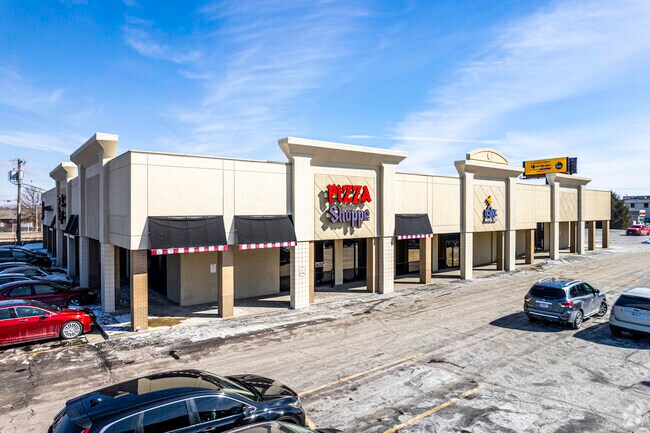
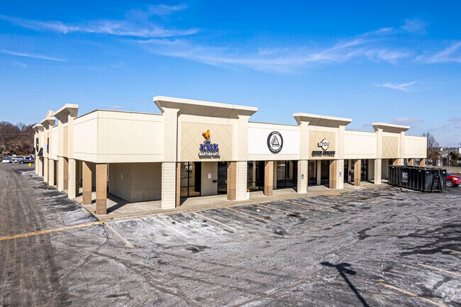
Property Record
7687 Nw Prairie View Rd, Kansas City, MO 64151
NEARBY LISTINGS FOR SALE OR LEASE
Property Detail
7687 Nw Prairie View Rd
19-40-18-200-004-003-000
BEG SW COR NW 1/4 TH N 665.11F TH E 101.75F TH NE 255F TO TPB TH NE 255F
Storebuilding
Platte
X
Missouri
29095C0106G
2.19 AC
2024
I-29 Corridor
2025
Kansas City
0302091007
Kansas City, MO-KS
19,600 SF
DEMOGRAPHICS near 7687 Nw Prairie View Rd
1 Mile
3 Mile
5 Mile
2024 Total Population
10,081
61,994
114,703
2029 Population
11,036
67,996
124,339
Pop Growth 2024-2029
+ 9.47%
+ 9.68%
+ 8.40%
Average Age
39
39
39
2024 Total Households
4,286
25,625
47,372
HH Growth 2024-2029
+ 9.92%
+ 9.85%
+ 8.44%
Median Household Inc
$75,216
$82,664
$75,411
Avg Household Size
2.30
2.30
2.30
2024 Avg HH Vehicles
2.00
2.00
2.00
Median Home Value
$240,232
$283,782
$269,666
Median Year Built
1986
1991
1989
Nearby Places
Map Layers
Map Styles
 Street
 Aerial
- Restaurants
- Banks
- Shops
- Fitness
- Groceries
PUBLIC TRANSPORTATION
AIRPORT
Kansas City International
DRIVE
WALK
Distance
Kansas City International
13 min
8.1 mi
SALE & LEASE HISTORY
LISTING DATE
SALE/LEASE

Feb 11, 2021
For Sale
Nearby Properties
Address
Land Use
TOTAL SIZE
Lot Size
Zoning
Address
Land Use
TOTAL SIZE
Lot Size
Zoning
1,837,323 SF
62.61 AC
Address
Land Use
TOTAL SIZE
Lot Size
Zoning
404,594 SF
40.87 AC
Address
Land Use
TOTAL SIZE
Lot Size
Zoning
738,848 SF
56.87 AC
Address
Land Use
TOTAL SIZE
Lot Size
Zoning
370,998 SF
34.29 AC
Address
Land Use
TOTAL SIZE
Lot Size
Zoning
374,876 SF
28.92 AC
Address
Land Use
TOTAL SIZE
Lot Size
Zoning
315,970 SF
30.23 AC
Address
Land Use
TOTAL SIZE
Lot Size
Zoning
627,957 SF
27.41 AC
Address
Land Use
TOTAL SIZE
Lot Size
Zoning
195,876 SF
14.62 AC
Address
Land Use
TOTAL SIZE
Lot Size
Zoning
675,632 SF
16.14 AC
Address
Land Use
TOTAL SIZE
Lot Size
Zoning
417,393 SF
22.13 AC
Address
Land Use
TOTAL SIZE
Lot Size
Zoning
437,830 SF
17.60 AC
Address
Land Use
TOTAL SIZE
Lot Size
Zoning
245,190 SF
25.40 AC
Address
Land Use
TOTAL SIZE
Lot Size
Zoning
349,586 SF
29.58 AC
Address
Land Use
TOTAL SIZE
Lot Size
Zoning
448,340 SF
6.42 AC
Address
Land Use
TOTAL SIZE
Lot Size
Zoning
231,778 SF
22.12 AC
Address
Land Use
TOTAL SIZE
Lot Size
Zoning
218,070 SF
12.79 AC
Address
Land Use
TOTAL SIZE
Lot Size
Zoning
183,994 SF
12.12 AC
Address
Land Use
TOTAL SIZE
Lot Size
Zoning
26,370 SF
14.55 AC
Address
Land Use
TOTAL SIZE
Lot Size
Zoning
280,535 SF
22 AC
Address
Land Use
TOTAL SIZE
Lot Size
Zoning
453,968 SF
4.66 AC
Address
Land Use
TOTAL SIZE
Lot Size
Zoning
251,983 SF
15.77 AC
Address
Land Use
TOTAL SIZE
Lot Size
Zoning
491,028 SF
16.35 AC
Address
Land Use
TOTAL SIZE
Lot Size
Zoning
104,706 SF
10.13 AC
Address
Land Use
TOTAL SIZE
Lot Size
Zoning
235,392 SF
21.32 AC
Address
Land Use
TOTAL SIZE
Lot Size
Zoning
255,096 SF
24.86 AC
Address
Land Use
TOTAL SIZE
Lot Size
Zoning
205,694 SF
20.02 AC
Address
Land Use
TOTAL SIZE
Lot Size
Zoning
239,208 SF
5.43 AC
EZ
Address
Land Use
TOTAL SIZE
Lot Size
Zoning
276,956 SF
1.68 AC
Address
Land Use
TOTAL SIZE
Lot Size
Zoning
90,000 SF
17.42 AC
Address
Land Use
TOTAL SIZE
Lot Size
Zoning
165,610 SF
18.07 AC
The World's #1 Commercial Real Estate Marketplace
Connect with us
© 2026 CoStar Group
The information above has been obtained from sources believed reliable. While we do not doubt its accuracy we have not verified it and make no guarantee, warranty or representation about it. It is your responsibility to independently confirm its accuracy and completeness. Any projections, opinions, assumptions, or estimates used are for example only and do not represent the current or future performance of the property. The value of this transaction to you depends on tax and other factors which should be evaluated by your tax, financial, and legal advisors. You and your advisors should conduct a careful, independent investigation of the property to determine to your satisfaction the suitability of the property for your needs.