Property Record
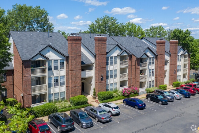
775 Gateway Dr Se, Leesburg, VA 20175


Property Detail
775 Gateway Dr Se
189-25-6327
LEESBURG GATEWAY PH.IIA PARCEL A3A 201507140046773, 201307020055760 200706290049461
Multifamilydwelling
Loudoun
LB:R22
Virginia
C and X Area of minimal flood hazard, usually depicted on FIRMs as above the 500-year flood level.
15.77 AC
2025
Outer Leesburg
2025
Washington, DC
610603
Washington-Arlington-Alexandria, DC-VA-MD-WV
248,513 SF
NEARBY LISTINGS FOR SALE OR LEASE
DEMOGRAPHICS near 775 Gateway Dr Se
1 mile
3 mile
5 mile
2025 Total Population
16,017
60,006
104,498
2030 Population
16,566
62,368
108,534
Pop Growth 2025-2030
+ 3.43%
+ 3.94%
+ 3.86%
Average Age
36
38
39
2025 Total Households
5,494
19,780
34,828
HH Growth 2025-2030
+ 3.17%
+ 3.94%
+ 3.93%
Median Household Inc
$109,641
$150,731
$173,488
Avg Household Size
2.80
3.00
2.90
2025 Avg HH Vehicles
2.00
2.00
2.00
Median Home Value
$569,533
$692,395
$728,989
Median Year Built
1990
1994
1999
Nearby Places
Map Layers
Map Styles
 Street
 Aerial
Layers
 Traffic
 Biking
Places
Listings with unknown addresses are not visible on the map
- Restaurants
- Banks
- Shops
- Fitness
- Groceries
PUBLIC TRANSPORTATION
AIRPORT
Washington Dulles International
Drive
Walk
Distance
Washington Dulles International
27 min
16.3 mi
Freight Ports
Port of Baltimore
Drive
Walk
Distance
Port of Baltimore
100 min
70.2 mi
Nearby Properties
Address
Land Use
TOTAL SIZE
Lot Size
Zoning
Address
Land Use
TOTAL SIZE
Lot Size
Zoning
793,474 SF
311.38 AC
PDIP
Address
Land Use
TOTAL SIZE
Lot Size
Zoning
413,297 SF
21.77 AC
LB:MC
Address
Land Use
TOTAL SIZE
Lot Size
Zoning
485,476 SF
54.14 AC
LB:B3
Address
Land Use
TOTAL SIZE
Lot Size
Zoning
89.99 AC
IP
Address
Land Use
TOTAL SIZE
Lot Size
Zoning
553,617 SF
592.60 AC
PDSA
Address
Land Use
TOTAL SIZE
Lot Size
Zoning
420,787 SF
LB:B4
Address
Land Use
TOTAL SIZE
Lot Size
Zoning
37.61 AC
IP
Address
Land Use
TOTAL SIZE
Lot Size
Zoning
331,227 SF
21.75 AC
LB:PRN
Address
Land Use
TOTAL SIZE
Lot Size
Zoning
279,428 SF
132.70 AC
LB:RE
Address
Land Use
TOTAL SIZE
Lot Size
Zoning
323,043 SF
27.90 AC
LB:B3
Address
Land Use
TOTAL SIZE
Lot Size
Zoning
228,886 SF
29.43 AC
LB:B3
Address
Land Use
TOTAL SIZE
Lot Size
Zoning
388,150 SF
PDIP
Address
Land Use
TOTAL SIZE
Lot Size
Zoning
261,445 SF
17.95 AC
LB:I1
Address
Land Use
TOTAL SIZE
Lot Size
Zoning
29.66 AC
OP
Address
Land Use
TOTAL SIZE
Lot Size
Zoning
242,603 SF
67.48 AC
LB:RE
Address
Land Use
TOTAL SIZE
Lot Size
Zoning
245,886 SF
52.32 AC
LB:RE
Address
Land Use
TOTAL SIZE
Lot Size
Zoning
158,560 SF
2.44 AC
LB:GC
Address
Land Use
TOTAL SIZE
Lot Size
Zoning
294,934 SF
7.11 AC
PDIP
Address
Land Use
TOTAL SIZE
Lot Size
Zoning
258,867 SF
12.57 AC
LB:R22
Address
Land Use
TOTAL SIZE
Lot Size
Zoning
131,283 SF
27.84 AC
LB:B3
Address
Land Use
TOTAL SIZE
Lot Size
Zoning
148,448 SF
9.71 AC
LB:PEC
Address
Land Use
TOTAL SIZE
Lot Size
Zoning
190,454 SF
31.50 AC
LB:R4
Address
Land Use
TOTAL SIZE
Lot Size
Zoning
83,169 SF
138.05 AC
LB:R1
Address
Land Use
TOTAL SIZE
Lot Size
Zoning
196,665 SF
18.96 AC
LB:PRN
Address
Land Use
TOTAL SIZE
Lot Size
Zoning
72,408 SF
197.99 AC
AR1
Address
Land Use
TOTAL SIZE
Lot Size
Zoning
156,958 SF
17.63 AC
LB:PRC
Address
Land Use
TOTAL SIZE
Lot Size
Zoning
31.69 AC
GI
Address
Land Use
TOTAL SIZE
Lot Size
Zoning
18.85 AC
PDH4
The World's #1 Commercial Real Estate Marketplace
Connect with us
© 2026 CoStar Group
The information above has been obtained from sources believed reliable. While we do not doubt its accuracy we have not verified it and make no guarantee, warranty or representation about it. It is your responsibility to independently confirm its accuracy and completeness. Any projections, opinions, assumptions, or estimates used are for example only and do not represent the current or future performance of the property. The value of this transaction to you depends on tax and other factors which should be evaluated by your tax, financial, and legal advisors. You and your advisors should conduct a careful, independent investigation of the property to determine to your satisfaction the suitability of the property for your needs.