Property Record
7770 Farr St, Daniel Island, SC 29492
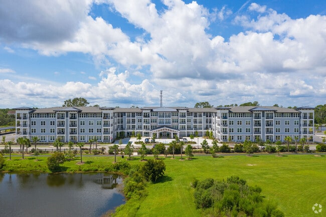

Property Detail
7770 Farr St
275-00-00-286
PARCEL S, TRACT 2
Commercialnec
Berkeley
CHARLESTON
South Carolina
AE The base floodplain where base flood elevations are provided. AE Zones are now used on new format FIRMs instead of A1-A30 Zones.
6.66 AC
2025
Daniel Island
2025
Charleston/N Charleston
020407
Charleston-North Charleston, SC
267,280 SF
NEARBY LISTINGS FOR SALE OR LEASE
-
-
View all Daniel Island listings for sale on LoopNet.com
DEMOGRAPHICS near 7770 Farr St
1 mile
3 mile
5 mile
2025 Total Population
7,412
23,732
104,514
2030 Population
8,374
26,473
111,494
Pop Growth 2025-2030
+ 12.98%
+ 11.55%
+ 6.68%
Average Age
41
41
39
2025 Total Households
3,156
10,136
44,704
HH Growth 2025-2030
+ 13.66%
+ 12.02%
+ 7.06%
Median Household Inc
$125,967
$110,341
$87,400
Avg Household Size
2.30
2.30
2.20
2025 Avg HH Vehicles
2.00
2.00
2.00
Median Home Value
$894,584
$959,296
$715,791
Median Year Built
2007
2007
1988
Nearby Places
Map Layers
Map Styles
 Street
 Aerial
Layers
 Traffic
 Biking
Places
Listings with unknown addresses are not visible on the map
- Restaurants
- Banks
- Shops
- Fitness
- Groceries
PUBLIC TRANSPORTATION
COMMUTER RAIL
Charleston Amtrak Station (Palmetto - Amtrak, Silver Meteor - Amtrak)
Drive
Walk
Distance
Charleston Amtrak Station (Palmetto - Amtrak, Silver Meteor - Amtrak)
16 min
9.0 mi
AIRPORT
Charleston AFB/International
Drive
Walk
Distance
Charleston AFB/International
24 min
14.5 mi
Freight Ports
Veterans Terminal
Drive
Walk
Distance
Veterans Terminal
21 min
13.4 mi
Nearby Properties
Address
Land Use
TOTAL SIZE
Lot Size
Zoning
Address
Land Use
TOTAL SIZE
Lot Size
Zoning
27,900 SF
102.67 AC
Address
Land Use
TOTAL SIZE
Lot Size
Zoning
22,620 SF
12.23 AC
Address
Land Use
TOTAL SIZE
Lot Size
Zoning
Address
Land Use
TOTAL SIZE
Lot Size
Zoning
127,156 SF
12.49 AC
Address
Land Use
TOTAL SIZE
Lot Size
Zoning
56,268 SF
29.66 AC
BERKELEY C
Address
Land Use
TOTAL SIZE
Lot Size
Zoning
29,118 SF
7.83 AC
CHARLESTON
Address
Land Use
TOTAL SIZE
Lot Size
Zoning
15,957 SF
3.80 AC
Address
Land Use
TOTAL SIZE
Lot Size
Zoning
3,462 SF
24.85 AC
Address
Land Use
TOTAL SIZE
Lot Size
Zoning
372,400 SF
5.59 AC
CHARLESTON
Address
Land Use
TOTAL SIZE
Lot Size
Zoning
112,440 SF
16.15 AC
CHARLESTON
Address
Land Use
TOTAL SIZE
Lot Size
Zoning
11,681 SF
1.16 AC
Address
Land Use
TOTAL SIZE
Lot Size
Zoning
21,260 SF
1.59 AC
Address
Land Use
TOTAL SIZE
Lot Size
Zoning
19,994 SF
2.04 AC
Address
Land Use
TOTAL SIZE
Lot Size
Zoning
62,366 SF
12.65 AC
CHARLESTON
Address
Land Use
TOTAL SIZE
Lot Size
Zoning
148,760 SF
6.91 AC
CHARLESTON
Address
Land Use
TOTAL SIZE
Lot Size
Zoning
14,402 SF
9.83 AC
CHARLESTON
Address
Land Use
TOTAL SIZE
Lot Size
Zoning
2.10 AC
Address
Land Use
TOTAL SIZE
Lot Size
Zoning
181,318 SF
4.87 AC
CHARLESTON
Address
Land Use
TOTAL SIZE
Lot Size
Zoning
17.99 AC
Address
Land Use
TOTAL SIZE
Lot Size
Zoning
Address
Land Use
TOTAL SIZE
Lot Size
Zoning
5,330 SF
1.93 AC
Address
Land Use
TOTAL SIZE
Lot Size
Zoning
Address
Land Use
TOTAL SIZE
Lot Size
Zoning
203,403 SF
9.77 AC
CHARLESTON
Address
Land Use
TOTAL SIZE
Lot Size
Zoning
6,848 SF
43.53 AC
CHARLESTON
Address
Land Use
TOTAL SIZE
Lot Size
Zoning
96,576 SF
11.20 AC
CHARLESTON
Address
Land Use
TOTAL SIZE
Lot Size
Zoning
Address
Land Use
TOTAL SIZE
Lot Size
Zoning
224,766 SF
20.33 AC
CHARLESTON
Address
Land Use
TOTAL SIZE
Lot Size
Zoning
870 SF
14.87 AC
BERKELEY C
Address
Land Use
TOTAL SIZE
Lot Size
Zoning
16.96 AC
The World's #1 Commercial Real Estate Marketplace
Connect with us
© 2026 CoStar Group
The information above has been obtained from sources believed reliable. While we do not doubt its accuracy we have not verified it and make no guarantee, warranty or representation about it. It is your responsibility to independently confirm its accuracy and completeness. Any projections, opinions, assumptions, or estimates used are for example only and do not represent the current or future performance of the property. The value of this transaction to you depends on tax and other factors which should be evaluated by your tax, financial, and legal advisors. You and your advisors should conduct a careful, independent investigation of the property to determine to your satisfaction the suitability of the property for your needs.