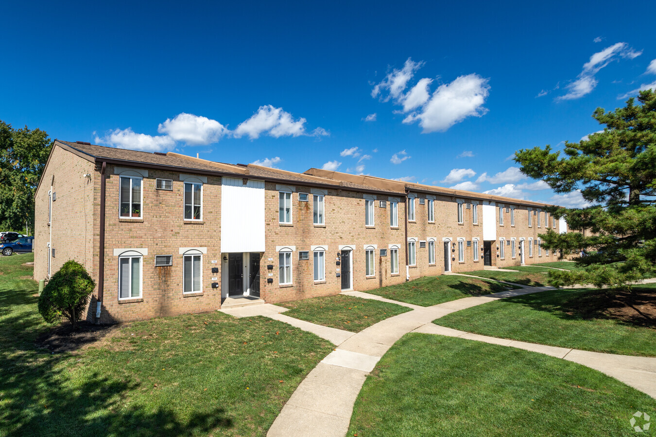
Property Record
7800 Lindbergh Blvd, Philadelphia, PA 19153

NEARBY LISTINGS FOR SALE OR LEASE
Property Detail
7800 Lindbergh Blvd
Philadelphia-Camden-Wilmington, PA-NJ-DE-MD
Penrose Park Apartments
881141900
SEC 80TH ST
Apartment
Philadelphia
AE
Pennsylvania
4207570188H
3
2024
11 AC
2025
Eastwick-Southwest Philadelphia
005600
Philadelphia
246,303 SF
DEMOGRAPHICS near 7800 Lindbergh Blvd
1 Mile
3 Mile
5 Mile
2024 Total Population
15,163
139,413
569,617
2029 Population
14,686
136,391
556,980
Pop Growth 2024-2029
(3.15%)
(2.17%)
(2.22%)
Average Age
40
38
38
2024 Total Households
6,128
52,869
225,400
HH Growth 2024-2029
(3.25%)
(2.27%)
(2.42%)
Median Household Inc
$54,513
$48,667
$55,400
Avg Household Size
2.40
2.60
2.40
2024 Avg HH Vehicles
1.00
1.00
1.00
Median Home Value
$154,402
$137,999
$195,926
Median Year Built
1963
1951
1948
Nearby Places
- Restaurants
- Banks
- Shops
- Fitness
- Groceries
PUBLIC TRANSPORTATION
TRANSIT/SUBWAY
Island Avenue And Lindbergh Avenue (Route 36 - Southeastern Pennsylvania Transportation Authority Rapid Transit (SEPTA Subway & Trolley))
DRIVE
WALK
Distance
Island Avenue And Lindbergh Avenue (Route 36 - Southeastern Pennsylvania Transportation Authority Rapid Transit (SEPTA Subway & Trolley))
4 min
8 min
0.4 mi
Penrose Plaza Shopping Center (Route 36 - Southeastern Pennsylvania Transportation Authority Rapid Transit (SEPTA Subway & Trolley))
DRIVE
WALK
Distance
Penrose Plaza Shopping Center (Route 36 - Southeastern Pennsylvania Transportation Authority Rapid Transit (SEPTA Subway & Trolley))
2 min
8 min
0.5 mi
Island Avenue And 76Th Street (Route 36 - Southeastern Pennsylvania Transportation Authority Rapid Transit (SEPTA Subway & Trolley))
DRIVE
WALK
Distance
Island Avenue And 76Th Street (Route 36 - Southeastern Pennsylvania Transportation Authority Rapid Transit (SEPTA Subway & Trolley))
4 min
12 min
0.6 mi
Island Avenue And Suffolk Avenue (Route 36 - Southeastern Pennsylvania Transportation Authority Rapid Transit (SEPTA Subway & Trolley))
DRIVE
WALK
Distance
Island Avenue And Suffolk Avenue (Route 36 - Southeastern Pennsylvania Transportation Authority Rapid Transit (SEPTA Subway & Trolley))
2 min
12 min
0.6 mi
Island Avenue And Tanager Street (Route 36 - Southeastern Pennsylvania Transportation Authority Rapid Transit (SEPTA Subway & Trolley))
DRIVE
WALK
Distance
Island Avenue And Tanager Street (Route 36 - Southeastern Pennsylvania Transportation Authority Rapid Transit (SEPTA Subway & Trolley))
3 min
13 min
0.7 mi
COMMUTER RAIL
Eastwick (R1 - Southeastern Pennsylvania Transportation Authority Regional Rail (SEPTA Regional Rail))
DRIVE
WALK
Distance
Eastwick (R1 - Southeastern Pennsylvania Transportation Authority Regional Rail (SEPTA Regional Rail))
4 min
20 min
1.1 mi
Darby (R2 - Southeastern Pennsylvania Transportation Authority Regional Rail (SEPTA Regional Rail))
DRIVE
WALK
Distance
Darby (R2 - Southeastern Pennsylvania Transportation Authority Regional Rail (SEPTA Regional Rail))
7 min
2.3 mi
AIRPORT
Philadelphia International
DRIVE
WALK
Distance
Philadelphia International
10 min
4.0 mi
Freight Ports
South Jersey Port
DRIVE
WALK
Distance
South Jersey Port
23 min
11.9 mi
Nearby Properties
Address
Land Use
TOTAL SIZE
Lot Size
Zoning
Address
Land Use
TOTAL SIZE
Lot Size
Zoning
678,227 SF
850.40 AC
SPAIR
Address
Land Use
TOTAL SIZE
Lot Size
Zoning
762,100 SF
Address
Land Use
TOTAL SIZE
Lot Size
Zoning
685,000 SF
47.69 AC
CMX3
Address
Land Use
TOTAL SIZE
Lot Size
Zoning
387,472 SF
4.61 AC
I3
Address
Land Use
TOTAL SIZE
Lot Size
Zoning
910,000 SF
70 AC
I2
Address
Land Use
TOTAL SIZE
Lot Size
Zoning
10,080 SF
3.10 AC
I3
Address
Land Use
TOTAL SIZE
Lot Size
Zoning
488,254 SF
31.56 AC
I2
Address
Land Use
TOTAL SIZE
Lot Size
Zoning
995,943 SF
212.65 AC
Address
Land Use
TOTAL SIZE
Lot Size
Zoning
89,456 SF
27.06 AC
Address
Land Use
TOTAL SIZE
Lot Size
Zoning
97,810 SF
40 AC
I3
Address
Land Use
TOTAL SIZE
Lot Size
Zoning
335,340 SF
23.83 AC
I2
Address
Land Use
TOTAL SIZE
Lot Size
Zoning
164,182 SF
Address
Land Use
TOTAL SIZE
Lot Size
Zoning
25,680 SF
31.64 AC
Address
Land Use
TOTAL SIZE
Lot Size
Zoning
323,248 SF
2.90 AC
SPAIR
Address
Land Use
TOTAL SIZE
Lot Size
Zoning
975.62 AC
Address
Land Use
TOTAL SIZE
Lot Size
Zoning
200,000 SF
22 AC
RMX3
Address
Land Use
TOTAL SIZE
Lot Size
Zoning
226,764 SF
5.72 AC
CMX3
Address
Land Use
TOTAL SIZE
Lot Size
Zoning
140,010 SF
28.50 AC
ICMX
Address
Land Use
TOTAL SIZE
Lot Size
Zoning
63.81 AC
I2
Address
Land Use
TOTAL SIZE
Lot Size
Zoning
307,425 SF
18.88 AC
I3
Address
Land Use
TOTAL SIZE
Lot Size
Zoning
63.53 AC
CMX3
Address
Land Use
TOTAL SIZE
Lot Size
Zoning
120,349 SF
37.24 AC
I3
Address
Land Use
TOTAL SIZE
Lot Size
Zoning
33,200 SF
19.55 AC
I2
Address
Land Use
TOTAL SIZE
Lot Size
Zoning
3,600 SF
6.61 AC
SPPOA
Address
Land Use
TOTAL SIZE
Lot Size
Zoning
96,500 SF
6.11 AC
CMX3
Address
Land Use
TOTAL SIZE
Lot Size
Zoning
363,215 SF
7.27 AC
RM1
Address
Land Use
TOTAL SIZE
Lot Size
Zoning
16,990 SF
221.09 AC
SPPOA
Address
Land Use
TOTAL SIZE
Lot Size
Zoning
86.10 AC
Address
Land Use
TOTAL SIZE
Lot Size
Zoning
40,572 SF
6.52 AC
Address
Land Use
TOTAL SIZE
Lot Size
Zoning
192,000 SF
6.40 AC
CMX3
The World's #1 Commercial Real Estate Marketplace
Connect with us
© 2025 CoStar Group
The information above has been obtained from sources believed reliable. While we do not doubt its accuracy we have not verified it and make no guarantee, warranty or representation about it. It is your responsibility to independently confirm its accuracy and completeness. Any projections, opinions, assumptions, or estimates used are for example only and do not represent the current or future performance of the property. The value of this transaction to you depends on tax and other factors which should be evaluated by your tax, financial, and legal advisors. You and your advisors should conduct a careful, independent investigation of the property to determine to your satisfaction the suitability of the property for your needs.