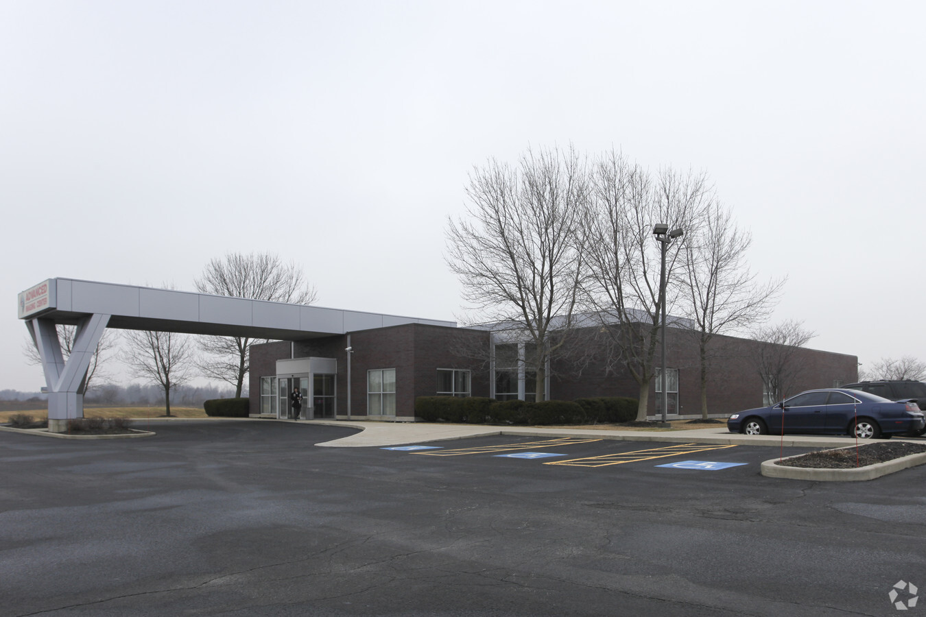
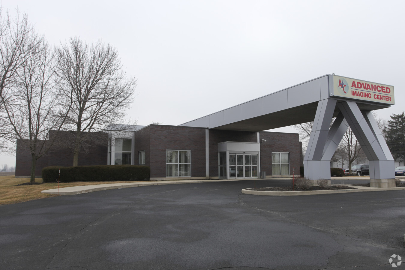
Property Record
7860 Burr St, Schererville, IN 46375
NEARBY LISTINGS FOR SALE OR LEASE
Property Detail
7860 Burr St
Chicago-Naperville-Elgin, IL-IN-WI
Diagnostic Plaza Addition
45-11-24-126-002.000-036
DIAGNOSTIC PLAZA ADDITION LOT 1
Medicalbuilding
Lake
X
Indiana
18089C0232E
1
2023
3.29 AC
2024
Indiana
042602
Chicago
19,194 SF
DEMOGRAPHICS near 7860 Burr St
1 Mile
3 Mile
5 Mile
2024 Total Population
8,182
44,335
124,214
2029 Population
8,120
44,177
124,222
Pop Growth 2024-2029
(0.76%)
(0.36%)
+ 0.01%
Average Age
39
41
42
2024 Total Households
3,347
17,370
49,626
HH Growth 2024-2029
(0.84%)
(0.37%)
(0.02%)
Median Household Inc
$71,055
$79,555
$73,210
Avg Household Size
2.40
2.50
2.40
2024 Avg HH Vehicles
2.00
2.00
2.00
Median Home Value
$253,336
$242,340
$230,848
Median Year Built
1987
1986
1978
Nearby Places
- Restaurants
- Banks
- Shops
- Fitness
- Groceries
PUBLIC TRANSPORTATION
COMMUTER RAIL
Dyer Amtrak (Cardinal - Amtrak)
DRIVE
WALK
Distance
Dyer Amtrak (Cardinal - Amtrak)
14 min
7.9 mi
AIRPORT
Chicago Midway International
DRIVE
WALK
Distance
Chicago Midway International
57 min
36.2 mi
Freight Ports
Port Milwaukee
DRIVE
WALK
Distance
Port Milwaukee
160 min
122.4 mi
Nearby Properties
Address
Land Use
TOTAL SIZE
Lot Size
Zoning
Address
Land Use
TOTAL SIZE
Lot Size
Zoning
206,854 SF
8.38 AC
Address
Land Use
TOTAL SIZE
Lot Size
Zoning
536,896 SF
20.08 AC
Address
Land Use
TOTAL SIZE
Lot Size
Zoning
365,748 SF
17.44 AC
R33
Address
Land Use
TOTAL SIZE
Lot Size
Zoning
289,840 SF
15.31 AC
Address
Land Use
TOTAL SIZE
Lot Size
Zoning
100,659 SF
3.89 AC
Address
Land Use
TOTAL SIZE
Lot Size
Zoning
236,904 SF
11.30 AC
R33
Address
Land Use
TOTAL SIZE
Lot Size
Zoning
116,352 SF
9 AC
Address
Land Use
TOTAL SIZE
Lot Size
Zoning
116,352 SF
8.08 AC
Address
Land Use
TOTAL SIZE
Lot Size
Zoning
132,147 SF
44.38 AC
R33
Address
Land Use
TOTAL SIZE
Lot Size
Zoning
190,352 SF
12.36 AC
Address
Land Use
TOTAL SIZE
Lot Size
Zoning
304,429 SF
84.07 AC
Address
Land Use
TOTAL SIZE
Lot Size
Zoning
87,264 SF
7.74 AC
Address
Land Use
TOTAL SIZE
Lot Size
Zoning
45,397 SF
14.48 AC
Address
Land Use
TOTAL SIZE
Lot Size
Zoning
47,881 SF
23.63 AC
R33
Address
Land Use
TOTAL SIZE
Lot Size
Zoning
125,172 SF
5.57 AC
R33
Address
Land Use
TOTAL SIZE
Lot Size
Zoning
66,464 SF
43.30 AC
Address
Land Use
TOTAL SIZE
Lot Size
Zoning
52,896 SF
4.06 AC
R33
Address
Land Use
TOTAL SIZE
Lot Size
Zoning
41,015 SF
4.87 AC
Address
Land Use
TOTAL SIZE
Lot Size
Zoning
26,738 SF
4.67 AC
Address
Land Use
TOTAL SIZE
Lot Size
Zoning
42,090 SF
4.04 AC
Address
Land Use
TOTAL SIZE
Lot Size
Zoning
52,178 SF
5.11 AC
Address
Land Use
TOTAL SIZE
Lot Size
Zoning
49,184 SF
28.68 AC
Address
Land Use
TOTAL SIZE
Lot Size
Zoning
81,568 SF
9.31 AC
Address
Land Use
TOTAL SIZE
Lot Size
Zoning
29,654 SF
7.81 AC
R33
Address
Land Use
TOTAL SIZE
Lot Size
Zoning
33,876 SF
15.14 AC
Address
Land Use
TOTAL SIZE
Lot Size
Zoning
112,309 SF
7.24 AC
Address
Land Use
TOTAL SIZE
Lot Size
Zoning
105,520 SF
17.52 AC
Address
Land Use
TOTAL SIZE
Lot Size
Zoning
97,674 SF
29.16 AC
Address
Land Use
TOTAL SIZE
Lot Size
Zoning
38,464 SF
3.10 AC
R33
The World's #1 Commercial Real Estate Marketplace
Connect with us
© 2025 CoStar Group
The information above has been obtained from sources believed reliable. While we do not doubt its accuracy we have not verified it and make no guarantee, warranty or representation about it. It is your responsibility to independently confirm its accuracy and completeness. Any projections, opinions, assumptions, or estimates used are for example only and do not represent the current or future performance of the property. The value of this transaction to you depends on tax and other factors which should be evaluated by your tax, financial, and legal advisors. You and your advisors should conduct a careful, independent investigation of the property to determine to your satisfaction the suitability of the property for your needs.