Property Record
7814 N Ranch Rd 620 Rd, Austin, TX 78726


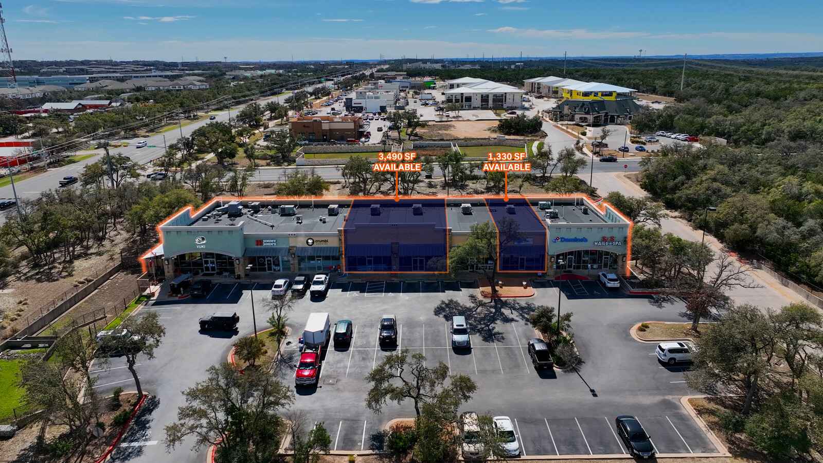
Current Lease Availabilities
NEARBY LISTINGS FOR SALE OR LEASE
Property Detail
7814 N Ranch Rd 620 Rd
Austin-Round Rock, TX
Grandview Hills Sec 10
497840
LOT 1 BLK A GRANDVIEW HILLS SEC 10
Regionalshoppingcenterormallwithanchorstore
Travis
X
Texas
48453C0240K
1
2023
2.78 AC
2023
Far Northwest
034600
Austin
15,400 SF
DEMOGRAPHICS near 7814 N Ranch Rd 620 Rd
1 Mile
3 Mile
5 Mile
2024 Total Population
4,557
26,542
112,487
2029 Population
4,877
28,385
128,110
Pop Growth 2024-2029
+ 7.02%
+ 6.94%
+ 13.89%
Average Age
35
38
39
2024 Total Households
2,068
10,831
44,533
HH Growth 2024-2029
+ 7.64%
+ 7.69%
+ 15.26%
Median Household Inc
$100,500
$118,095
$117,599
Avg Household Size
2.10
2.40
2.50
2024 Avg HH Vehicles
2.00
2.00
2.00
Median Home Value
$709,239
$716,344
$580,159
Median Year Built
2005
1999
1996
Nearby Places
- Restaurants
- Banks
- Shops
- Fitness
- Groceries
PUBLIC TRANSPORTATION
COMMUTER RAIL
Lakeline Station (Capital MetroRail - Capital Metropolitan Transportation Authority Rail (MetroRail))
DRIVE
WALK
Distance
Lakeline Station (Capital MetroRail - Capital Metropolitan Transportation Authority Rail (MetroRail))
15 min
7.4 mi
AIRPORT
Austin-Bergstrom International
DRIVE
WALK
Distance
Austin-Bergstrom International
39 min
28.8 mi
Nearby Properties
Address
Land Use
TOTAL SIZE
Lot Size
Zoning
Address
Land Use
TOTAL SIZE
Lot Size
Zoning
752,839 SF
116.77 AC
Address
Land Use
TOTAL SIZE
Lot Size
Zoning
638,467 SF
47.71 AC
Address
Land Use
TOTAL SIZE
Lot Size
Zoning
494,958 SF
39.50 AC
Address
Land Use
TOTAL SIZE
Lot Size
Zoning
525,852 SF
30.92 AC
Address
Land Use
TOTAL SIZE
Lot Size
Zoning
576,996 SF
38.77 AC
Address
Land Use
TOTAL SIZE
Lot Size
Zoning
610,326 SF
43.30 AC
Address
Land Use
TOTAL SIZE
Lot Size
Zoning
1,396,406 SF
107.21 AC
Address
Land Use
TOTAL SIZE
Lot Size
Zoning
342,992 SF
17.53 AC
Address
Land Use
TOTAL SIZE
Lot Size
Zoning
325,840 SF
26.25 AC
Address
Land Use
TOTAL SIZE
Lot Size
Zoning
388,673 SF
30.98 AC
Address
Land Use
TOTAL SIZE
Lot Size
Zoning
411,288 SF
27.68 AC
Address
Land Use
TOTAL SIZE
Lot Size
Zoning
323,718 SF
17.45 AC
Address
Land Use
TOTAL SIZE
Lot Size
Zoning
349,200 SF
28.91 AC
Address
Land Use
TOTAL SIZE
Lot Size
Zoning
235,808 SF
59.36 AC
Address
Land Use
TOTAL SIZE
Lot Size
Zoning
276,728 SF
16.25 AC
Address
Land Use
TOTAL SIZE
Lot Size
Zoning
285,768 SF
23.77 AC
Address
Land Use
TOTAL SIZE
Lot Size
Zoning
270,504 SF
21.75 AC
Address
Land Use
TOTAL SIZE
Lot Size
Zoning
172,975 SF
33.88 AC
Address
Land Use
TOTAL SIZE
Lot Size
Zoning
262,480 SF
27.52 AC
Address
Land Use
TOTAL SIZE
Lot Size
Zoning
179,796 SF
5.08 AC
Address
Land Use
TOTAL SIZE
Lot Size
Zoning
190,865 SF
7.30 AC
Address
Land Use
TOTAL SIZE
Lot Size
Zoning
222,200 SF
39.03 AC
Address
Land Use
TOTAL SIZE
Lot Size
Zoning
196,610 SF
383.96 AC
Address
Land Use
TOTAL SIZE
Lot Size
Zoning
208,395 SF
32.42 AC
Address
Land Use
TOTAL SIZE
Lot Size
Zoning
273,841 SF
14.69 AC
Address
Land Use
TOTAL SIZE
Lot Size
Zoning
116,463 SF
15.27 AC
Address
Land Use
TOTAL SIZE
Lot Size
Zoning
18.22 AC
Address
Land Use
TOTAL SIZE
Lot Size
Zoning
52,022 SF
32 AC
Address
Land Use
TOTAL SIZE
Lot Size
Zoning
109,724 SF
8.51 AC
Address
Land Use
TOTAL SIZE
Lot Size
Zoning
57,408 SF
5.82 AC
The World's #1 Commercial Real Estate Marketplace
Connect with us
© 2025 CoStar Group
The information above has been obtained from sources believed reliable. While we do not doubt its accuracy we have not verified it and make no guarantee, warranty or representation about it. It is your responsibility to independently confirm its accuracy and completeness. Any projections, opinions, assumptions, or estimates used are for example only and do not represent the current or future performance of the property. The value of this transaction to you depends on tax and other factors which should be evaluated by your tax, financial, and legal advisors. You and your advisors should conduct a careful, independent investigation of the property to determine to your satisfaction the suitability of the property for your needs.