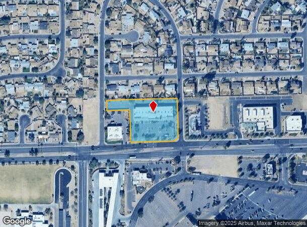
Property Record
7910 W Thomas Rd, Phoenix, AZ 85033
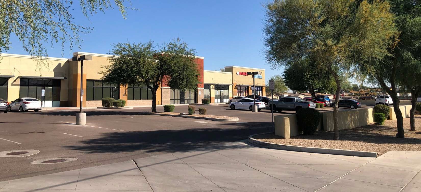
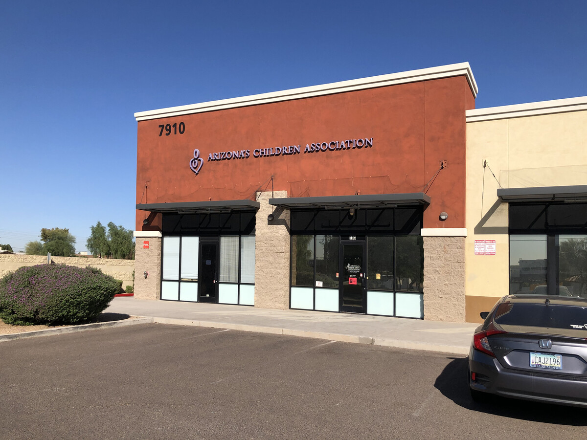
Current Lease Availabilities
NEARBY LISTINGS FOR SALE OR LEASE
Property Detail
7910 W Thomas Rd
102-22-006X
TH PT SE4 DAF BEG SE COR LOT 358 LAURELWOOD 4 MCR 194/49 TH W ALG S LN LOTS 353 THRU 358 459.08F TO SW COR LOT 353 SD SUB TH S 1D 28M W ALG E R/W LN 79TH LN PER MCR 194/49 67.20F TH E 150.81F TH S 208F TO PT ON N R/W LN THOMAS RD P/D 15755-540 TH E A
Storebuilding
Maricopa
X
Arizona
04013C2180L
358
2024
2.18 AC
2025
West Phoenix/Maryvale
109702
Phoenix
18,455 SF
Phoenix-Mesa-Scottsdale, AZ
DEMOGRAPHICS near 7910 W Thomas Rd
1 Mile
3 Mile
5 Mile
2024 Total Population
22,940
167,983
390,664
2029 Population
24,624
180,981
422,106
Pop Growth 2024-2029
+ 7.34%
+ 7.74%
+ 8.05%
Average Age
32
32
33
2024 Total Households
6,208
45,908
111,942
HH Growth 2024-2029
+ 7.43%
+ 7.85%
+ 8.27%
Median Household Inc
$62,054
$56,754
$59,302
Avg Household Size
3.60
3.50
3.30
2024 Avg HH Vehicles
2.00
2.00
2.00
Median Home Value
$222,081
$237,015
$258,698
Median Year Built
1979
1981
1986
Nearby Places
- Restaurants
- Banks
- Shops
- Fitness
- Groceries
PUBLIC TRANSPORTATION
AIRPORT
Phoenix Sky Harbor International
DRIVE
WALK
Distance
Phoenix Sky Harbor International
24 min
16.4 mi
Freight Ports
Port of San Diego
DRIVE
WALK
Distance
Port of San Diego
386 min
347.0 mi
Nearby Properties
Address
Land Use
TOTAL SIZE
Lot Size
Zoning
Address
Land Use
TOTAL SIZE
Lot Size
Zoning
896,916 SF
25.91 AC
C-C
Address
Land Use
TOTAL SIZE
Lot Size
Zoning
1,539,348 SF
143.97 AC
A-1
Address
Land Use
TOTAL SIZE
Lot Size
Zoning
1,100,500 SF
57.61 AC
PUD
Address
Land Use
TOTAL SIZE
Lot Size
Zoning
348,753 SF
19.36 AC
R-6
Address
Land Use
TOTAL SIZE
Lot Size
Zoning
750,037 SF
49.40 AC
I1
Address
Land Use
TOTAL SIZE
Lot Size
Zoning
569,517 SF
35.28 AC
PUD
Address
Land Use
TOTAL SIZE
Lot Size
Zoning
587,843 SF
20.49 AC
PAD
Address
Land Use
TOTAL SIZE
Lot Size
Zoning
659,834 SF
42.04 AC
R-6
Address
Land Use
TOTAL SIZE
Lot Size
Zoning
258,097 SF
32.53 AC
AG
Address
Land Use
TOTAL SIZE
Lot Size
Zoning
351,903 SF
29.12 AC
A1
Address
Land Use
TOTAL SIZE
Lot Size
Zoning
466,868 SF
45.99 AC
I-1
Address
Land Use
TOTAL SIZE
Lot Size
Zoning
436,817 SF
23.21 AC
I-P
Address
Land Use
TOTAL SIZE
Lot Size
Zoning
580,382 SF
31.77 AC
PAD
Address
Land Use
TOTAL SIZE
Lot Size
Zoning
316,386 SF
45.04 AC
R16
Address
Land Use
TOTAL SIZE
Lot Size
Zoning
660,980 SF
40.15 AC
Address
Land Use
TOTAL SIZE
Lot Size
Zoning
660,807 SF
31.44 AC
PAD-14
Address
Land Use
TOTAL SIZE
Lot Size
Zoning
498,064 SF
12.92 AC
C-N
Address
Land Use
TOTAL SIZE
Lot Size
Zoning
370,522 SF
9.45 AC
Address
Land Use
TOTAL SIZE
Lot Size
Zoning
587,158 SF
36.22 AC
I-P
Address
Land Use
TOTAL SIZE
Lot Size
Zoning
401,437 SF
25.82 AC
Address
Land Use
TOTAL SIZE
Lot Size
Zoning
543,745 SF
31.09 AC
I-1
Address
Land Use
TOTAL SIZE
Lot Size
Zoning
310,134 SF
64.97 AC
I-1
Address
Land Use
TOTAL SIZE
Lot Size
Zoning
313,110 SF
18.08 AC
I-1
Address
Land Use
TOTAL SIZE
Lot Size
Zoning
476,073 SF
27.62 AC
I-1
Address
Land Use
TOTAL SIZE
Lot Size
Zoning
92,600 SF
20 AC
C-C
Address
Land Use
TOTAL SIZE
Lot Size
Zoning
324,800 SF
18.69 AC
I-1
Address
Land Use
TOTAL SIZE
Lot Size
Zoning
370,119 SF
18.79 AC
M-H
Address
Land Use
TOTAL SIZE
Lot Size
Zoning
108,128 SF
18.55 AC
R-43AG
Address
Land Use
TOTAL SIZE
Lot Size
Zoning
106,215 SF
27.96 AC
PF
Address
Land Use
TOTAL SIZE
Lot Size
Zoning
146,607 SF
0.76 AC
C-C
The World's #1 Commercial Real Estate Marketplace
Connect with us
© 2025 CoStar Group
The information above has been obtained from sources believed reliable. While we do not doubt its accuracy we have not verified it and make no guarantee, warranty or representation about it. It is your responsibility to independently confirm its accuracy and completeness. Any projections, opinions, assumptions, or estimates used are for example only and do not represent the current or future performance of the property. The value of this transaction to you depends on tax and other factors which should be evaluated by your tax, financial, and legal advisors. You and your advisors should conduct a careful, independent investigation of the property to determine to your satisfaction the suitability of the property for your needs.