Property Record
794 Pine St, Muskegon, MI 49442
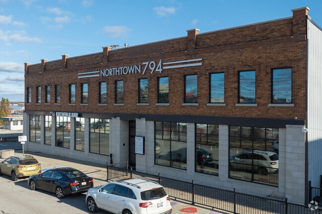


This Property Is For Sale
Current Lease Availabilities
NEARBY LISTINGS FOR SALE OR LEASE
Property Detail
794 Pine St
Muskegon, MI
City Of Muskegon Revised Plat (Of 1903)
24-205-177-0005-00
CITY OF MUSKEGON REVISED PLAT OF 1903 THAT PART OF LOT 4 BLK 177 LYING WLY OF A LN WHICH BEGINS AT A POINT ON SLY LN CLAY AVE
Commercialnec
Muskegon
X
Michigan
26121C0276E
4-6
2024
0.51 AC
2025
Muskegon Heights
004200
West Michigan
21,000 SF
DEMOGRAPHICS near 794 Pine St
1 Mile
3 Mile
5 Mile
2024 Total Population
8,912
56,990
98,087
2029 Population
9,130
57,683
98,890
Pop Growth 2024-2029
+ 2.45%
+ 1.22%
+ 0.82%
Average Age
38
39
40
2024 Total Households
3,688
21,779
38,732
HH Growth 2024-2029
+ 2.52%
+ 1.20%
+ 0.80%
Median Household Inc
$24,717
$40,371
$49,312
Avg Household Size
2.10
2.30
2.30
2024 Avg HH Vehicles
1.00
1.00
2.00
Median Home Value
$88,833
$101,429
$138,863
Median Year Built
1948
1952
1959
Nearby Places
Map Layers
Map Styles
 Street
 Aerial
- Restaurants
- Banks
- Shops
- Fitness
- Groceries
Nearby Properties
Address
Land Use
TOTAL SIZE
Lot Size
Zoning
Address
Land Use
TOTAL SIZE
Lot Size
Zoning
490,693 SF
22.70 AC
Address
Land Use
TOTAL SIZE
Lot Size
Zoning
82,643 SF
5.20 AC
MC
Address
Land Use
TOTAL SIZE
Lot Size
Zoning
84,452 SF
6.82 AC
PUD
Address
Land Use
TOTAL SIZE
Lot Size
Zoning
446,688 SF
29.50 AC
RM-2
Address
Land Use
TOTAL SIZE
Lot Size
Zoning
892,516 SF
57.88 AC
I
Address
Land Use
TOTAL SIZE
Lot Size
Zoning
79,321 SF
4.28 AC
B-3
Address
Land Use
TOTAL SIZE
Lot Size
Zoning
184,130 SF
3.16 AC
FBC-MS
Address
Land Use
TOTAL SIZE
Lot Size
Zoning
271,435 SF
13.80 AC
I-2
Address
Land Use
TOTAL SIZE
Lot Size
Zoning
116,657 SF
1.60 AC
FBC-UR
Address
Land Use
TOTAL SIZE
Lot Size
Zoning
79,321 SF
5 AC
FBC-MS
Address
Land Use
TOTAL SIZE
Lot Size
Zoning
80,572 SF
12.98 AC
I-1
Address
Land Use
TOTAL SIZE
Lot Size
Zoning
142,000 SF
1.60 AC
FBC-DT
Address
Land Use
TOTAL SIZE
Lot Size
Zoning
19,171 SF
6.55 AC
MC
Address
Land Use
TOTAL SIZE
Lot Size
Zoning
71,329 SF
I-2
Address
Land Use
TOTAL SIZE
Lot Size
Zoning
2,044 SF
4.10 AC
RT
Address
Land Use
TOTAL SIZE
Lot Size
Zoning
163,658 SF
14.70 AC
RM-1
Address
Land Use
TOTAL SIZE
Lot Size
Zoning
33,750 SF
R
Address
Land Use
TOTAL SIZE
Lot Size
Zoning
241,589 SF
14.60 AC
I-2
Address
Land Use
TOTAL SIZE
Lot Size
Zoning
180,144 SF
3.29 AC
RM-1
Address
Land Use
TOTAL SIZE
Lot Size
Zoning
60,658 SF
4.42 AC
RM-2
Address
Land Use
TOTAL SIZE
Lot Size
Zoning
80,572 SF
12.98 AC
I-1
Address
Land Use
TOTAL SIZE
Lot Size
Zoning
17,461 SF
2.72 AC
MC
Address
Land Use
TOTAL SIZE
Lot Size
Zoning
179,172 SF
20.72 AC
I-2
Address
Land Use
TOTAL SIZE
Lot Size
Zoning
125,478 SF
7.90 AC
WM
Address
Land Use
TOTAL SIZE
Lot Size
Zoning
325,640 SF
49 AC
WM
Address
Land Use
TOTAL SIZE
Lot Size
Zoning
42,888 SF
2.10 AC
R
Address
Land Use
TOTAL SIZE
Lot Size
Zoning
212,648 SF
9.20 AC
B-2, PUD
Address
Land Use
TOTAL SIZE
Lot Size
Zoning
399,872 SF
16.99 AC
I-2
Address
Land Use
TOTAL SIZE
Lot Size
Zoning
14,022 SF
13 AC
LI
Address
Land Use
TOTAL SIZE
Lot Size
Zoning
32,811 SF
5.87 AC
B-4
The World's #1 Commercial Real Estate Marketplace
Connect with us
© 2025 CoStar Group
The information above has been obtained from sources believed reliable. While we do not doubt its accuracy we have not verified it and make no guarantee, warranty or representation about it. It is your responsibility to independently confirm its accuracy and completeness. Any projections, opinions, assumptions, or estimates used are for example only and do not represent the current or future performance of the property. The value of this transaction to you depends on tax and other factors which should be evaluated by your tax, financial, and legal advisors. You and your advisors should conduct a careful, independent investigation of the property to determine to your satisfaction the suitability of the property for your needs.