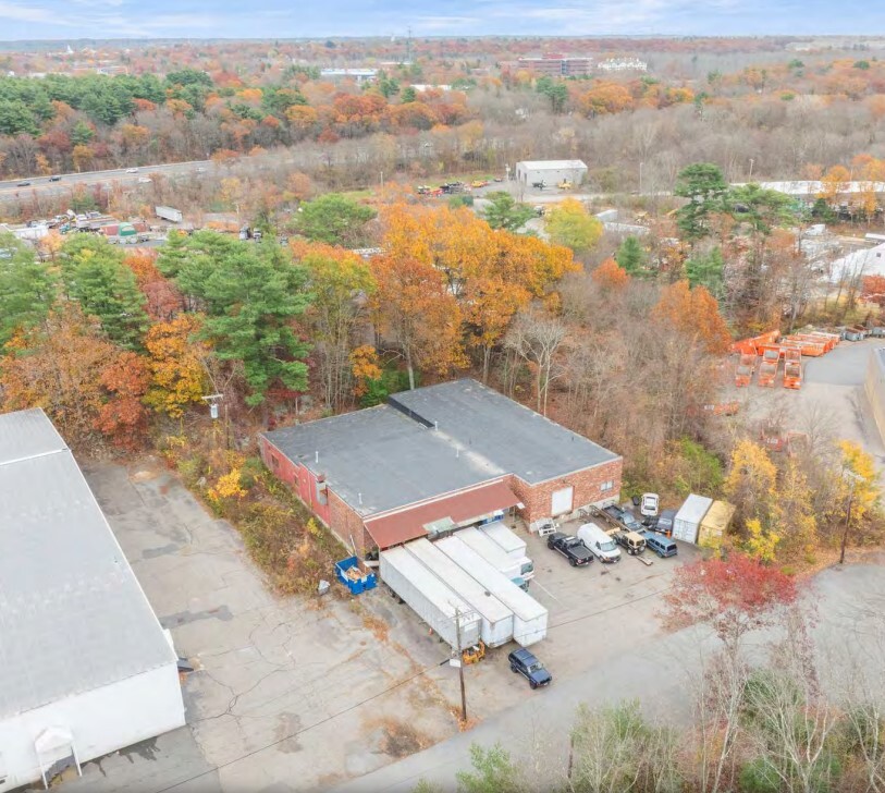
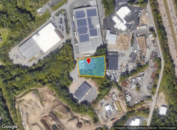
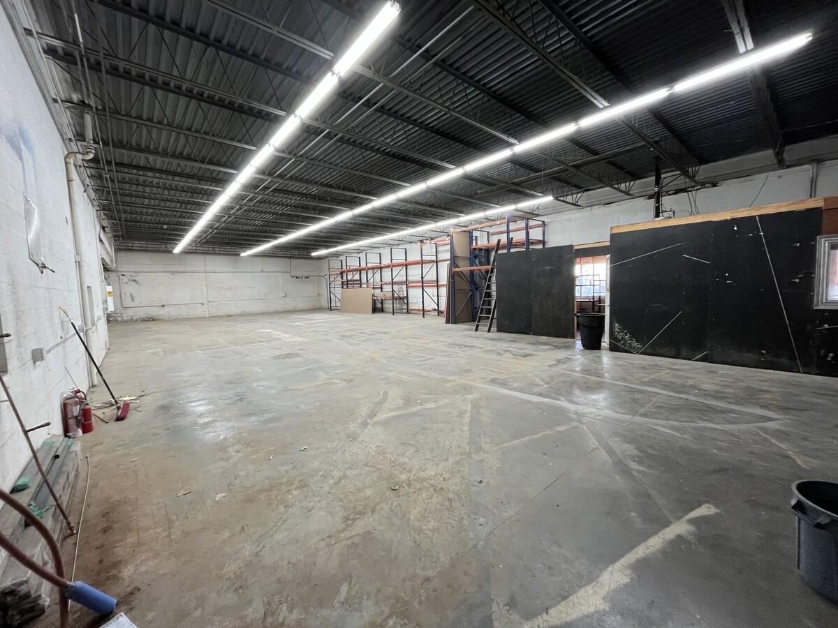
Property Record
8 Carver Cir, Canton, MA 02021
Current Lease Availabilities
NEARBY LISTINGS FOR SALE OR LEASE
-
-
-
-
-
-
703-705 Technology Center Dr
Stoughton, MA 02072
$15.00 - $16.00 SF/YR
13,000 - 27,000 SF
Industrial
-
-
View all Canton listings for lease on LoopNet.com
Property Detail
8 Carver Cir
Warehouse
Norfolk
ARE
Massachusetts
25021C0212E
1.10 AC
2024
Route 24
2024
Boston
415201
Boston-Cambridge-Newton, MA-NH
9,804 SF
CANT-000115-000000-000024
DEMOGRAPHICS near 8 Carver Cir
1 Mile
3 Mile
5 Mile
2024 Total Population
4,421
57,338
141,718
2029 Population
4,399
56,709
140,508
Pop Growth 2024-2029
(0.50%)
(1.10%)
(0.85%)
Average Age
42
42
42
2024 Total Households
1,619
21,115
52,718
HH Growth 2024-2029
(0.56%)
(1.18%)
(0.90%)
Median Household Inc
$104,415
$91,821
$98,357
Avg Household Size
2.70
2.60
2.60
2024 Avg HH Vehicles
2.00
2.00
2.00
Median Home Value
$527,467
$460,073
$475,420
Median Year Built
1983
1966
1965
Nearby Places
- Restaurants
- Banks
- Shops
- Fitness
- Groceries
PUBLIC TRANSPORTATION
COMMUTER RAIL
Stoughton (Providence/Stoughton Line - Massachusetts Bay Transportation Authority Commuter Rail (Purple Line))
DRIVE
WALK
Distance
Stoughton (Providence/Stoughton Line - Massachusetts Bay Transportation Authority Commuter Rail (Purple Line))
9 min
3.9 mi
Holbrook/Randolph (Middleborough/Lakeville Line - Massachusetts Bay Transportation Authority Commuter Rail (Purple Line))
DRIVE
WALK
Distance
Holbrook/Randolph (Middleborough/Lakeville Line - Massachusetts Bay Transportation Authority Commuter Rail (Purple Line))
10 min
4.2 mi
AIRPORT
General Edward Lawrence Logan International
DRIVE
WALK
Distance
General Edward Lawrence Logan International
35 min
21.3 mi
Freight Ports
Port of Boston
DRIVE
WALK
Distance
Port of Boston
32 min
19.1 mi
Nearby Properties
Address
Land Use
TOTAL SIZE
Lot Size
Zoning
Address
Land Use
TOTAL SIZE
Lot Size
Zoning
26,430 SF
38.40 AC
RMFD
Address
Land Use
TOTAL SIZE
Lot Size
Zoning
154,871 SF
34.30 AC
SRAA
Address
Land Use
TOTAL SIZE
Lot Size
Zoning
23.20 AC
RH
Address
Land Use
TOTAL SIZE
Lot Size
Zoning
37,252 SF
44.33 AC
SRAA
Address
Land Use
TOTAL SIZE
Lot Size
Zoning
13.08 AC
HB
Address
Land Use
TOTAL SIZE
Lot Size
Zoning
140,489 SF
36.47 AC
SRB
Address
Land Use
TOTAL SIZE
Lot Size
Zoning
543,189 SF
22.90 AC
LI
Address
Land Use
TOTAL SIZE
Lot Size
Zoning
70,216 SF
6.86 AC
PROSD
Address
Land Use
TOTAL SIZE
Lot Size
Zoning
1,728 SF
40.20 AC
LI
Address
Land Use
TOTAL SIZE
Lot Size
Zoning
417,014 SF
10 AC
LI
Address
Land Use
TOTAL SIZE
Lot Size
Zoning
38,616 SF
160 AC
PROSD
Address
Land Use
TOTAL SIZE
Lot Size
Zoning
132,143 SF
23.70 AC
RH
Address
Land Use
TOTAL SIZE
Lot Size
Zoning
199,072 SF
10.07 AC
HB
Address
Land Use
TOTAL SIZE
Lot Size
Zoning
86,564 SF
8.45 AC
GBHD
Address
Land Use
TOTAL SIZE
Lot Size
Zoning
403,163 SF
24.58 AC
I
Address
Land Use
TOTAL SIZE
Lot Size
Zoning
10.10 AC
CSBD
Address
Land Use
TOTAL SIZE
Lot Size
Zoning
160,716 SF
18.87 AC
SRB
Address
Land Use
TOTAL SIZE
Lot Size
Zoning
7.27 AC
GB
Address
Land Use
TOTAL SIZE
Lot Size
Zoning
128,753 SF
17.50 AC
SRAA
Address
Land Use
TOTAL SIZE
Lot Size
Zoning
138,400 SF
55.71 AC
RM
Address
Land Use
TOTAL SIZE
Lot Size
Zoning
114,176 SF
11.69 AC
RH
Address
Land Use
TOTAL SIZE
Lot Size
Zoning
298,820 SF
19.65 AC
LI
Address
Land Use
TOTAL SIZE
Lot Size
Zoning
208,122 SF
20.30 AC
RU
Address
Land Use
TOTAL SIZE
Lot Size
Zoning
289,562 SF
13.59 AC
Address
Land Use
TOTAL SIZE
Lot Size
Zoning
34.45 AC
HB
Address
Land Use
TOTAL SIZE
Lot Size
Zoning
133,125 SF
16.13 AC
PROSD
Address
Land Use
TOTAL SIZE
Lot Size
Zoning
128,760 SF
19.51 AC
LI
Address
Land Use
TOTAL SIZE
Lot Size
Zoning
136,836 SF
16 AC
A
Address
Land Use
TOTAL SIZE
Lot Size
Zoning
13,671 SF
592.70 AC
PROSD
Address
Land Use
TOTAL SIZE
Lot Size
Zoning
121,424 SF
11.11 AC
HB
The World's #1 Commercial Real Estate Marketplace
Connect with us
© 2025 CoStar Group
The information above has been obtained from sources believed reliable. While we do not doubt its accuracy we have not verified it and make no guarantee, warranty or representation about it. It is your responsibility to independently confirm its accuracy and completeness. Any projections, opinions, assumptions, or estimates used are for example only and do not represent the current or future performance of the property. The value of this transaction to you depends on tax and other factors which should be evaluated by your tax, financial, and legal advisors. You and your advisors should conduct a careful, independent investigation of the property to determine to your satisfaction the suitability of the property for your needs.