Property Record
80 W 22 Hwy, Milledgeville, GA 31061
NEARBY LISTINGS FOR SALE OR LEASE
-
-
View all Milledgeville listings for sale on LoopNet.com
Property Detail
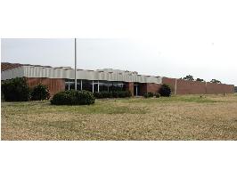
80 W 22 Hwy
052-030
Comm County $5000
Officebuilding
UTILITY R-W NDR UTILITY R/W DB 1091-463
X
Baldwin
13009C0135D
Georgia
0
25.98 AC
2024
Georgia South Area
970400
Other Market Areas
9,648 SF
Milledgeville, GA
DEMOGRAPHICS near 80 W 22 Hwy
1 Mile
3 Mile
5 Mile
2024 Total Population
4
8,182
25,420
2029 Population
4
8,079
25,390
Pop Growth 2024-2029
0.00%
(1.26%)
(0.12%)
Average Age
20
38
38
2024 Total Households
1
3,361
10,029
HH Growth 2024-2029
0.00%
(1.55%)
(0.17%)
Median Household Inc
$0
$41,339
$38,604
Avg Household Size
.00
2.20
2.30
2024 Avg HH Vehicles
.00
2.00
2.00
Median Home Value
$0
$162,132
$158,995
Median Year Built
0
1982
1979
Nearby Places
- Restaurants
- Banks
- Shops
- Fitness
- Groceries
Nearby Properties
Address
Land Use
TOTAL SIZE
Lot Size
Zoning
Address
Land Use
TOTAL SIZE
Lot Size
Zoning
29.65 AC
RESIDENTIA
Address
Land Use
TOTAL SIZE
Lot Size
Zoning
59,500 SF
44 AC
RESIDENTIA
Address
Land Use
TOTAL SIZE
Lot Size
Zoning
430,556 SF
32.09 AC
RESIDENTIA
Address
Land Use
TOTAL SIZE
Lot Size
Zoning
74,448 SF
49 AC
RESIDENTIA
Address
Land Use
TOTAL SIZE
Lot Size
Zoning
21,775 SF
30 AC
RESIDENTIA
Address
Land Use
TOTAL SIZE
Lot Size
Zoning
49,412 SF
0.26 AC
RESIDENTIA
Address
Land Use
TOTAL SIZE
Lot Size
Zoning
313,804 SF
17.50 AC
RESIDENTIA
Address
Land Use
TOTAL SIZE
Lot Size
Zoning
30.05 AC
RESIDENTIA
Address
Land Use
TOTAL SIZE
Lot Size
Zoning
66,430 SF
14.93 AC
COMMERCIAL
Address
Land Use
TOTAL SIZE
Lot Size
Zoning
228,844 SF
3.20 AC
RESIDENTIA
Address
Land Use
TOTAL SIZE
Lot Size
Zoning
554,286 SF
24.17 AC
RESIDENTIA
Address
Land Use
TOTAL SIZE
Lot Size
Zoning
6,318 SF
27.92 AC
RESIDENTIA
Address
Land Use
TOTAL SIZE
Lot Size
Zoning
76,800 SF
0.86 AC
UNZONED UR
Address
Land Use
TOTAL SIZE
Lot Size
Zoning
46,858 SF
2.64 AC
RESIDENTIA
Address
Land Use
TOTAL SIZE
Lot Size
Zoning
50,580 SF
7.61 AC
COMMERCIAL
Address
Land Use
TOTAL SIZE
Lot Size
Zoning
76,582 SF
3.17 AC
RESIDENTIA
Address
Land Use
TOTAL SIZE
Lot Size
Zoning
37,296 SF
13.50 AC
RESIDENTIA
Address
Land Use
TOTAL SIZE
Lot Size
Zoning
17,980 SF
2.30 AC
COMMERCIAL
Address
Land Use
TOTAL SIZE
Lot Size
Zoning
160,604 SF
8.29 AC
RESIDENTIA
Address
Land Use
TOTAL SIZE
Lot Size
Zoning
7,764 SF
10 AC
UNZONED RU
Address
Land Use
TOTAL SIZE
Lot Size
Zoning
172,008 SF
2.31 AC
RESIDENTIA
Address
Land Use
TOTAL SIZE
Lot Size
Zoning
1,006.83 AC
UNZONED RU
Address
Land Use
TOTAL SIZE
Lot Size
Zoning
136,469 SF
6.44 AC
RESIDENTIA
Address
Land Use
TOTAL SIZE
Lot Size
Zoning
90,888 SF
1.01 AC
RESIDENTIA
Address
Land Use
TOTAL SIZE
Lot Size
Zoning
43,282 SF
1.54 AC
COMMERCIAL
Address
Land Use
TOTAL SIZE
Lot Size
Zoning
118,521 SF
1.86 AC
RESIDENTIA
Address
Land Use
TOTAL SIZE
Lot Size
Zoning
109,308 SF
6.15 AC
RESIDENTIA
Address
Land Use
TOTAL SIZE
Lot Size
Zoning
60,055 SF
4.14 AC
COMMERCIAL
Address
Land Use
TOTAL SIZE
Lot Size
Zoning
18,936 SF
7.60 AC
RESIDENTIA
The World's #1 Commercial Real Estate Marketplace
Connect with us
© 2025 CoStar Group
The information above has been obtained from sources believed reliable. While we do not doubt its accuracy we have not verified it and make no guarantee, warranty or representation about it. It is your responsibility to independently confirm its accuracy and completeness. Any projections, opinions, assumptions, or estimates used are for example only and do not represent the current or future performance of the property. The value of this transaction to you depends on tax and other factors which should be evaluated by your tax, financial, and legal advisors. You and your advisors should conduct a careful, independent investigation of the property to determine to your satisfaction the suitability of the property for your needs.