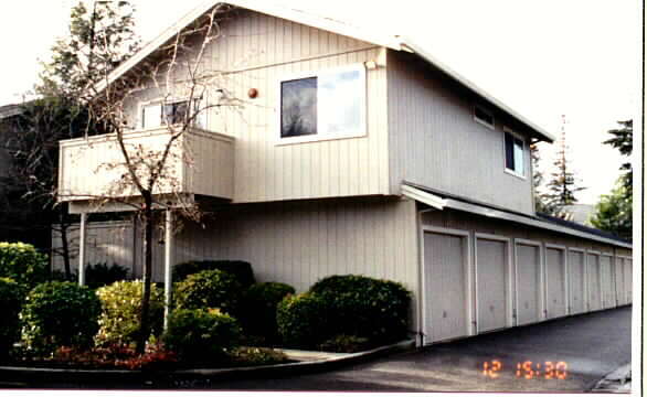
Property Record
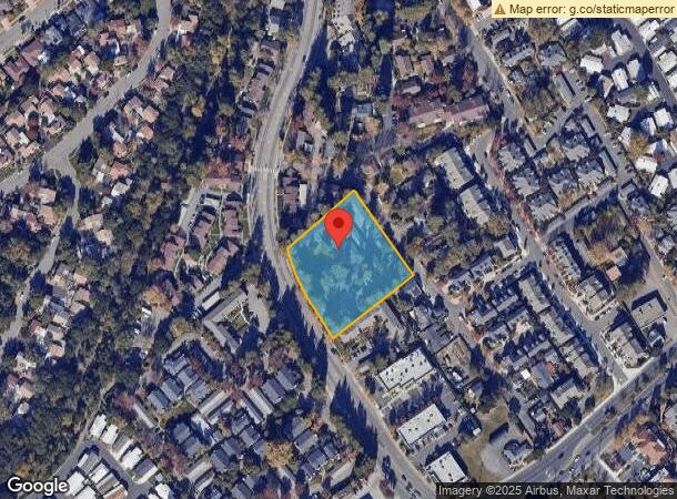
800 Mission Blvd, Santa Rosa, CA 95409
NEARBY LISTINGS FOR SALE OR LEASE
Property Detail
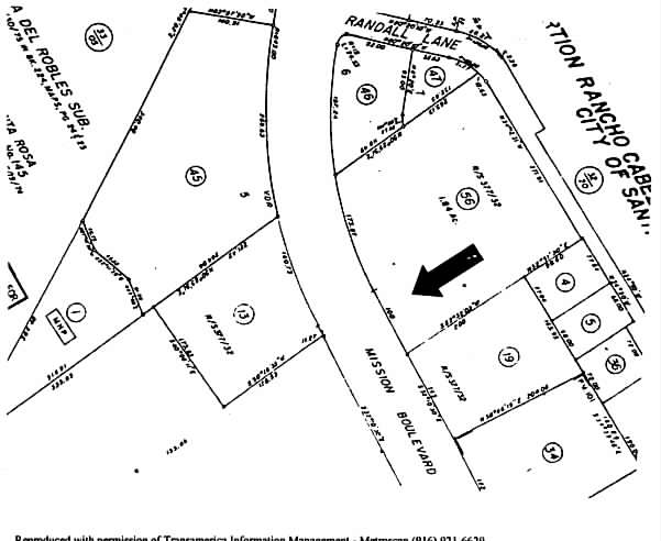
800 Mission Blvd
182-490-006
Rancho Cabeza De Santa Rosa
Apartment
REMAP FROM 145-310-056-000 - 08/11/98
X
Sonoma
06097C0733E
California
2023
1.84 AC
2023
Outer Santa Rosa
152204
North Bay/Santa Rosa
28,285 SF
Santa Rosa, CA
DEMOGRAPHICS near 800 Mission Blvd
1 Mile
3 Mile
5 Mile
2024 Total Population
13,909
82,304
178,867
2029 Population
13,748
81,809
177,770
Pop Growth 2024-2029
(1.16%)
(0.60%)
(0.61%)
Average Age
44
44
42
2024 Total Households
5,768
33,695
67,302
HH Growth 2024-2029
(1.18%)
(0.61%)
(0.58%)
Median Household Inc
$88,667
$97,241
$90,002
Avg Household Size
2.30
2.40
2.60
2024 Avg HH Vehicles
2.00
2.00
2.00
Median Home Value
$769,626
$785,028
$728,490
Median Year Built
1978
1974
1979
Nearby Places
- Restaurants
- Banks
- Shops
- Fitness
- Groceries
PUBLIC TRANSPORTATION
COMMUTER RAIL
Santa Rosa Downtown Smart (Main Line - Sonoma Marin Area Rail Transit)
DRIVE
WALK
Distance
Santa Rosa Downtown Smart (Main Line - Sonoma Marin Area Rail Transit)
7 min
3.6 mi
Santa Rosa North Smart (Main Line - Sonoma Marin Area Rail Transit)
DRIVE
WALK
Distance
Santa Rosa North Smart (Main Line - Sonoma Marin Area Rail Transit)
9 min
4.8 mi
AIRPORT
Charles M Schulz - Sonoma County
DRIVE
WALK
Distance
Charles M Schulz - Sonoma County
17 min
10.7 mi
Freight Ports
Port of Richmond
DRIVE
WALK
Distance
Port of Richmond
68 min
51.8 mi
Nearby Properties
Address
Land Use
TOTAL SIZE
Lot Size
Zoning
Address
Land Use
TOTAL SIZE
Lot Size
Zoning
695,457 SF
128.68 AC
CITYSR
Address
Land Use
TOTAL SIZE
Lot Size
Zoning
258,134 SF
7.42 AC
CITYSR
Address
Land Use
TOTAL SIZE
Lot Size
Zoning
22.45 AC
MCPD
Address
Land Use
TOTAL SIZE
Lot Size
Zoning
434,911 SF
30.22 AC
Address
Land Use
TOTAL SIZE
Lot Size
Zoning
Address
Land Use
TOTAL SIZE
Lot Size
Zoning
441,698 SF
10.23 AC
C2
Address
Land Use
TOTAL SIZE
Lot Size
Zoning
447,600 SF
22 AC
Address
Land Use
TOTAL SIZE
Lot Size
Zoning
178,704 SF
10.76 AC
CITYSR
Address
Land Use
TOTAL SIZE
Lot Size
Zoning
131,210 SF
10.41 AC
Address
Land Use
TOTAL SIZE
Lot Size
Zoning
90,079 SF
3.09 AC
Address
Land Use
TOTAL SIZE
Lot Size
Zoning
107,765 SF
5.70 AC
CITYSR
Address
Land Use
TOTAL SIZE
Lot Size
Zoning
191,385 SF
13.77 AC
C2P
Address
Land Use
TOTAL SIZE
Lot Size
Zoning
146,611 SF
9.44 AC
Address
Land Use
TOTAL SIZE
Lot Size
Zoning
89,168 SF
5.50 AC
CITYSR
Address
Land Use
TOTAL SIZE
Lot Size
Zoning
122,645 SF
9.46 AC
CITYSR
Address
Land Use
TOTAL SIZE
Lot Size
Zoning
29,397 SF
6.33 AC
Address
Land Use
TOTAL SIZE
Lot Size
Zoning
58,551 SF
4.24 AC
Address
Land Use
TOTAL SIZE
Lot Size
Zoning
181,593 SF
6.71 AC
R3PD
Address
Land Use
TOTAL SIZE
Lot Size
Zoning
161,466 SF
13.82 AC
CITYSR
Address
Land Use
TOTAL SIZE
Lot Size
Zoning
33,698 SF
2.94 AC
CITYSR
Address
Land Use
TOTAL SIZE
Lot Size
Zoning
131,502 SF
8.60 AC
Address
Land Use
TOTAL SIZE
Lot Size
Zoning
128,092 SF
7.12 AC
Address
Land Use
TOTAL SIZE
Lot Size
Zoning
56,151 SF
4.21 AC
Address
Land Use
TOTAL SIZE
Lot Size
Zoning
62,088 SF
3.80 AC
PC
Address
Land Use
TOTAL SIZE
Lot Size
Zoning
1.94 AC
CITYSR
Address
Land Use
TOTAL SIZE
Lot Size
Zoning
52,764 SF
3.56 AC
Address
Land Use
TOTAL SIZE
Lot Size
Zoning
103,894 SF
4.27 AC
CITYSR
Address
Land Use
TOTAL SIZE
Lot Size
Zoning
78,155 SF
6.57 AC
CITYSR
Address
Land Use
TOTAL SIZE
Lot Size
Zoning
50,520 SF
3.73 AC
CITYSR
Address
Land Use
TOTAL SIZE
Lot Size
Zoning
99,362 SF
0.77 AC
CITYSR
The World's #1 Commercial Real Estate Marketplace
Connect with us
© 2025 CoStar Group
The information above has been obtained from sources believed reliable. While we do not doubt its accuracy we have not verified it and make no guarantee, warranty or representation about it. It is your responsibility to independently confirm its accuracy and completeness. Any projections, opinions, assumptions, or estimates used are for example only and do not represent the current or future performance of the property. The value of this transaction to you depends on tax and other factors which should be evaluated by your tax, financial, and legal advisors. You and your advisors should conduct a careful, independent investigation of the property to determine to your satisfaction the suitability of the property for your needs.