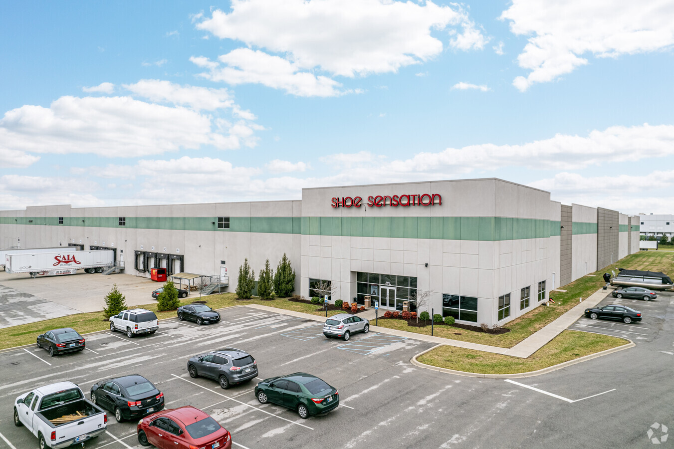
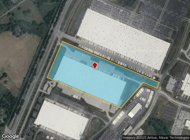
Property Record
800 Patrol Rd, Jeffersonville, IN 47130
NEARBY LISTINGS FOR SALE OR LEASE
Property Detail
800 Patrol Rd
10-42-05-200-007.000-039
GTS 52 & 53-- TRACT D-1 37.481 AC
Warehouse
Clark
X
Indiana
18019C0190E
37.48 AC
2023
Outlying Clark County
2023
Louisville
050706
Louisville-Jefferson County, KY-IN
667,972 SF
DEMOGRAPHICS near 800 Patrol Rd
1 Mile
3 Mile
5 Mile
2024 Total Population
1,220
10,811
61,554
2029 Population
1,319
11,574
65,263
Pop Growth 2024-2029
+ 8.11%
+ 7.06%
+ 6.03%
Average Age
38
39
40
2024 Total Households
440
4,042
24,027
HH Growth 2024-2029
+ 8.18%
+ 7.05%
+ 6.03%
Median Household Inc
$101,310
$94,796
$74,587
Avg Household Size
2.70
2.60
2.50
2024 Avg HH Vehicles
2.00
2.00
2.00
Median Home Value
$189,782
$249,190
$219,705
Median Year Built
2007
2005
1994
Nearby Places
- Restaurants
- Banks
- Shops
- Fitness
- Groceries
PUBLIC TRANSPORTATION
AIRPORT
Louisville Muhammad Ali International
DRIVE
WALK
Distance
Louisville Muhammad Ali International
31 min
17.7 mi
Freight Ports
Port of Toledo
DRIVE
WALK
Distance
Port of Toledo
353 min
304.3 mi
SALE & LEASE HISTORY
LISTING DATE
SALE/LEASE

Sep 24, 2016
For Sale
Jan 04, 2017
For Lease
Nearby Properties
Address
Land Use
TOTAL SIZE
Lot Size
Zoning
Address
Land Use
TOTAL SIZE
Lot Size
Zoning
948,552 SF
70.58 AC
Address
Land Use
TOTAL SIZE
Lot Size
Zoning
1,102,160 SF
65.70 AC
Address
Land Use
TOTAL SIZE
Lot Size
Zoning
4,361 SF
18.18 AC
Address
Land Use
TOTAL SIZE
Lot Size
Zoning
659,100 SF
36.44 AC
Address
Land Use
TOTAL SIZE
Lot Size
Zoning
620,000 SF
33.95 AC
Address
Land Use
TOTAL SIZE
Lot Size
Zoning
Address
Land Use
TOTAL SIZE
Lot Size
Zoning
607,500 SF
34.89 AC
Address
Land Use
TOTAL SIZE
Lot Size
Zoning
592,800 SF
33.72 AC
Address
Land Use
TOTAL SIZE
Lot Size
Zoning
500,000 SF
24.99 AC
Address
Land Use
TOTAL SIZE
Lot Size
Zoning
470,244 SF
21.11 AC
Address
Land Use
TOTAL SIZE
Lot Size
Zoning
12.89 AC
Address
Land Use
TOTAL SIZE
Lot Size
Zoning
427,988 SF
21.89 AC
Address
Land Use
TOTAL SIZE
Lot Size
Zoning
507,456 SF
11.50 AC
Address
Land Use
TOTAL SIZE
Lot Size
Zoning
448,950 SF
30.44 AC
Address
Land Use
TOTAL SIZE
Lot Size
Zoning
460,600 SF
32.96 AC
Address
Land Use
TOTAL SIZE
Lot Size
Zoning
312,078 SF
26.82 AC
Address
Land Use
TOTAL SIZE
Lot Size
Zoning
Address
Land Use
TOTAL SIZE
Lot Size
Zoning
8,752 SF
19.78 AC
Address
Land Use
TOTAL SIZE
Lot Size
Zoning
435,095 SF
22.66 AC
Address
Land Use
TOTAL SIZE
Lot Size
Zoning
499,500 SF
30.26 AC
Address
Land Use
TOTAL SIZE
Lot Size
Zoning
Address
Land Use
TOTAL SIZE
Lot Size
Zoning
257,335 SF
18.71 AC
Address
Land Use
TOTAL SIZE
Lot Size
Zoning
250,025 SF
20.88 AC
Address
Land Use
TOTAL SIZE
Lot Size
Zoning
113,602 SF
7.54 AC
Address
Land Use
TOTAL SIZE
Lot Size
Zoning
197,784 SF
11.09 AC
Address
Land Use
TOTAL SIZE
Lot Size
Zoning
292,500 SF
22.36 AC
Address
Land Use
TOTAL SIZE
Lot Size
Zoning
200,675 SF
29.31 AC
Address
Land Use
TOTAL SIZE
Lot Size
Zoning
82,827 SF
13.61 AC
Address
Land Use
TOTAL SIZE
Lot Size
Zoning
15.99 AC
The World's #1 Commercial Real Estate Marketplace
Connect with us
© 2025 CoStar Group
The information above has been obtained from sources believed reliable. While we do not doubt its accuracy we have not verified it and make no guarantee, warranty or representation about it. It is your responsibility to independently confirm its accuracy and completeness. Any projections, opinions, assumptions, or estimates used are for example only and do not represent the current or future performance of the property. The value of this transaction to you depends on tax and other factors which should be evaluated by your tax, financial, and legal advisors. You and your advisors should conduct a careful, independent investigation of the property to determine to your satisfaction the suitability of the property for your needs.