Property Record
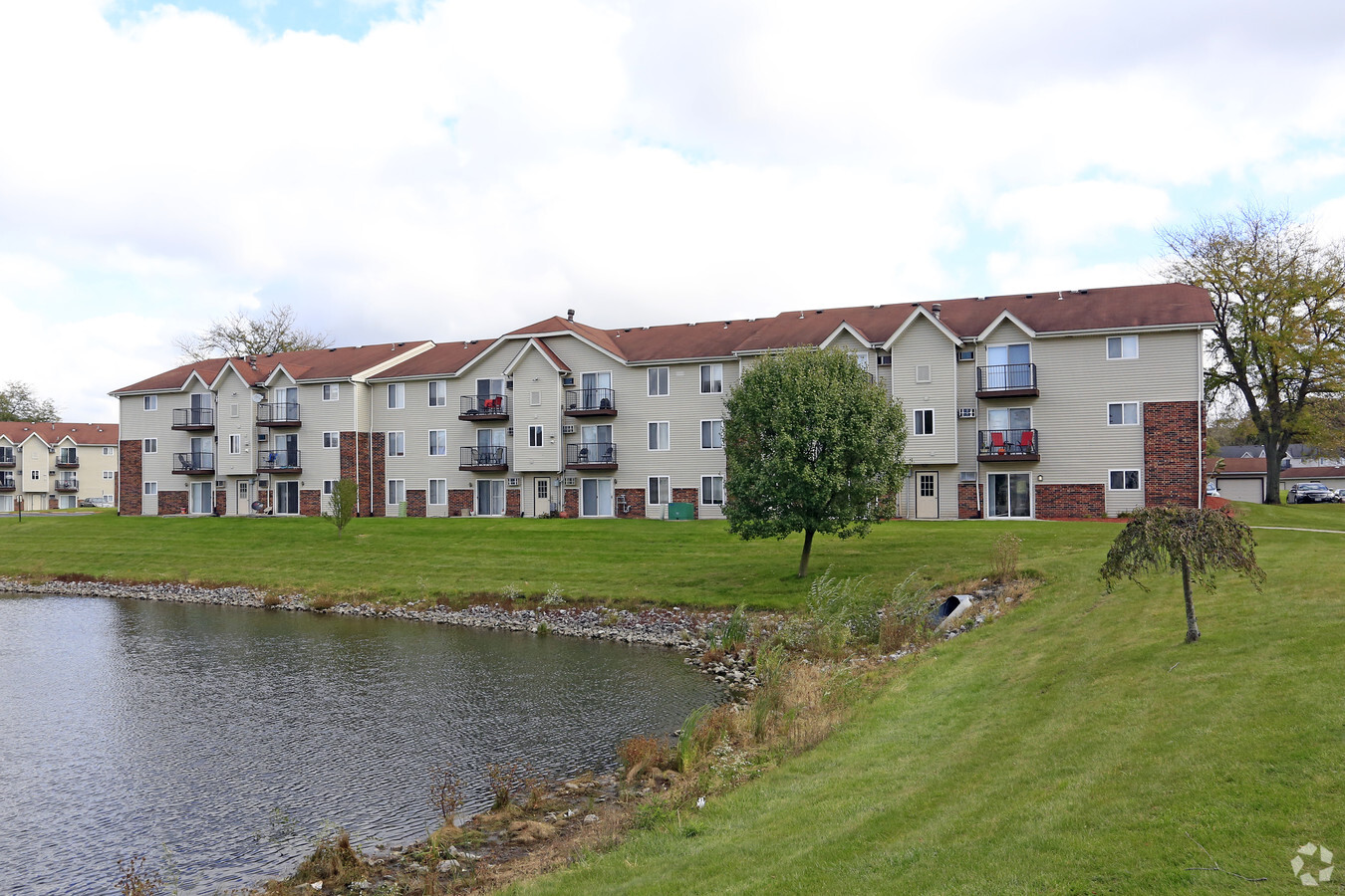
8005 Pine Island Dr, Schererville, IN 46375
NEARBY LISTINGS FOR SALE OR LEASE
-
-
View all Schererville listings for sale on LoopNet.com
Property Detail
8005 Pine Island Dr
45-11-24-279-001.000-036
PT OF E 1/2 E 1/2 S.24 T.35 R.9 LY G S. OF U.S. #30 & PT K/A PAR #1 & NELY OF PINE ISLAND DRIVE. A/K/A PARCEL #2 9.00 AC
Apartment
Lake
X
Indiana
18089C0232E
1
2023
7.74 AC
2024
South Lake County
042704
Chicago
87,264 SF
Chicago-Naperville-Elgin, IL-IN-WI
DEMOGRAPHICS near 8005 Pine Island Dr
1 Mile
3 Mile
5 Mile
2024 Total Population
8,524
46,211
118,112
2029 Population
8,482
46,100
118,189
Pop Growth 2024-2029
(0.49%)
(0.24%)
+ 0.07%
Average Age
39
42
42
2024 Total Households
3,445
18,241
47,135
HH Growth 2024-2029
(0.55%)
(0.23%)
+ 0.03%
Median Household Inc
$69,985
$76,445
$73,214
Avg Household Size
2.40
2.40
2.40
2024 Avg HH Vehicles
2.00
2.00
2.00
Median Home Value
$240,740
$233,828
$231,302
Median Year Built
1984
1987
1979
Nearby Places
- Restaurants
- Banks
- Shops
- Fitness
- Groceries
PUBLIC TRANSPORTATION
COMMUTER RAIL
Dyer Amtrak (Cardinal - Amtrak)
DRIVE
WALK
Distance
Dyer Amtrak (Cardinal - Amtrak)
16 min
8.5 mi
AIRPORT
Chicago Midway International
DRIVE
WALK
Distance
Chicago Midway International
59 min
36.7 mi
Freight Ports
Port Milwaukee
DRIVE
WALK
Distance
Port Milwaukee
162 min
123.0 mi
Nearby Properties
Address
Land Use
TOTAL SIZE
Lot Size
Zoning
Address
Land Use
TOTAL SIZE
Lot Size
Zoning
206,854 SF
8.38 AC
Address
Land Use
TOTAL SIZE
Lot Size
Zoning
536,896 SF
20.08 AC
Address
Land Use
TOTAL SIZE
Lot Size
Zoning
377,878 SF
21.58 AC
Address
Land Use
TOTAL SIZE
Lot Size
Zoning
365,748 SF
17.44 AC
R33
Address
Land Use
TOTAL SIZE
Lot Size
Zoning
289,840 SF
15.31 AC
Address
Land Use
TOTAL SIZE
Lot Size
Zoning
100,659 SF
3.89 AC
Address
Land Use
TOTAL SIZE
Lot Size
Zoning
236,904 SF
11.30 AC
R33
Address
Land Use
TOTAL SIZE
Lot Size
Zoning
116,352 SF
9 AC
Address
Land Use
TOTAL SIZE
Lot Size
Zoning
116,352 SF
8.08 AC
Address
Land Use
TOTAL SIZE
Lot Size
Zoning
132,147 SF
44.38 AC
R33
Address
Land Use
TOTAL SIZE
Lot Size
Zoning
190,352 SF
12.36 AC
Address
Land Use
TOTAL SIZE
Lot Size
Zoning
304,429 SF
84.07 AC
Address
Land Use
TOTAL SIZE
Lot Size
Zoning
237,291 SF
33.51 AC
R33
Address
Land Use
TOTAL SIZE
Lot Size
Zoning
45,397 SF
14.48 AC
Address
Land Use
TOTAL SIZE
Lot Size
Zoning
125,172 SF
5.57 AC
R33
Address
Land Use
TOTAL SIZE
Lot Size
Zoning
66,464 SF
43.30 AC
Address
Land Use
TOTAL SIZE
Lot Size
Zoning
52,896 SF
4.06 AC
R33
Address
Land Use
TOTAL SIZE
Lot Size
Zoning
41,015 SF
4.87 AC
Address
Land Use
TOTAL SIZE
Lot Size
Zoning
26,738 SF
4.67 AC
Address
Land Use
TOTAL SIZE
Lot Size
Zoning
42,090 SF
4.04 AC
Address
Land Use
TOTAL SIZE
Lot Size
Zoning
49,184 SF
28.68 AC
Address
Land Use
TOTAL SIZE
Lot Size
Zoning
81,568 SF
9.31 AC
Address
Land Use
TOTAL SIZE
Lot Size
Zoning
29,654 SF
7.81 AC
R33
Address
Land Use
TOTAL SIZE
Lot Size
Zoning
33,876 SF
15.14 AC
Address
Land Use
TOTAL SIZE
Lot Size
Zoning
112,309 SF
7.24 AC
Address
Land Use
TOTAL SIZE
Lot Size
Zoning
17,500 SF
2.11 AC
R33
Address
Land Use
TOTAL SIZE
Lot Size
Zoning
97,674 SF
29.16 AC
Address
Land Use
TOTAL SIZE
Lot Size
Zoning
112,059 SF
8.75 AC
Address
Land Use
TOTAL SIZE
Lot Size
Zoning
43,401 SF
7.17 AC
The World's #1 Commercial Real Estate Marketplace
Connect with us
© 2025 CoStar Group
The information above has been obtained from sources believed reliable. While we do not doubt its accuracy we have not verified it and make no guarantee, warranty or representation about it. It is your responsibility to independently confirm its accuracy and completeness. Any projections, opinions, assumptions, or estimates used are for example only and do not represent the current or future performance of the property. The value of this transaction to you depends on tax and other factors which should be evaluated by your tax, financial, and legal advisors. You and your advisors should conduct a careful, independent investigation of the property to determine to your satisfaction the suitability of the property for your needs.