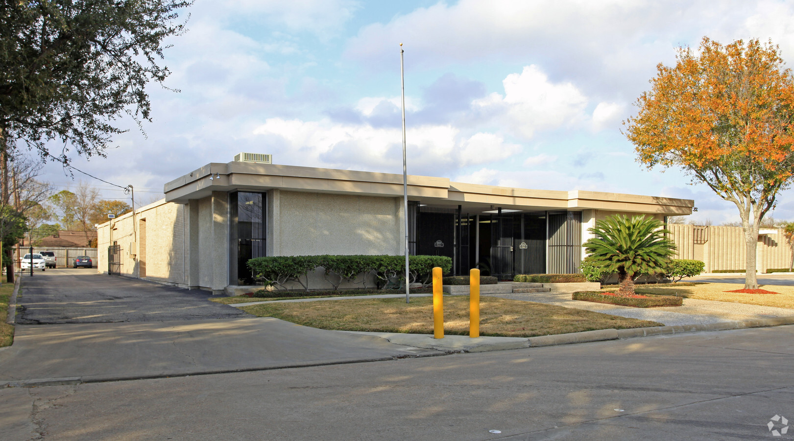
Property Record
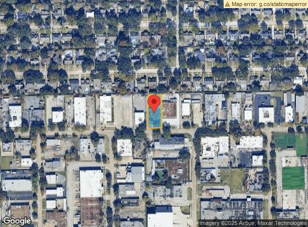
8020 Westglen Dr, Houston, TX 77063
Current Lease Availabilities
NEARBY LISTINGS FOR SALE OR LEASE
Property Detail
8020 Westglen Dr
0942710000001
Westpark Center Sec 1
Warehouse
TR 1B BLK 1 WESTPARK CENTER SEC 1
X
Harris
48157C0175L
Texas
2023
0.48 AC
2023
Richmond/Fountainview
432600
Houston
8,276 SF
Houston-The Woodlands-Sugar Land, TX
DEMOGRAPHICS near 8020 Westglen Dr
1 Mile
3 Mile
5 Mile
2024 Total Population
23,198
246,856
570,295
2029 Population
23,693
253,899
586,678
Pop Growth 2024-2029
+ 2.13%
+ 2.85%
+ 2.87%
Average Age
34
36
37
2024 Total Households
9,577
104,663
237,359
HH Growth 2024-2029
+ 2.13%
+ 2.84%
+ 2.93%
Median Household Inc
$35,215
$48,029
$56,809
Avg Household Size
2.30
2.30
2.30
2024 Avg HH Vehicles
1.00
1.00
2.00
Median Home Value
$312,734
$342,424
$460,955
Median Year Built
1975
1978
1980
Nearby Places
- Restaurants
- Banks
- Shops
- Fitness
- Groceries
PUBLIC TRANSPORTATION
AIRPORT
William P Hobby
DRIVE
WALK
Distance
William P Hobby
34 min
20.2 mi
George Bush Intcntl/Houston
DRIVE
WALK
Distance
George Bush Intcntl/Houston
39 min
28.9 mi
Freight Ports
Port of Houston
DRIVE
WALK
Distance
Port of Houston
31 min
19.5 mi
Nearby Properties
Address
Land Use
TOTAL SIZE
Lot Size
Zoning
Address
Land Use
TOTAL SIZE
Lot Size
Zoning
2,626,393 SF
6.70 AC
Address
Land Use
TOTAL SIZE
Lot Size
Zoning
576,253 SF
5.91 AC
Address
Land Use
TOTAL SIZE
Lot Size
Zoning
329,832 SF
1.75 AC
Address
Land Use
TOTAL SIZE
Lot Size
Zoning
1,062,592 SF
7.41 AC
Address
Land Use
TOTAL SIZE
Lot Size
Zoning
576,200 SF
2.65 AC
Address
Land Use
TOTAL SIZE
Lot Size
Zoning
515,215 SF
2.58 AC
Address
Land Use
TOTAL SIZE
Lot Size
Zoning
1,020,766 SF
3.08 AC
Address
Land Use
TOTAL SIZE
Lot Size
Zoning
305,760 SF
2.22 AC
Address
Land Use
TOTAL SIZE
Lot Size
Zoning
1,819,963 SF
5.30 AC
Address
Land Use
TOTAL SIZE
Lot Size
Zoning
323,456 SF
3.91 AC
Address
Land Use
TOTAL SIZE
Lot Size
Zoning
878,129 SF
11.69 AC
Address
Land Use
TOTAL SIZE
Lot Size
Zoning
702,286 SF
15.67 AC
Address
Land Use
TOTAL SIZE
Lot Size
Zoning
385,587 SF
3.08 AC
Address
Land Use
TOTAL SIZE
Lot Size
Zoning
561,732 SF
6.10 AC
Address
Land Use
TOTAL SIZE
Lot Size
Zoning
1,083,841 SF
6.43 AC
Address
Land Use
TOTAL SIZE
Lot Size
Zoning
521,287 SF
3.90 AC
Address
Land Use
TOTAL SIZE
Lot Size
Zoning
649,992 SF
19.81 AC
Address
Land Use
TOTAL SIZE
Lot Size
Zoning
597,397 SF
2.93 AC
Address
Land Use
TOTAL SIZE
Lot Size
Zoning
812,087 SF
28.58 AC
Address
Land Use
TOTAL SIZE
Lot Size
Zoning
1,106,930 SF
4.65 AC
Address
Land Use
TOTAL SIZE
Lot Size
Zoning
972,984 SF
30.18 AC
Address
Land Use
TOTAL SIZE
Lot Size
Zoning
582,660 SF
6.96 AC
Address
Land Use
TOTAL SIZE
Lot Size
Zoning
589,957 SF
5.30 AC
Address
Land Use
TOTAL SIZE
Lot Size
Zoning
281,973 SF
11.56 AC
Address
Land Use
TOTAL SIZE
Lot Size
Zoning
511,262 SF
6.60 AC
Address
Land Use
TOTAL SIZE
Lot Size
Zoning
2,231,696 SF
4 AC
Address
Land Use
TOTAL SIZE
Lot Size
Zoning
445,293 SF
2.64 AC
Address
Land Use
TOTAL SIZE
Lot Size
Zoning
128,404 SF
2.88 AC
Address
Land Use
TOTAL SIZE
Lot Size
Zoning
654,788 SF
17.58 AC
Address
Land Use
TOTAL SIZE
Lot Size
Zoning
361,954 SF
14.43 AC
The World's #1 Commercial Real Estate Marketplace
Connect with us
© 2025 CoStar Group
The information above has been obtained from sources believed reliable. While we do not doubt its accuracy we have not verified it and make no guarantee, warranty or representation about it. It is your responsibility to independently confirm its accuracy and completeness. Any projections, opinions, assumptions, or estimates used are for example only and do not represent the current or future performance of the property. The value of this transaction to you depends on tax and other factors which should be evaluated by your tax, financial, and legal advisors. You and your advisors should conduct a careful, independent investigation of the property to determine to your satisfaction the suitability of the property for your needs.