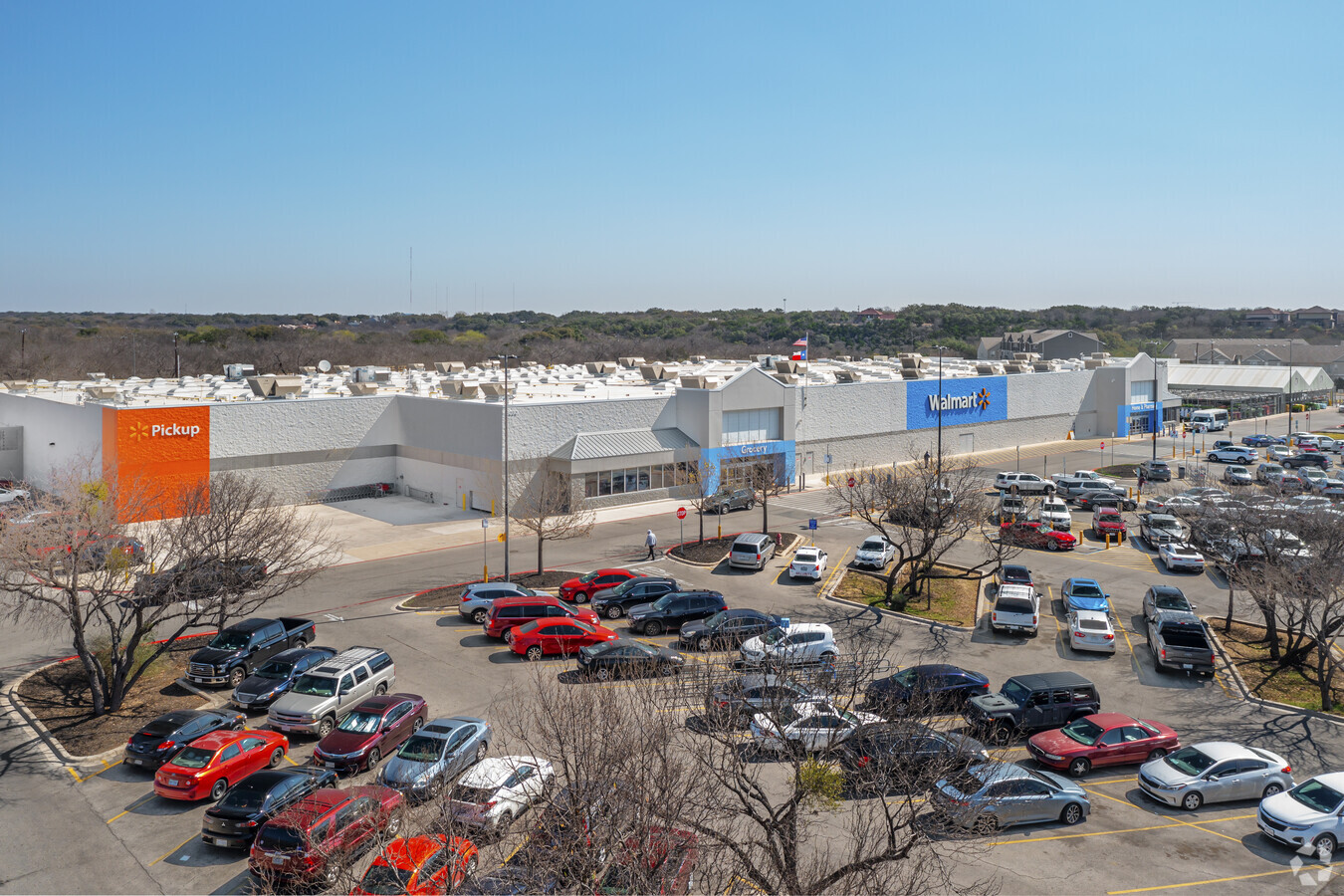
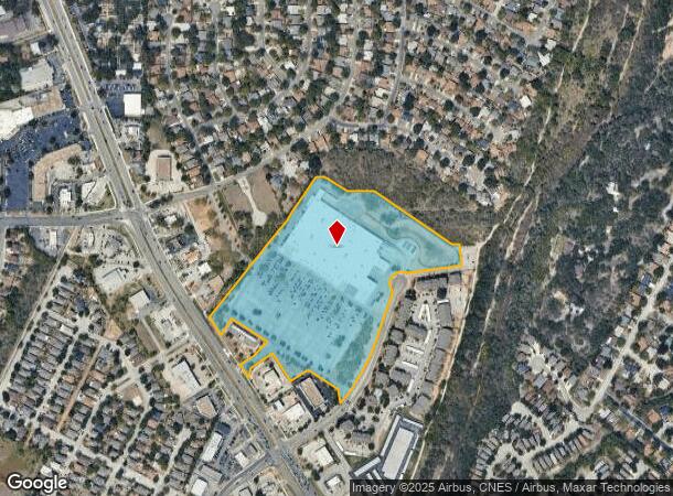
Property Record
8022 Bandera Rd, San Antonio, TX 78250

NEARBY LISTINGS FOR SALE OR LEASE
Property Detail
8022 Bandera Rd
San Antonio-New Braunfels, TX
Conv A/S Code
17975-000-0140
NCB 17975 BLK LOT 14 EXC NW MID IRR 216.6 FT & EXC N IRR 205.22 FT (WALMART-BANDERA @ MAINLAND) 2009-REMAINS PER SPLIT PER PLAT 9589/211-214 FILED 4-24-08 AND DEED 13690/1984 EXE 9-19-08
Warehouse
Bexar
X
Texas
48029C0220G
14
2023
24.57 AC
2023
Northwest
181731
San Antonio
205,848 SF
DEMOGRAPHICS near 8022 Bandera Rd
1 Mile
3 Mile
5 Mile
2024 Total Population
9,947
134,893
349,777
2029 Population
10,472
142,281
370,049
Pop Growth 2024-2029
+ 5.28%
+ 5.48%
+ 5.80%
Average Age
40
38
36
2024 Total Households
3,852
53,216
138,700
HH Growth 2024-2029
+ 5.40%
+ 5.76%
+ 6.10%
Median Household Inc
$63,277
$70,177
$63,922
Avg Household Size
2.50
2.50
2.40
2024 Avg HH Vehicles
2.00
2.00
2.00
Median Home Value
$212,477
$219,512
$219,277
Median Year Built
1987
1989
1990
Nearby Places
- Restaurants
- Banks
- Shops
- Fitness
- Groceries
PUBLIC TRANSPORTATION
AIRPORT
San Antonio International
DRIVE
WALK
Distance
San Antonio International
18 min
12.2 mi
Freight Ports
Calhoun Port
DRIVE
WALK
Distance
Calhoun Port
200 min
160.3 mi
Nearby Properties
Address
Land Use
TOTAL SIZE
Lot Size
Zoning
Address
Land Use
TOTAL SIZE
Lot Size
Zoning
352,231 SF
19.54 AC
Address
Land Use
TOTAL SIZE
Lot Size
Zoning
284,359 SF
21.53 AC
Address
Land Use
TOTAL SIZE
Lot Size
Zoning
305,600 SF
30.64 AC
Address
Land Use
TOTAL SIZE
Lot Size
Zoning
301,817 SF
12.22 AC
Address
Land Use
TOTAL SIZE
Lot Size
Zoning
495,484 SF
5.81 AC
Address
Land Use
TOTAL SIZE
Lot Size
Zoning
264,676 SF
11.91 AC
Address
Land Use
TOTAL SIZE
Lot Size
Zoning
308,010 SF
9.93 AC
Address
Land Use
TOTAL SIZE
Lot Size
Zoning
8,508 SF
3.34 AC
Address
Land Use
TOTAL SIZE
Lot Size
Zoning
272,456 SF
21.53 AC
Address
Land Use
TOTAL SIZE
Lot Size
Zoning
232,398 SF
12.66 AC
Address
Land Use
TOTAL SIZE
Lot Size
Zoning
220,719 SF
25.86 AC
Address
Land Use
TOTAL SIZE
Lot Size
Zoning
299,088 SF
15.66 AC
Address
Land Use
TOTAL SIZE
Lot Size
Zoning
211,182 SF
6.73 AC
Address
Land Use
TOTAL SIZE
Lot Size
Zoning
252,361 SF
14.35 AC
Address
Land Use
TOTAL SIZE
Lot Size
Zoning
340,653 SF
19.27 AC
Address
Land Use
TOTAL SIZE
Lot Size
Zoning
291,385 SF
16.19 AC
Address
Land Use
TOTAL SIZE
Lot Size
Zoning
191,361 SF
15.02 AC
Address
Land Use
TOTAL SIZE
Lot Size
Zoning
230,048 SF
10.70 AC
Address
Land Use
TOTAL SIZE
Lot Size
Zoning
221,778 SF
16.31 AC
Address
Land Use
TOTAL SIZE
Lot Size
Zoning
176,718 SF
4.62 AC
Address
Land Use
TOTAL SIZE
Lot Size
Zoning
215,505 SF
11.21 AC
Address
Land Use
TOTAL SIZE
Lot Size
Zoning
237,245 SF
11.74 AC
Address
Land Use
TOTAL SIZE
Lot Size
Zoning
246,381 SF
10.56 AC
Address
Land Use
TOTAL SIZE
Lot Size
Zoning
219,292 SF
6.85 AC
Address
Land Use
TOTAL SIZE
Lot Size
Zoning
134,240 SF
5.76 AC
Address
Land Use
TOTAL SIZE
Lot Size
Zoning
177,539 SF
8.87 AC
Address
Land Use
TOTAL SIZE
Lot Size
Zoning
194,289 SF
13.32 AC
Address
Land Use
TOTAL SIZE
Lot Size
Zoning
147,376 SF
14.86 AC
Address
Land Use
TOTAL SIZE
Lot Size
Zoning
37,500 SF
3.58 AC
Address
Land Use
TOTAL SIZE
Lot Size
Zoning
212,038 SF
14.44 AC
The World's #1 Commercial Real Estate Marketplace
Connect with us
© 2025 CoStar Group
The information above has been obtained from sources believed reliable. While we do not doubt its accuracy we have not verified it and make no guarantee, warranty or representation about it. It is your responsibility to independently confirm its accuracy and completeness. Any projections, opinions, assumptions, or estimates used are for example only and do not represent the current or future performance of the property. The value of this transaction to you depends on tax and other factors which should be evaluated by your tax, financial, and legal advisors. You and your advisors should conduct a careful, independent investigation of the property to determine to your satisfaction the suitability of the property for your needs.