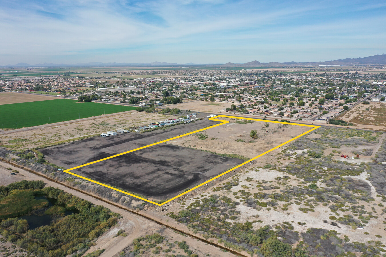
Property Record
803 E Beloat Rd, Buckeye, AZ 85326
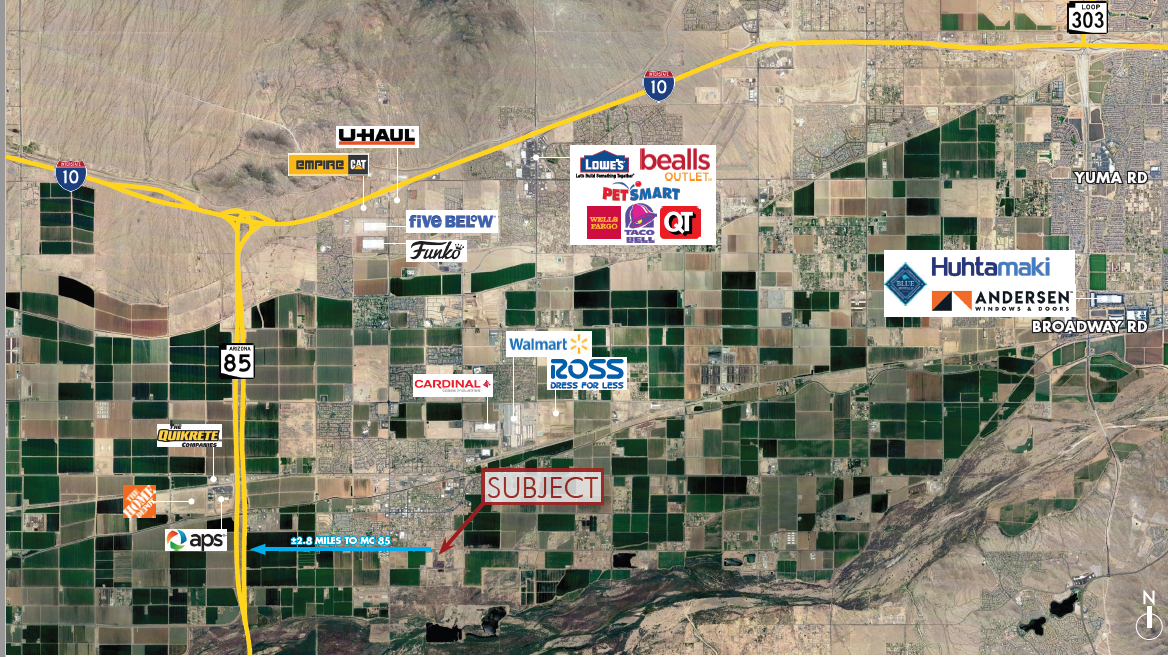
NEARBY LISTINGS FOR SALE OR LEASE
Property Detail
803 E Beloat Rd
400-42-007F
TH PT OF NW4 NE4 BEG NE COR OF SEC 8 TH W ALG N LN OF SD SEC 1489.91F TPOB TH S 1320F TH W 363.79 F TH N 1111.29F TH E 125.22F TH N 38D 27M E 25.26 F TH N 193F TO A PT N LN OF SD NW4 NE4 TH E ALG N LN 218.79F TO TPOB EX N 33F RD
Industrialgeneral
Maricopa
AE
Arizona
04013C2580M
10.22 AC
2024
Southwest Outlying
2025
Phoenix
050617
Phoenix-Mesa-Scottsdale, AZ
5,090 SF
DEMOGRAPHICS near 803 E Beloat Rd
1 Mile
3 Mile
5 Mile
2024 Total Population
4,213
22,355
37,341
2029 Population
4,602
24,257
40,812
Pop Growth 2024-2029
+ 9.23%
+ 8.51%
+ 9.30%
Average Age
35
33
34
2024 Total Households
1,420
6,763
11,073
HH Growth 2024-2029
+ 9.23%
+ 8.61%
+ 9.38%
Median Household Inc
$52,692
$65,054
$69,597
Avg Household Size
2.90
3.30
3.30
2024 Avg HH Vehicles
2.00
2.00
2.00
Median Home Value
$217,662
$255,776
$266,135
Median Year Built
1990
2004
2005
Nearby Places
- Restaurants
- Banks
- Shops
- Fitness
- Groceries
SALE & LEASE HISTORY
LISTING DATE
SALE/LEASE

Nov 07, 2022
For Sale
Nearby Properties
Address
Land Use
TOTAL SIZE
Lot Size
Zoning
Address
Land Use
TOTAL SIZE
Lot Size
Zoning
2,310,631 SF
215.58 AC
Address
Land Use
TOTAL SIZE
Lot Size
Zoning
1,207,360 SF
67.69 AC
Address
Land Use
TOTAL SIZE
Lot Size
Zoning
1,834,456 SF
142.44 AC
C-G
Address
Land Use
TOTAL SIZE
Lot Size
Zoning
3,494 SF
6.20 AC
GC
Address
Land Use
TOTAL SIZE
Lot Size
Zoning
510,427 SF
64.69 AC
GC
Address
Land Use
TOTAL SIZE
Lot Size
Zoning
290,752 SF
21.32 AC
SU
Address
Land Use
TOTAL SIZE
Lot Size
Zoning
122,714 SF
12.27 AC
C-C
Address
Land Use
TOTAL SIZE
Lot Size
Zoning
68,255 SF
3.16 AC
PUD
Address
Land Use
TOTAL SIZE
Lot Size
Zoning
85,712 SF
15.18 AC
PR
Address
Land Use
TOTAL SIZE
Lot Size
Zoning
5,597 SF
164.45 AC
PR
Address
Land Use
TOTAL SIZE
Lot Size
Zoning
228,652 SF
136.91 AC
SU
Address
Land Use
TOTAL SIZE
Lot Size
Zoning
60,201 SF
14.10 AC
PUD
Address
Land Use
TOTAL SIZE
Lot Size
Zoning
125,120 SF
8.49 AC
SU
Address
Land Use
TOTAL SIZE
Lot Size
Zoning
181,308 SF
20.19 AC
C-G
Address
Land Use
TOTAL SIZE
Lot Size
Zoning
20,248 SF
23.16 AC
SU
Address
Land Use
TOTAL SIZE
Lot Size
Zoning
188,937 SF
20.87 AC
Address
Land Use
TOTAL SIZE
Lot Size
Zoning
178,939 SF
13.98 AC
CC
Address
Land Use
TOTAL SIZE
Lot Size
Zoning
150,139 SF
20.48 AC
C-G
Address
Land Use
TOTAL SIZE
Lot Size
Zoning
136,836 SF
8.85 AC
R-R
Address
Land Use
TOTAL SIZE
Lot Size
Zoning
53.11 AC
C-G
Address
Land Use
TOTAL SIZE
Lot Size
Zoning
40,859 SF
6.92 AC
PUD
Address
Land Use
TOTAL SIZE
Lot Size
Zoning
24,119 SF
5.12 AC
CC
Address
Land Use
TOTAL SIZE
Lot Size
Zoning
32,567 SF
7.38 AC
PR
Address
Land Use
TOTAL SIZE
Lot Size
Zoning
16,502 SF
2.26 AC
C-C
Address
Land Use
TOTAL SIZE
Lot Size
Zoning
10,815 SF
8.06 AC
SU
Address
Land Use
TOTAL SIZE
Lot Size
Zoning
36,051 SF
46 AC
R-R
Address
Land Use
TOTAL SIZE
Lot Size
Zoning
15,452 SF
6.50 AC
C-G
Address
Land Use
TOTAL SIZE
Lot Size
Zoning
11.41 AC
PAD
Address
Land Use
TOTAL SIZE
Lot Size
Zoning
21,000 SF
3.66 AC
C-C
Address
Land Use
TOTAL SIZE
Lot Size
Zoning
25,572 SF
2.81 AC
SU
The World's #1 Commercial Real Estate Marketplace
Connect with us
© 2025 CoStar Group
The information above has been obtained from sources believed reliable. While we do not doubt its accuracy we have not verified it and make no guarantee, warranty or representation about it. It is your responsibility to independently confirm its accuracy and completeness. Any projections, opinions, assumptions, or estimates used are for example only and do not represent the current or future performance of the property. The value of this transaction to you depends on tax and other factors which should be evaluated by your tax, financial, and legal advisors. You and your advisors should conduct a careful, independent investigation of the property to determine to your satisfaction the suitability of the property for your needs.