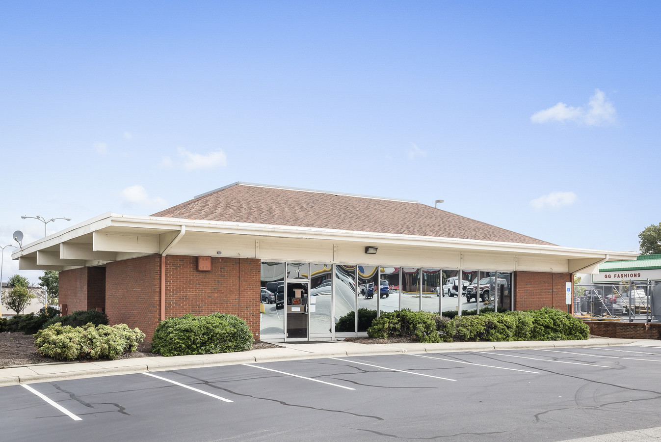
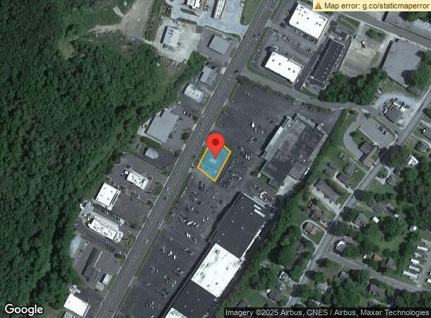
Property Record
804 N Madison Blvd, Roxboro, NC 27573

NEARBY LISTINGS FOR SALE OR LEASE
Property Detail
804 N Madison Blvd
6-38C
Property Of Westfield Company
Financialbuilding
804 N MADISON BLVD BANK
X
Person
3720090600K
North Carolina
2023
0.34 AC
2024
Person County
920300
Raleigh/Durham
3,048 SF
Durham-Chapel Hill, NC
DEMOGRAPHICS near 804 N Madison Blvd
1 Mile
3 Mile
5 Mile
2024 Total Population
3,494
12,386
18,398
2029 Population
3,603
12,778
18,970
Pop Growth 2024-2029
+ 3.12%
+ 3.16%
+ 3.11%
Average Age
40
42
42
2024 Total Households
1,523
5,239
7,717
HH Growth 2024-2029
+ 3.15%
+ 3.13%
+ 3.08%
Median Household Inc
$34,207
$40,844
$45,978
Avg Household Size
2.20
2.30
2.30
2024 Avg HH Vehicles
1.00
2.00
2.00
Median Home Value
$112,207
$134,677
$141,899
Median Year Built
1968
1972
1977
Nearby Places
- Restaurants
- Banks
- Shops
- Fitness
- Groceries
SALE & LEASE HISTORY
LISTING DATE
SALE/LEASE

May 02, 2018
For Sale
Jan 07, 2020
For Lease
Jan 07, 2020
For Sale
Nearby Properties
Address
Land Use
TOTAL SIZE
Lot Size
Zoning
Address
Land Use
TOTAL SIZE
Lot Size
Zoning
200,964 SF
42.79 AC
Address
Land Use
TOTAL SIZE
Lot Size
Zoning
54,132 SF
42.03 AC
Address
Land Use
TOTAL SIZE
Lot Size
Zoning
112,896 SF
8.82 AC
Address
Land Use
TOTAL SIZE
Lot Size
Zoning
23,040 SF
173 AC
Address
Land Use
TOTAL SIZE
Lot Size
Zoning
153,823 SF
19.76 AC
Address
Land Use
TOTAL SIZE
Lot Size
Zoning
71,339 SF
6.65 AC
RC
Address
Land Use
TOTAL SIZE
Lot Size
Zoning
105,170 SF
17.68 AC
Address
Land Use
TOTAL SIZE
Lot Size
Zoning
43,101 SF
20.63 AC
Address
Land Use
TOTAL SIZE
Lot Size
Zoning
70,797 SF
34.92 AC
Address
Land Use
TOTAL SIZE
Lot Size
Zoning
968 SF
10 AC
Address
Land Use
TOTAL SIZE
Lot Size
Zoning
62,596 SF
40 AC
Address
Land Use
TOTAL SIZE
Lot Size
Zoning
86,968 SF
11.53 AC
Address
Land Use
TOTAL SIZE
Lot Size
Zoning
63,360 SF
1.26 AC
Address
Land Use
TOTAL SIZE
Lot Size
Zoning
14,595 SF
20 AC
Address
Land Use
TOTAL SIZE
Lot Size
Zoning
22,292 SF
2.76 AC
Address
Land Use
TOTAL SIZE
Lot Size
Zoning
9,464 SF
0.42 AC
Address
Land Use
TOTAL SIZE
Lot Size
Zoning
15,460 SF
3.36 AC
Address
Land Use
TOTAL SIZE
Lot Size
Zoning
3,596 SF
14.89 AC
Address
Land Use
TOTAL SIZE
Lot Size
Zoning
11,660 SF
3 AC
Address
Land Use
TOTAL SIZE
Lot Size
Zoning
23,813 SF
0.42 AC
Address
Land Use
TOTAL SIZE
Lot Size
Zoning
18,556 SF
2.59 AC
Address
Land Use
TOTAL SIZE
Lot Size
Zoning
41,229 SF
1.79 AC
Address
Land Use
TOTAL SIZE
Lot Size
Zoning
40,784 SF
0.96 AC
Address
Land Use
TOTAL SIZE
Lot Size
Zoning
31,600 SF
11.50 AC
Address
Land Use
TOTAL SIZE
Lot Size
Zoning
32,728 SF
2.71 AC
Address
Land Use
TOTAL SIZE
Lot Size
Zoning
42,733 SF
3.44 AC
Address
Land Use
TOTAL SIZE
Lot Size
Zoning
21,120 SF
2.10 AC
Address
Land Use
TOTAL SIZE
Lot Size
Zoning
5,157 SF
10 AC
Address
Land Use
TOTAL SIZE
Lot Size
Zoning
1,100 SF
10 AC
Address
Land Use
TOTAL SIZE
Lot Size
Zoning
29,100 SF
3.38 AC
The World's #1 Commercial Real Estate Marketplace
Connect with us
© 2025 CoStar Group
The information above has been obtained from sources believed reliable. While we do not doubt its accuracy we have not verified it and make no guarantee, warranty or representation about it. It is your responsibility to independently confirm its accuracy and completeness. Any projections, opinions, assumptions, or estimates used are for example only and do not represent the current or future performance of the property. The value of this transaction to you depends on tax and other factors which should be evaluated by your tax, financial, and legal advisors. You and your advisors should conduct a careful, independent investigation of the property to determine to your satisfaction the suitability of the property for your needs.