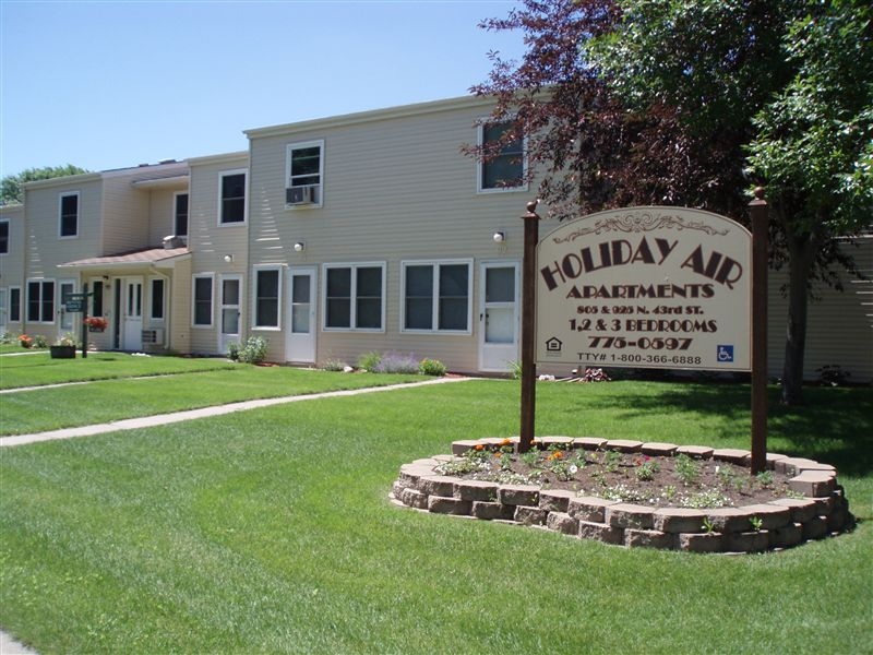
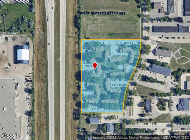
Property Record
805 N 43Rd St, Grand Forks, ND 58203
NEARBY LISTINGS FOR SALE OR LEASE
Property Detail
805 N 43Rd St
Grand Forks, ND-MN
Replat Of Airport Addition
44111500010000
805,901,925 N. 43RD LOT 3 B 3
Commercialnec
Grand Forks
X
North Dakota
38035C0587E
3
2023
6.04 AC
2023
North Dakota Area
010400
Other Market Areas
89,668 SF
DEMOGRAPHICS near 805 N 43Rd St
1 Mile
3 Mile
5 Mile
2024 Total Population
10,340
41,200
67,713
2029 Population
10,302
40,798
66,981
Pop Growth 2024-2029
(0.37%)
(0.98%)
(1.08%)
Average Age
28
35
36
2024 Total Households
3,612
17,648
28,844
HH Growth 2024-2029
(0.33%)
(1.10%)
(1.18%)
Median Household Inc
$34,288
$52,503
$59,402
Avg Household Size
2.20
2.10
2.20
2024 Avg HH Vehicles
2.00
2.00
2.00
Median Home Value
$200,681
$197,535
$236,016
Median Year Built
1993
1980
1981
Nearby Places
- Restaurants
- Banks
- Shops
- Fitness
- Groceries
PUBLIC TRANSPORTATION
COMMUTER RAIL
Grand Forks Amtrak Station (Empire Builder - Amtrak)
DRIVE
WALK
Distance
Grand Forks Amtrak Station (Empire Builder - Amtrak)
5 min
2.0 mi
AIRPORT
Grand Forks International
DRIVE
WALK
Distance
Grand Forks International
10 min
5.5 mi
Freight Ports
Port Milwaukee
DRIVE
WALK
Distance
Port Milwaukee
714 min
652.0 mi
Nearby Properties
Address
Land Use
TOTAL SIZE
Lot Size
Zoning
Address
Land Use
TOTAL SIZE
Lot Size
Zoning
Address
Land Use
TOTAL SIZE
Lot Size
Zoning
16.53 AC
Address
Land Use
TOTAL SIZE
Lot Size
Zoning
181,020 SF
13.50 AC
Address
Land Use
TOTAL SIZE
Lot Size
Zoning
172,013 SF
8.14 AC
Address
Land Use
TOTAL SIZE
Lot Size
Zoning
198,253 SF
2.76 AC
Address
Land Use
TOTAL SIZE
Lot Size
Zoning
173,317 SF
15.40 AC
Address
Land Use
TOTAL SIZE
Lot Size
Zoning
189,378 SF
19.04 AC
Address
Land Use
TOTAL SIZE
Lot Size
Zoning
147,161 SF
4.22 AC
Address
Land Use
TOTAL SIZE
Lot Size
Zoning
19.06 AC
Address
Land Use
TOTAL SIZE
Lot Size
Zoning
159,975 SF
12.90 AC
Address
Land Use
TOTAL SIZE
Lot Size
Zoning
185,550 SF
14.10 AC
Address
Land Use
TOTAL SIZE
Lot Size
Zoning
Address
Land Use
TOTAL SIZE
Lot Size
Zoning
53,181 SF
6.46 AC
Address
Land Use
TOTAL SIZE
Lot Size
Zoning
152,729 SF
9.44 AC
Address
Land Use
TOTAL SIZE
Lot Size
Zoning
140,040 SF
6.33 AC
Address
Land Use
TOTAL SIZE
Lot Size
Zoning
157,264 SF
5.99 AC
Address
Land Use
TOTAL SIZE
Lot Size
Zoning
148,083 SF
7.35 AC
Address
Land Use
TOTAL SIZE
Lot Size
Zoning
129,480 SF
10.85 AC
Address
Land Use
TOTAL SIZE
Lot Size
Zoning
158,412 SF
8.91 AC
Address
Land Use
TOTAL SIZE
Lot Size
Zoning
Address
Land Use
TOTAL SIZE
Lot Size
Zoning
Address
Land Use
TOTAL SIZE
Lot Size
Zoning
119,267 SF
4.10 AC
Address
Land Use
TOTAL SIZE
Lot Size
Zoning
56,280 SF
10.50 AC
Address
Land Use
TOTAL SIZE
Lot Size
Zoning
Address
Land Use
TOTAL SIZE
Lot Size
Zoning
124,007 SF
10.63 AC
Address
Land Use
TOTAL SIZE
Lot Size
Zoning
151,770 SF
10.99 AC
Address
Land Use
TOTAL SIZE
Lot Size
Zoning
Address
Land Use
TOTAL SIZE
Lot Size
Zoning
283,271 SF
21.61 AC
Address
Land Use
TOTAL SIZE
Lot Size
Zoning
97,497 SF
3.87 AC
Address
Land Use
TOTAL SIZE
Lot Size
Zoning
52,782 SF
2.74 AC
The World's #1 Commercial Real Estate Marketplace
Connect with us
© 2025 CoStar Group
The information above has been obtained from sources believed reliable. While we do not doubt its accuracy we have not verified it and make no guarantee, warranty or representation about it. It is your responsibility to independently confirm its accuracy and completeness. Any projections, opinions, assumptions, or estimates used are for example only and do not represent the current or future performance of the property. The value of this transaction to you depends on tax and other factors which should be evaluated by your tax, financial, and legal advisors. You and your advisors should conduct a careful, independent investigation of the property to determine to your satisfaction the suitability of the property for your needs.