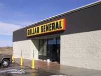
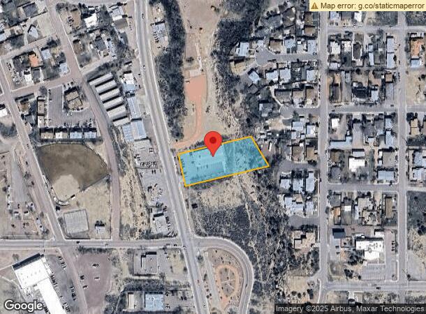
Property Record
805 S Second St, Gallup, NM 87301
NEARBY LISTINGS FOR SALE OR LEASE
Property Detail
805 S Second St
Gallup, NM
Burke George Heights Addn
R300678
LOT 2, REPLAT NO. 1 OF A PORTION OF BLOCK B AND BLOCK C, BURKE GEORGE HEIGHTS ADDN. CONT. 1.27 ACS M/L FINAL PLAT IN BK 25 PG 5976 10/3/05 BK 26 PGS 8373-74 5/19/06 CODE #2-105-087-449-427 P500558
Commercialnec
Mckinley
AE
New Mexico
35031C1540E
2
2024
1.27 AC
2024
Other Market Areas
945400
DEMOGRAPHICS near 805 S Second St
1 Mile
3 Mile
5 Mile
2024 Total Population
8,006
19,476
24,043
2029 Population
7,764
18,746
23,052
Pop Growth 2024-2029
(3.02%)
(3.75%)
(4.12%)
Average Age
38
37
37
2024 Total Households
3,123
6,793
8,263
HH Growth 2024-2029
(2.82%)
(3.50%)
(3.90%)
Median Household Inc
$55,334
$51,783
$53,333
Avg Household Size
2.50
2.70
2.80
2024 Avg HH Vehicles
2.00
2.00
2.00
Median Home Value
$154,804
$123,722
$121,123
Median Year Built
1968
1974
1976
Nearby Places
- Restaurants
- Banks
- Shops
- Fitness
- Groceries
PUBLIC TRANSPORTATION
COMMUTER RAIL
Gallup Amtrak Station (Southwest Chief - Amtrak)
DRIVE
WALK
Distance
Gallup Amtrak Station (Southwest Chief - Amtrak)
1 min
14 min
0.7 mi
Freight Ports
Port of San Diego
DRIVE
WALK
Distance
Port of San Diego
721 min
673.0 mi
Nearby Properties
Address
Land Use
TOTAL SIZE
Lot Size
Zoning
Address
Land Use
TOTAL SIZE
Lot Size
Zoning
23.14 AC
Address
Land Use
TOTAL SIZE
Lot Size
Zoning
2.15 AC
Address
Land Use
TOTAL SIZE
Lot Size
Zoning
17.68 AC
Address
Land Use
TOTAL SIZE
Lot Size
Zoning
Address
Land Use
TOTAL SIZE
Lot Size
Zoning
1.43 AC
Address
Land Use
TOTAL SIZE
Lot Size
Zoning
11.85 AC
Address
Land Use
TOTAL SIZE
Lot Size
Zoning
Address
Land Use
TOTAL SIZE
Lot Size
Zoning
7.17 AC
Address
Land Use
TOTAL SIZE
Lot Size
Zoning
2.33 AC
Address
Land Use
TOTAL SIZE
Lot Size
Zoning
Address
Land Use
TOTAL SIZE
Lot Size
Zoning
Address
Land Use
TOTAL SIZE
Lot Size
Zoning
1.26 AC
Address
Land Use
TOTAL SIZE
Lot Size
Zoning
Address
Land Use
TOTAL SIZE
Lot Size
Zoning
0.97 AC
Address
Land Use
TOTAL SIZE
Lot Size
Zoning
7.38 AC
Address
Land Use
TOTAL SIZE
Lot Size
Zoning
Address
Land Use
TOTAL SIZE
Lot Size
Zoning
1.98 AC
Address
Land Use
TOTAL SIZE
Lot Size
Zoning
3.17 AC
Address
Land Use
TOTAL SIZE
Lot Size
Zoning
Address
Land Use
TOTAL SIZE
Lot Size
Zoning
1.40 AC
Address
Land Use
TOTAL SIZE
Lot Size
Zoning
1.48 AC
Address
Land Use
TOTAL SIZE
Lot Size
Zoning
7.49 AC
Address
Land Use
TOTAL SIZE
Lot Size
Zoning
0.60 AC
Address
Land Use
TOTAL SIZE
Lot Size
Zoning
3.31 AC
Address
Land Use
TOTAL SIZE
Lot Size
Zoning
5.93 AC
Address
Land Use
TOTAL SIZE
Lot Size
Zoning
Address
Land Use
TOTAL SIZE
Lot Size
Zoning
1.95 AC
Address
Land Use
TOTAL SIZE
Lot Size
Zoning
Address
Land Use
TOTAL SIZE
Lot Size
Zoning
The World's #1 Commercial Real Estate Marketplace
Connect with us
© 2025 CoStar Group
The information above has been obtained from sources believed reliable. While we do not doubt its accuracy we have not verified it and make no guarantee, warranty or representation about it. It is your responsibility to independently confirm its accuracy and completeness. Any projections, opinions, assumptions, or estimates used are for example only and do not represent the current or future performance of the property. The value of this transaction to you depends on tax and other factors which should be evaluated by your tax, financial, and legal advisors. You and your advisors should conduct a careful, independent investigation of the property to determine to your satisfaction the suitability of the property for your needs.