Property Record
806 W Diamond Ave, Gaithersburg, MD 20878
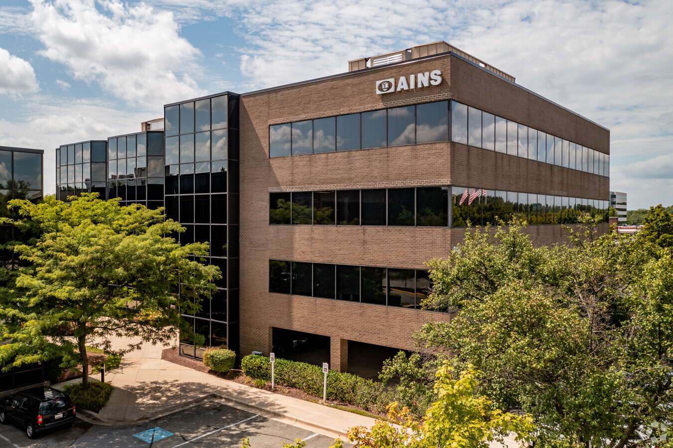
This Property Is For Sale
NEARBY LISTINGS FOR SALE OR LEASE
Property Detail
806 W Diamond Ave
09-03554406
Diamond Office Ctr A Prof Codm
Officecondo
UN 240 806 DIAMOND OFFICE CTR A PROF CODM AMENDED PLAT 9943
X
Montgomery
24031C0188D
Maryland
2024
44 SF
2024
Gaithersburg
700706
Washington, DC
1,115 SF
Washington-Arlington-Alexandria, DC-VA-MD-WV
DEMOGRAPHICS near 806 W Diamond Ave
1 Mile
3 Mile
5 Mile
2024 Total Population
15,497
153,378
303,469
2029 Population
15,373
151,891
299,742
Pop Growth 2024-2029
(0.80%)
(0.97%)
(1.23%)
Average Age
39
39
39
2024 Total Households
5,877
55,539
108,200
HH Growth 2024-2029
(0.80%)
(1.01%)
(1.32%)
Median Household Inc
$68,805
$95,704
$106,762
Avg Household Size
2.60
2.70
2.70
2024 Avg HH Vehicles
1.00
2.00
2.00
Median Home Value
$383,552
$426,862
$482,470
Median Year Built
1982
1985
1986
Nearby Places
- Restaurants
- Banks
- Shops
- Fitness
- Groceries
PUBLIC TRANSPORTATION
COMMUTER RAIL
Metropolitan Grove (Brunswick Line - Maryland Area Regional Commuter Trains (The MARC))
DRIVE
WALK
Distance
Metropolitan Grove (Brunswick Line - Maryland Area Regional Commuter Trains (The MARC))
4 min
1.2 mi
Gaithersburg (Brunswick Line - Maryland Area Regional Commuter Trains (The MARC))
DRIVE
WALK
Distance
Gaithersburg (Brunswick Line - Maryland Area Regional Commuter Trains (The MARC))
4 min
1.7 mi
AIRPORT
Ronald Reagan Washington Ntl
DRIVE
WALK
Distance
Ronald Reagan Washington Ntl
45 min
25.7 mi
Washington Dulles International
DRIVE
WALK
Distance
Washington Dulles International
50 min
32.0 mi
Baltimore/Washington International Thurgood Marshall
DRIVE
WALK
Distance
Baltimore/Washington International Thurgood Marshall
55 min
41.3 mi
Freight Ports
Port of Baltimore
DRIVE
WALK
Distance
Port of Baltimore
60 min
44.2 mi
Nearby Properties
Address
Land Use
TOTAL SIZE
Lot Size
Zoning
Address
Land Use
TOTAL SIZE
Lot Size
Zoning
849,305 SF
30.78 AC
MXD
Address
Land Use
TOTAL SIZE
Lot Size
Zoning
668,337 SF
10.39 AC
LSC1.
Address
Land Use
TOTAL SIZE
Lot Size
Zoning
290,912 SF
9.55 AC
LSC1.
Address
Land Use
TOTAL SIZE
Lot Size
Zoning
298,220 SF
38.37 AC
I3
Address
Land Use
TOTAL SIZE
Lot Size
Zoning
693,823 SF
5.30 AC
CR2.0
Address
Land Use
TOTAL SIZE
Lot Size
Zoning
754,379 SF
28.29 AC
R90
Address
Land Use
TOTAL SIZE
Lot Size
Zoning
431,178 SF
40.97 AC
RA
Address
Land Use
TOTAL SIZE
Lot Size
Zoning
298,300 SF
7.69 AC
CR1.0
Address
Land Use
TOTAL SIZE
Lot Size
Zoning
978,527 SF
11.54 AC
03
Address
Land Use
TOTAL SIZE
Lot Size
Zoning
185,000 SF
2.60 AC
EOF
Address
Land Use
TOTAL SIZE
Lot Size
Zoning
912,992 SF
6.11 AC
CBD
Address
Land Use
TOTAL SIZE
Lot Size
Zoning
315,000 SF
4.70 AC
CR1.5
Address
Land Use
TOTAL SIZE
Lot Size
Zoning
363,750 SF
21.16 AC
R60
Address
Land Use
TOTAL SIZE
Lot Size
Zoning
2,556 SF
555.47 AC
R200
Address
Land Use
TOTAL SIZE
Lot Size
Zoning
302,484 SF
4.99 AC
MXD
Address
Land Use
TOTAL SIZE
Lot Size
Zoning
370,422 SF
13.87 AC
CRT1.
Address
Land Use
TOTAL SIZE
Lot Size
Zoning
20.71 AC
MXD
Address
Land Use
TOTAL SIZE
Lot Size
Zoning
85,381 SF
5.86 AC
MXD
Address
Land Use
TOTAL SIZE
Lot Size
Zoning
373,116 SF
51.42 AC
I3
Address
Land Use
TOTAL SIZE
Lot Size
Zoning
899,156 SF
6.05 AC
CD
Address
Land Use
TOTAL SIZE
Lot Size
Zoning
325,990 SF
55.98 AC
CRT07
Address
Land Use
TOTAL SIZE
Lot Size
Zoning
17.64 AC
MXD
Address
Land Use
TOTAL SIZE
Lot Size
Zoning
240,000 SF
1.76 AC
MXD
Address
Land Use
TOTAL SIZE
Lot Size
Zoning
323,940 SF
17.92 AC
R30
Address
Land Use
TOTAL SIZE
Lot Size
Zoning
385,641 SF
2.65 AC
MXD
Address
Land Use
TOTAL SIZE
Lot Size
Zoning
170,689 SF
9.98 AC
LSC1.
Address
Land Use
TOTAL SIZE
Lot Size
Zoning
303,036 SF
5.10 AC
MXD
Address
Land Use
TOTAL SIZE
Lot Size
Zoning
565,209 SF
6.53 AC
MXD
Address
Land Use
TOTAL SIZE
Lot Size
Zoning
658,721 SF
4.90 AC
PD-UR
Address
Land Use
TOTAL SIZE
Lot Size
Zoning
279,442 SF
9.78 AC
CRT1.
The World's #1 Commercial Real Estate Marketplace
Connect with us
© 2025 CoStar Group
The information above has been obtained from sources believed reliable. While we do not doubt its accuracy we have not verified it and make no guarantee, warranty or representation about it. It is your responsibility to independently confirm its accuracy and completeness. Any projections, opinions, assumptions, or estimates used are for example only and do not represent the current or future performance of the property. The value of this transaction to you depends on tax and other factors which should be evaluated by your tax, financial, and legal advisors. You and your advisors should conduct a careful, independent investigation of the property to determine to your satisfaction the suitability of the property for your needs.