Property Record
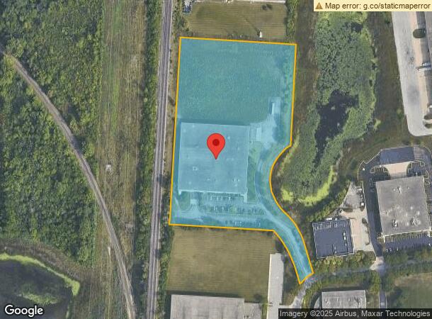
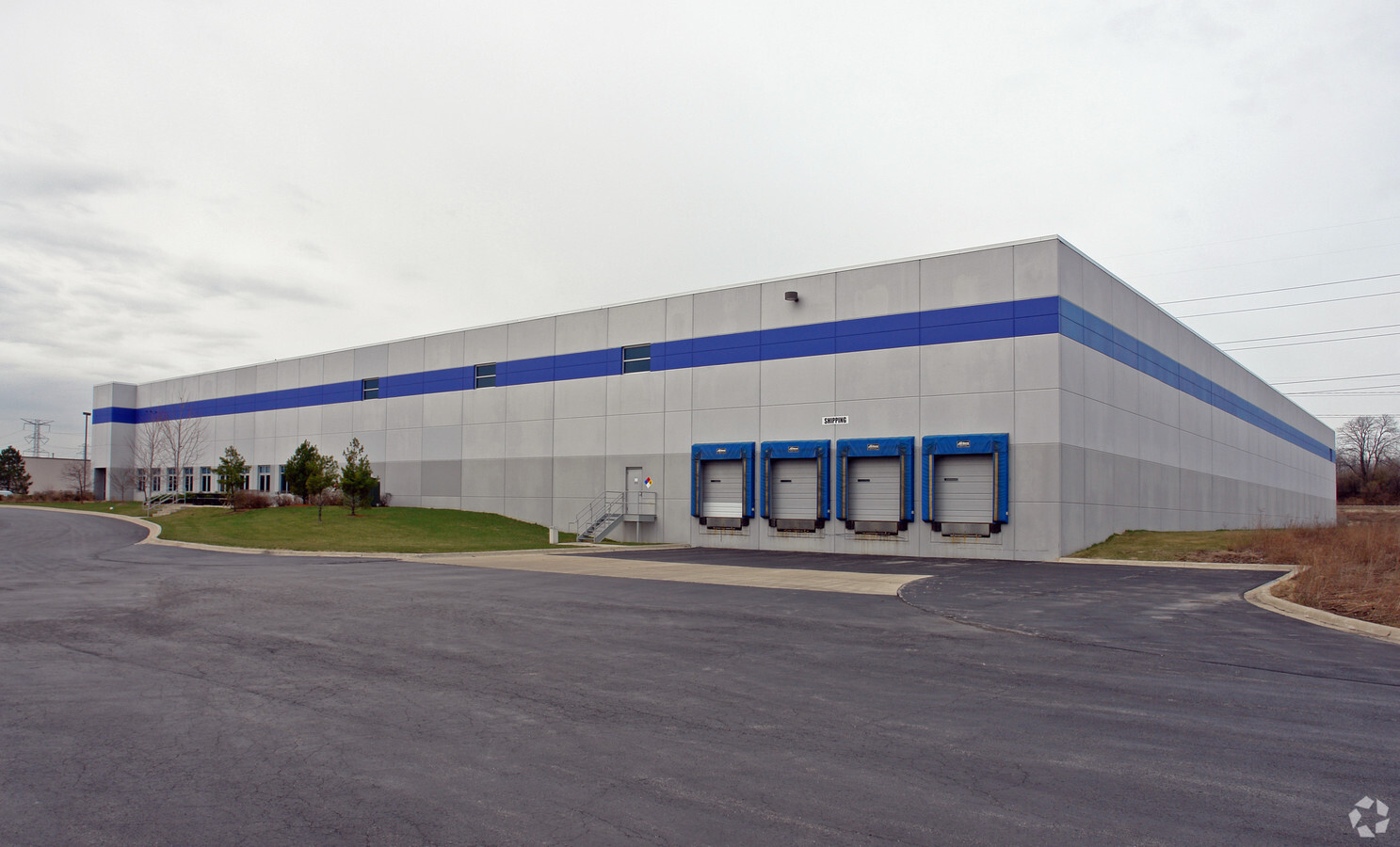
810 N Commerce St, Aurora, IL 60504


NEARBY LISTINGS FOR SALE OR LEASE
Property Detail
810 N Commerce St
Chicago-Naperville-Elgin, IL-IN-WI
Meridian Business Campus Phase 2 Unit 2
07-17-402-032
MERIDIAN BUSINESS CAMPUS PHASE 2 UNIT 2 ALL
Industrialgeneral
DuPage
X
Illinois
17043C0138J
5
2023
8.53 AC
2023
I-88 West
846507
Chicago
77,959 SF
DEMOGRAPHICS near 810 N Commerce St
1 Mile
3 Mile
5 Mile
2024 Total Population
8,026
88,971
245,212
2029 Population
7,951
88,125
243,223
Pop Growth 2024-2029
(0.93%)
(0.95%)
(0.81%)
Average Age
35
37
38
2024 Total Households
3,128
32,818
86,200
HH Growth 2024-2029
(1.15%)
(1.01%)
(0.82%)
Median Household Inc
$106,391
$104,261
$96,577
Avg Household Size
2.50
2.60
2.70
2024 Avg HH Vehicles
2.00
2.00
2.00
Median Home Value
$331,186
$320,828
$306,503
Median Year Built
1997
1992
1989
Nearby Places
- Restaurants
- Banks
- Shops
- Fitness
- Groceries
PUBLIC TRANSPORTATION
COMMUTER RAIL
Route 59 Station (Burlington Northern-Santa Fe Railway Line - Northeast Illinois Regional Commuter Railroad (Metra))
DRIVE
WALK
Distance
Route 59 Station (Burlington Northern-Santa Fe Railway Line - Northeast Illinois Regional Commuter Railroad (Metra))
8 min
3.0 mi
Aurora Station (Burlington Northern-Santa Fe Railway Line - Northeast Illinois Regional Commuter Railroad (Metra))
DRIVE
WALK
Distance
Aurora Station (Burlington Northern-Santa Fe Railway Line - Northeast Illinois Regional Commuter Railroad (Metra))
11 min
5.5 mi
AIRPORT
Chicago Midway International
DRIVE
WALK
Distance
Chicago Midway International
49 min
29.1 mi
Chicago O'Hare International
DRIVE
WALK
Distance
Chicago O'Hare International
50 min
33.0 mi
Freight Ports
Port Milwaukee
DRIVE
WALK
Distance
Port Milwaukee
131 min
104.7 mi
Nearby Properties
Address
Land Use
TOTAL SIZE
Lot Size
Zoning
Address
Land Use
TOTAL SIZE
Lot Size
Zoning
41.29 AC
Address
Land Use
TOTAL SIZE
Lot Size
Zoning
27.18 AC
Address
Land Use
TOTAL SIZE
Lot Size
Zoning
28.52 AC
R
Address
Land Use
TOTAL SIZE
Lot Size
Zoning
29.20 AC
C
Address
Land Use
TOTAL SIZE
Lot Size
Zoning
47.26 AC
Address
Land Use
TOTAL SIZE
Lot Size
Zoning
10.62 AC
Address
Land Use
TOTAL SIZE
Lot Size
Zoning
Address
Land Use
TOTAL SIZE
Lot Size
Zoning
31.66 AC
C
Address
Land Use
TOTAL SIZE
Lot Size
Zoning
19.92 AC
C
Address
Land Use
TOTAL SIZE
Lot Size
Zoning
17.70 AC
Address
Land Use
TOTAL SIZE
Lot Size
Zoning
683,677 SF
25.63 AC
Address
Land Use
TOTAL SIZE
Lot Size
Zoning
797,399 SF
52.38 AC
C
Address
Land Use
TOTAL SIZE
Lot Size
Zoning
20.97 AC
R
Address
Land Use
TOTAL SIZE
Lot Size
Zoning
829,087 SF
35.83 AC
C
Address
Land Use
TOTAL SIZE
Lot Size
Zoning
25 AC
M
Address
Land Use
TOTAL SIZE
Lot Size
Zoning
283,844 SF
16.06 AC
M
Address
Land Use
TOTAL SIZE
Lot Size
Zoning
17.84 AC
M
Address
Land Use
TOTAL SIZE
Lot Size
Zoning
16.15 AC
M
Address
Land Use
TOTAL SIZE
Lot Size
Zoning
15.61 AC
M
Address
Land Use
TOTAL SIZE
Lot Size
Zoning
27.67 AC
Address
Land Use
TOTAL SIZE
Lot Size
Zoning
649,717 SF
27.79 AC
I
Address
Land Use
TOTAL SIZE
Lot Size
Zoning
11.02 AC
M
Address
Land Use
TOTAL SIZE
Lot Size
Zoning
594,880 SF
29.15 AC
I
Address
Land Use
TOTAL SIZE
Lot Size
Zoning
16.86 AC
C
Address
Land Use
TOTAL SIZE
Lot Size
Zoning
12.70 AC
Address
Land Use
TOTAL SIZE
Lot Size
Zoning
286,400 SF
9.50 AC
Address
Land Use
TOTAL SIZE
Lot Size
Zoning
522,457 SF
29.33 AC
I
Address
Land Use
TOTAL SIZE
Lot Size
Zoning
9.83 AC
C
Address
Land Use
TOTAL SIZE
Lot Size
Zoning
707,333 SF
63.75 AC
Address
Land Use
TOTAL SIZE
Lot Size
Zoning
479,470 SF
24.67 AC
I
The World's #1 Commercial Real Estate Marketplace
Connect with us
© 2025 CoStar Group
The information above has been obtained from sources believed reliable. While we do not doubt its accuracy we have not verified it and make no guarantee, warranty or representation about it. It is your responsibility to independently confirm its accuracy and completeness. Any projections, opinions, assumptions, or estimates used are for example only and do not represent the current or future performance of the property. The value of this transaction to you depends on tax and other factors which should be evaluated by your tax, financial, and legal advisors. You and your advisors should conduct a careful, independent investigation of the property to determine to your satisfaction the suitability of the property for your needs.