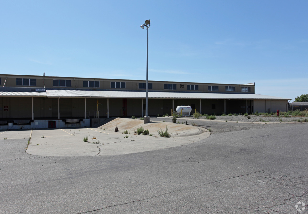
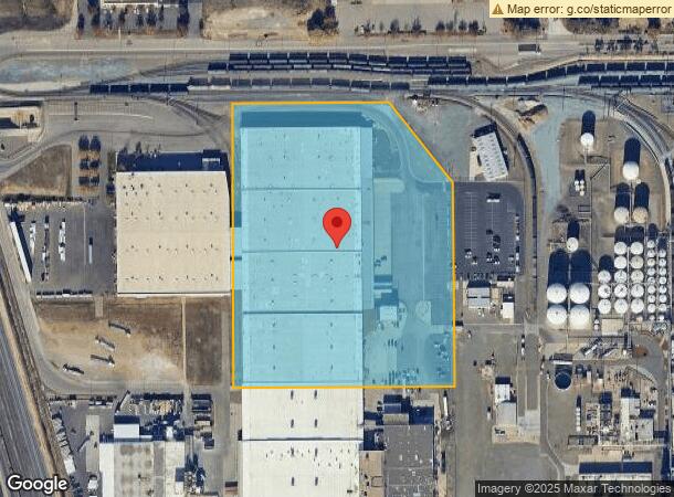
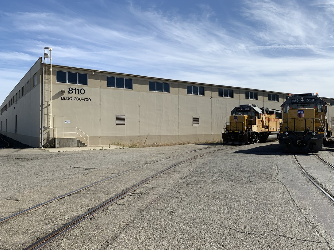
Property Record
8110 Power Ridge Rd, Sacramento, CA 95826

Current Lease Availabilities
NEARBY LISTINGS FOR SALE OR LEASE
Property Detail
8110 Power Ridge Rd
Sacramento--Roseville--Arden-Arcade, CA
Parcel Map Of Huttig
061-0010-048
PARCEL MAP OF HUTTIG, LOT 2
Shipyard
Sacramento
X
California
06067C0195H
2
2023
10.15 AC
2024
Power Inn
005205
Sacramento
236,538 SF
DEMOGRAPHICS near 8110 Power Ridge Rd
1 Mile
3 Mile
5 Mile
2024 Total Population
8,434
128,783
381,077
2029 Population
8,468
129,740
383,975
Pop Growth 2024-2029
+ 0.40%
+ 0.74%
+ 0.76%
Average Age
37
37
38
2024 Total Households
2,594
44,978
137,618
HH Growth 2024-2029
+ 0.35%
+ 0.79%
+ 0.80%
Median Household Inc
$57,065
$61,659
$68,023
Avg Household Size
3.10
2.70
2.60
2024 Avg HH Vehicles
2.00
2.00
2.00
Median Home Value
$317,588
$381,422
$418,969
Median Year Built
1964
1970
1971
Nearby Places
- Restaurants
- Banks
- Shops
- Fitness
- Groceries
PUBLIC TRANSPORTATION
AIRPORT
Sacramento International
DRIVE
WALK
Distance
Sacramento International
30 min
20.1 mi
Freight Ports
Port of Stockton
DRIVE
WALK
Distance
Port of Stockton
61 min
48.3 mi
Nearby Properties
Address
Land Use
TOTAL SIZE
Lot Size
Zoning
Address
Land Use
TOTAL SIZE
Lot Size
Zoning
2,317,288 SF
220.58 AC
M-2-SPD
Address
Land Use
TOTAL SIZE
Lot Size
Zoning
9.29 AC
R-1 OB-R-P
Address
Land Use
TOTAL SIZE
Lot Size
Zoning
350,049 SF
8.51 AC
MRD-SWR
Address
Land Use
TOTAL SIZE
Lot Size
Zoning
45.93 AC
M-2S
Address
Land Use
TOTAL SIZE
Lot Size
Zoning
149,566 SF
9.68 AC
M-2S
Address
Land Use
TOTAL SIZE
Lot Size
Zoning
281,448 SF
13.42 AC
RMX-TO R-2
Address
Land Use
TOTAL SIZE
Lot Size
Zoning
40.67 AC
M-2-SPD
Address
Land Use
TOTAL SIZE
Lot Size
Zoning
187,080 SF
10.01 AC
SPA
Address
Land Use
TOTAL SIZE
Lot Size
Zoning
119,380 SF
18.92 AC
M-2S
Address
Land Use
TOTAL SIZE
Lot Size
Zoning
156,462 SF
8.36 AC
R-3
Address
Land Use
TOTAL SIZE
Lot Size
Zoning
198,131 SF
13.36 AC
BP
Address
Land Use
TOTAL SIZE
Lot Size
Zoning
584,820 SF
29.12 AC
M-2S
Address
Land Use
TOTAL SIZE
Lot Size
Zoning
345,600 SF
14.84 AC
M-1S-SWR
Address
Land Use
TOTAL SIZE
Lot Size
Zoning
164,981 SF
3.95 AC
OB-SWR-PUD
Address
Land Use
TOTAL SIZE
Lot Size
Zoning
171,405 SF
13.80 AC
R-1
Address
Land Use
TOTAL SIZE
Lot Size
Zoning
192,308 SF
5.42 AC
C-2
Address
Land Use
TOTAL SIZE
Lot Size
Zoning
303,950 SF
19.34 AC
R-2A-R
Address
Land Use
TOTAL SIZE
Lot Size
Zoning
0.12 AC
SPA
Address
Land Use
TOTAL SIZE
Lot Size
Zoning
128,950 SF
0.75 AC
RMX-TO-SPD
Address
Land Use
TOTAL SIZE
Lot Size
Zoning
261,350 SF
14.41 AC
M-2S
Address
Land Use
TOTAL SIZE
Lot Size
Zoning
168,846 SF
7.58 AC
RD-30 (PC)
Address
Land Use
TOTAL SIZE
Lot Size
Zoning
146,643 SF
4.55 AC
RMX-TO-SPD
Address
Land Use
TOTAL SIZE
Lot Size
Zoning
119,824 SF
7.64 AC
RD-30 (PC)
Address
Land Use
TOTAL SIZE
Lot Size
Zoning
159,121 SF
10.38 AC
C-2-TO
Address
Land Use
TOTAL SIZE
Lot Size
Zoning
213,445 SF
18.25 AC
SC
Address
Land Use
TOTAL SIZE
Lot Size
Zoning
135,375 SF
7.40 AC
RD-30
Address
Land Use
TOTAL SIZE
Lot Size
Zoning
158,710 SF
14.02 AC
M-1
Address
Land Use
TOTAL SIZE
Lot Size
Zoning
271,016 SF
15.54 AC
R-2B-PUD
Address
Land Use
TOTAL SIZE
Lot Size
Zoning
87,402 SF
3.94 AC
R-3
Address
Land Use
TOTAL SIZE
Lot Size
Zoning
138,779 SF
44.77 AC
M-2S
The World's #1 Commercial Real Estate Marketplace
Connect with us
© 2025 CoStar Group
The information above has been obtained from sources believed reliable. While we do not doubt its accuracy we have not verified it and make no guarantee, warranty or representation about it. It is your responsibility to independently confirm its accuracy and completeness. Any projections, opinions, assumptions, or estimates used are for example only and do not represent the current or future performance of the property. The value of this transaction to you depends on tax and other factors which should be evaluated by your tax, financial, and legal advisors. You and your advisors should conduct a careful, independent investigation of the property to determine to your satisfaction the suitability of the property for your needs.