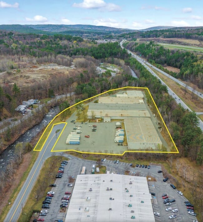
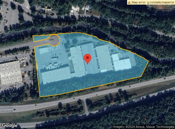
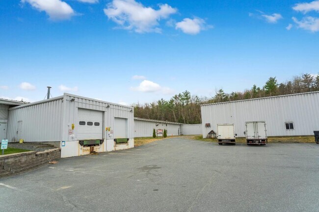
Property Record
82 Benning St, West Lebanon, NH 03784
NEARBY LISTINGS FOR SALE OR LEASE
Property Detail
82 Benning St
Manufacturinglight
Grafton
AE
New Hampshire
33009C0893E
10.19 AC
2024
Concord/New Hampshire North Area
2024
Other Market Areas
961702
Claremont-Lebanon, NH-VT
163,990 SF
115-13
DEMOGRAPHICS near 82 Benning St
1 Mile
3 Mile
5 Mile
2024 Total Population
1,977
11,503
26,816
2029 Population
2,052
11,808
27,794
Pop Growth 2024-2029
+ 3.79%
+ 2.65%
+ 3.65%
Average Age
44
43
41
2024 Total Households
952
5,374
12,009
HH Growth 2024-2029
+ 3.68%
+ 2.49%
+ 3.69%
Median Household Inc
$70,095
$73,802
$85,328
Avg Household Size
2.00
2.10
2.10
2024 Avg HH Vehicles
2.00
2.00
2.00
Median Home Value
$280,223
$264,395
$294,888
Median Year Built
1976
1973
1979
Nearby Places
Map Layers
Map Styles
 Street
 Aerial
- Restaurants
- Banks
- Shops
- Fitness
- Groceries
PUBLIC TRANSPORTATION
COMMUTER RAIL
DRIVE
WALK
Distance
8 min
2.5 mi
SALE & LEASE HISTORY
LISTING DATE
SALE/LEASE

Sep 25, 2016
For Lease
Oct 17, 2024
For Sale
Jun 01, 2023
For Sale
Feb 05, 2018
For Lease
Aug 12, 2022
For Lease
Nearby Properties
Address
Land Use
TOTAL SIZE
Lot Size
Zoning
Address
Land Use
TOTAL SIZE
Lot Size
Zoning
447.50 AC
INDL
Address
Land Use
TOTAL SIZE
Lot Size
Zoning
29.80 AC
GC
Address
Land Use
TOTAL SIZE
Lot Size
Zoning
3.76 AC
GC
Address
Land Use
TOTAL SIZE
Lot Size
Zoning
1,315 SF
16.35 AC
RL3
Address
Land Use
TOTAL SIZE
Lot Size
Zoning
86.78 AC
IC
Address
Land Use
TOTAL SIZE
Lot Size
Zoning
14.11 AC
INDL
Address
Land Use
TOTAL SIZE
Lot Size
Zoning
18.38 AC
R3
Address
Land Use
TOTAL SIZE
Lot Size
Zoning
22.14 AC
GC
Address
Land Use
TOTAL SIZE
Lot Size
Zoning
10.20 AC
R3
Address
Land Use
TOTAL SIZE
Lot Size
Zoning
Address
Land Use
TOTAL SIZE
Lot Size
Zoning
23.33 AC
R3
Address
Land Use
TOTAL SIZE
Lot Size
Zoning
22.88 AC
GC
Address
Land Use
TOTAL SIZE
Lot Size
Zoning
36.71 AC
GC
Address
Land Use
TOTAL SIZE
Lot Size
Zoning
20.61 AC
GC
Address
Land Use
TOTAL SIZE
Lot Size
Zoning
80,493 SF
7.39 AC
GC
Address
Land Use
TOTAL SIZE
Lot Size
Zoning
7.89 AC
GC
Address
Land Use
TOTAL SIZE
Lot Size
Zoning
Address
Land Use
TOTAL SIZE
Lot Size
Zoning
26.70 AC
INDL
Address
Land Use
TOTAL SIZE
Lot Size
Zoning
7.63 AC
GC
Address
Land Use
TOTAL SIZE
Lot Size
Zoning
54.48 AC
R3
Address
Land Use
TOTAL SIZE
Lot Size
Zoning
11.23 AC
GC
Address
Land Use
TOTAL SIZE
Lot Size
Zoning
15.60 AC
GC
Address
Land Use
TOTAL SIZE
Lot Size
Zoning
44,695 SF
35.80 AC
HC
Address
Land Use
TOTAL SIZE
Lot Size
Zoning
323.53 AC
INDH
Address
Land Use
TOTAL SIZE
Lot Size
Zoning
Address
Land Use
TOTAL SIZE
Lot Size
Zoning
99.80 AC
INDH
Address
Land Use
TOTAL SIZE
Lot Size
Zoning
0.87 AC
CB
Address
Land Use
TOTAL SIZE
Lot Size
Zoning
7.28 AC
GC
Address
Land Use
TOTAL SIZE
Lot Size
Zoning
102,489 SF
GC
The World's #1 Commercial Real Estate Marketplace
Connect with us
© 2025 CoStar Group
The information above has been obtained from sources believed reliable. While we do not doubt its accuracy we have not verified it and make no guarantee, warranty or representation about it. It is your responsibility to independently confirm its accuracy and completeness. Any projections, opinions, assumptions, or estimates used are for example only and do not represent the current or future performance of the property. The value of this transaction to you depends on tax and other factors which should be evaluated by your tax, financial, and legal advisors. You and your advisors should conduct a careful, independent investigation of the property to determine to your satisfaction the suitability of the property for your needs.