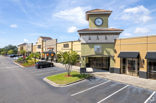
Property Record
8206 Philips Hwy, Jacksonville, FL 32256

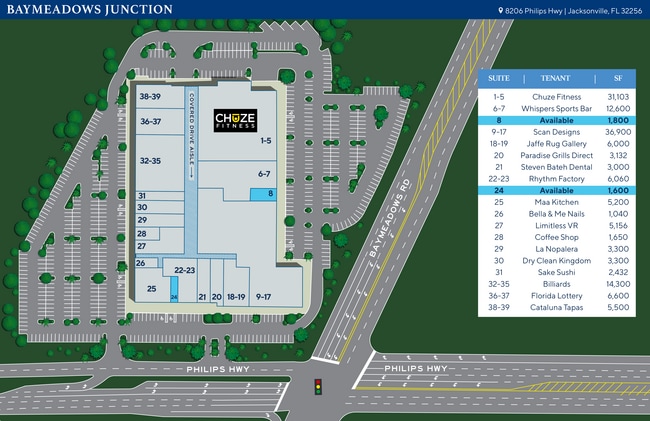
Current Lease Availabilities
NEARBY LISTINGS FOR SALE OR LEASE
Property Detail
8206 Philips Hwy
Jacksonville, FL
Section Land
152664-0000
56-3S-27E 12.840 PT F RICHARD GRANT,PT GOVT LOT 1 SEC 27 RECD O/R 11065-150
Regionalshoppingcenterormallwithanchorstore
Duval
X
Florida
12031C0552H
1
2025
12.84 AC
2026
Mandarin
016725
Jacksonville (Florida)
184,663 SF
DEMOGRAPHICS near 8206 Philips Hwy
1 Mile
3 Mile
5 Mile
2024 Total Population
6,793
85,212
184,758
2029 Population
7,198
89,820
193,814
Pop Growth 2024-2029
+ 5.96%
+ 5.41%
+ 4.90%
Average Age
39
39
40
2024 Total Households
2,759
37,767
80,250
HH Growth 2024-2029
+ 5.94%
+ 5.65%
+ 5.06%
Median Household Inc
$63,735
$62,369
$67,010
Avg Household Size
2.40
2.20
2.20
2024 Avg HH Vehicles
2.00
2.00
2.00
Median Home Value
$275,718
$265,207
$271,080
Median Year Built
1986
1987
1989
Nearby Places
Map Layers
Map Styles
 Street
 Aerial
- Restaurants
- Banks
- Shops
- Fitness
- Groceries
PUBLIC TRANSPORTATION
AIRPORT
Jacksonville International
DRIVE
WALK
Distance
Jacksonville International
39 min
25.7 mi
Nearby Properties
Address
Land Use
TOTAL SIZE
Lot Size
Zoning
Address
Land Use
TOTAL SIZE
Lot Size
Zoning
1,159,855 SF
89.44 AC
RMD-D
Address
Land Use
TOTAL SIZE
Lot Size
Zoning
1,013,318 SF
131.30 AC
PUD
Address
Land Use
TOTAL SIZE
Lot Size
Zoning
251,691 SF
17.51 AC
PUD
Address
Land Use
TOTAL SIZE
Lot Size
Zoning
478,012 SF
29.87 AC
PUD
Address
Land Use
TOTAL SIZE
Lot Size
Zoning
419,299 SF
40.24 AC
PUD
Address
Land Use
TOTAL SIZE
Lot Size
Zoning
723,629 SF
18.30 AC
PUD
Address
Land Use
TOTAL SIZE
Lot Size
Zoning
371,466 SF
49.16 AC
PBF-2
Address
Land Use
TOTAL SIZE
Lot Size
Zoning
223,939 SF
13.28 AC
PUD
Address
Land Use
TOTAL SIZE
Lot Size
Zoning
209,436 SF
14.38 AC
PUD
Address
Land Use
TOTAL SIZE
Lot Size
Zoning
954,167 SF
56.79 AC
PUD
Address
Land Use
TOTAL SIZE
Lot Size
Zoning
273,196 SF
16.57 AC
PUD
Address
Land Use
TOTAL SIZE
Lot Size
Zoning
341,849 SF
15 AC
PUD
Address
Land Use
TOTAL SIZE
Lot Size
Zoning
217,557 SF
14.72 AC
PUD
Address
Land Use
TOTAL SIZE
Lot Size
Zoning
446,326 SF
23.68 AC
RMD-D
Address
Land Use
TOTAL SIZE
Lot Size
Zoning
383,228 SF
40.69 AC
PUD
Address
Land Use
TOTAL SIZE
Lot Size
Zoning
464,189 SF
44.85 AC
RMD-D
Address
Land Use
TOTAL SIZE
Lot Size
Zoning
316,705 SF
15.44 AC
PUD
Address
Land Use
TOTAL SIZE
Lot Size
Zoning
249,222 SF
42.67 AC
PUD
Address
Land Use
TOTAL SIZE
Lot Size
Zoning
281,793 SF
17.43 AC
PUD
Address
Land Use
TOTAL SIZE
Lot Size
Zoning
358,537 SF
29.16 AC
RMD-C
Address
Land Use
TOTAL SIZE
Lot Size
Zoning
367,197 SF
42.36 AC
RMD-B
Address
Land Use
TOTAL SIZE
Lot Size
Zoning
193,941 SF
7.35 AC
PUD
Address
Land Use
TOTAL SIZE
Lot Size
Zoning
569,816 SF
17.76 AC
PUD
Address
Land Use
TOTAL SIZE
Lot Size
Zoning
365,629 SF
23.23 AC
RMD-D
Address
Land Use
TOTAL SIZE
Lot Size
Zoning
273,616 SF
34.49 AC
RMD-B
Address
Land Use
TOTAL SIZE
Lot Size
Zoning
307,396 SF
24.45 AC
PUD
Address
Land Use
TOTAL SIZE
Lot Size
Zoning
348,919 SF
18.08 AC
RMD-D
Address
Land Use
TOTAL SIZE
Lot Size
Zoning
330,037 SF
28.33 AC
RMD-C
Address
Land Use
TOTAL SIZE
Lot Size
Zoning
325,848 SF
25.78 AC
RMD-C
Address
Land Use
TOTAL SIZE
Lot Size
Zoning
313,009 SF
22.50 AC
RMD-D
The World's #1 Commercial Real Estate Marketplace
Connect with us
© 2025 CoStar Group
The information above has been obtained from sources believed reliable. While we do not doubt its accuracy we have not verified it and make no guarantee, warranty or representation about it. It is your responsibility to independently confirm its accuracy and completeness. Any projections, opinions, assumptions, or estimates used are for example only and do not represent the current or future performance of the property. The value of this transaction to you depends on tax and other factors which should be evaluated by your tax, financial, and legal advisors. You and your advisors should conduct a careful, independent investigation of the property to determine to your satisfaction the suitability of the property for your needs.