No Photo
Property Record
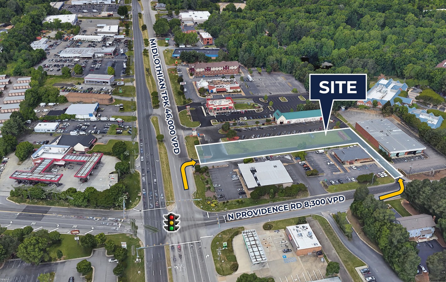
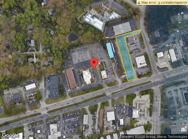
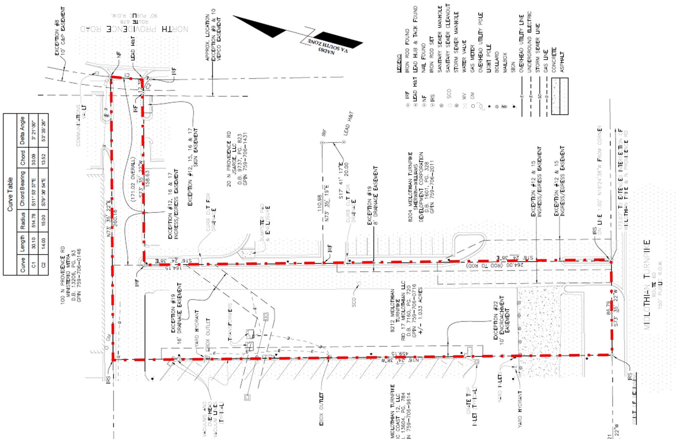
8212 Midlothian Tpke, North Chesterfield, VA 23235
Current Lease Availabilities
NEARBY LISTINGS FOR SALE OR LEASE
Property Detail
8212 Midlothian Tpke
Richmond, VA
N/L Midlothian Turnpike Par B
759-70-60-71-600-000
N/L MIDLOTHIAN TURNPIKE PAR B
Commercialnec
Chesterfield
X
Virginia
51041C0131E
b
2024
1.03 AC
2024
Midlothian Corridor
100907
Richmond VA
DEMOGRAPHICS near 8212 Midlothian Tpke
1 Mile
3 Mile
5 Mile
2024 Total Population
6,784
67,620
174,720
2029 Population
7,397
72,116
185,504
Pop Growth 2024-2029
+ 9.04%
+ 6.65%
+ 6.17%
Average Age
42
40
41
2024 Total Households
2,820
27,560
70,240
HH Growth 2024-2029
+ 9.36%
+ 6.51%
+ 6.03%
Median Household Inc
$57,999
$63,943
$69,686
Avg Household Size
2.30
2.40
2.40
2024 Avg HH Vehicles
2.00
2.00
2.00
Median Home Value
$244,619
$254,866
$276,929
Median Year Built
1981
1978
1978
Nearby Places
- Restaurants
- Banks
- Shops
- Fitness
- Groceries
PUBLIC TRANSPORTATION
COMMUTER RAIL
Richmond Main Street Amtrak Station (Northeast Regional - Amtrak)
DRIVE
WALK
Distance
Richmond Main Street Amtrak Station (Northeast Regional - Amtrak)
16 min
9.9 mi
AIRPORT
Richmond International
DRIVE
WALK
Distance
Richmond International
30 min
20.2 mi
Freight Ports
Virginia Port Authority - Richmond
DRIVE
WALK
Distance
Virginia Port Authority - Richmond
19 min
9.1 mi
Nearby Properties
Address
Land Use
TOTAL SIZE
Lot Size
Zoning
Address
Land Use
TOTAL SIZE
Lot Size
Zoning
281,961 SF
32.19 AC
R-73 MULTI
Address
Land Use
TOTAL SIZE
Lot Size
Zoning
98,112 SF
71.88 AC
MULTIPLE Z
Address
Land Use
TOTAL SIZE
Lot Size
Zoning
46,620 SF
12.78 AC
C4 - REGIO
Address
Land Use
TOTAL SIZE
Lot Size
Zoning
196,592 SF
30.85 AC
R-48 MULTI
Address
Land Use
TOTAL SIZE
Lot Size
Zoning
176,896 SF
28.35 AC
A - AGRICU
Address
Land Use
TOTAL SIZE
Lot Size
Zoning
13,781 SF
24.53 AC
RMF - RES,
Address
Land Use
TOTAL SIZE
Lot Size
Zoning
209,804 SF
9.43 AC
C3 - COMMU
Address
Land Use
TOTAL SIZE
Lot Size
Zoning
104,589 SF
32.12 AC
R7 - SINGL
Address
Land Use
TOTAL SIZE
Lot Size
Zoning
199,310 SF
1.15 AC
LAC2
Address
Land Use
TOTAL SIZE
Lot Size
Zoning
155,353 SF
26.01 AC
R-2 SINGLE
Address
Land Use
TOTAL SIZE
Lot Size
Zoning
235,098 SF
37.52 AC
R-2 SINGLE
Address
Land Use
TOTAL SIZE
Lot Size
Zoning
41,805 SF
26.90 AC
O2 - CORP
Address
Land Use
TOTAL SIZE
Lot Size
Zoning
77,657 SF
27.17 AC
R7 - SINGL
Address
Land Use
TOTAL SIZE
Lot Size
Zoning
292,968 SF
24.03 AC
MULTIPLE Z
Address
Land Use
TOTAL SIZE
Lot Size
Zoning
183,759 SF
19.59 AC
R-3 SINGLE
Address
Land Use
TOTAL SIZE
Lot Size
Zoning
194,463 SF
27.32 AC
R-3 SINGLE
Address
Land Use
TOTAL SIZE
Lot Size
Zoning
280,360 SF
4.03 AC
C4 - REGIO
Address
Land Use
TOTAL SIZE
Lot Size
Zoning
106,256 SF
18.66 AC
R7 - SINGL
Address
Land Use
TOTAL SIZE
Lot Size
Zoning
261,000 SF
10.36 AC
RMF - RES,
Address
Land Use
TOTAL SIZE
Lot Size
Zoning
7,630 SF
63.16 AC
A - AGRICU
Address
Land Use
TOTAL SIZE
Lot Size
Zoning
3,713 SF
24.57 AC
R-43 MULTI
Address
Land Use
TOTAL SIZE
Lot Size
Zoning
110,320 SF
13.06 AC
R-43 MULTI
Address
Land Use
TOTAL SIZE
Lot Size
Zoning
20,078 SF
100 AC
A - AGRICU
Address
Land Use
TOTAL SIZE
Lot Size
Zoning
224,780 SF
12.27 AC
B-3 GENERA
Address
Land Use
TOTAL SIZE
Lot Size
Zoning
100 SF
23.61 AC
R7 - SINGL
Address
Land Use
TOTAL SIZE
Lot Size
Zoning
95,944 SF
14.76 AC
A - AGRICU
Address
Land Use
TOTAL SIZE
Lot Size
Zoning
12 AC
MULTIPLE Z
Address
Land Use
TOTAL SIZE
Lot Size
Zoning
36,237 SF
16.67 AC
C3 - COMMU
Address
Land Use
TOTAL SIZE
Lot Size
Zoning
100 SF
18.04 AC
R7 - SINGL
Address
Land Use
TOTAL SIZE
Lot Size
Zoning
93,846 SF
11.91 AC
R15 - SING
The World's #1 Commercial Real Estate Marketplace
Connect with us
© 2025 CoStar Group
The information above has been obtained from sources believed reliable. While we do not doubt its accuracy we have not verified it and make no guarantee, warranty or representation about it. It is your responsibility to independently confirm its accuracy and completeness. Any projections, opinions, assumptions, or estimates used are for example only and do not represent the current or future performance of the property. The value of this transaction to you depends on tax and other factors which should be evaluated by your tax, financial, and legal advisors. You and your advisors should conduct a careful, independent investigation of the property to determine to your satisfaction the suitability of the property for your needs.