Property Record
822 Central Ave, Linthicum Heights, MD 21090


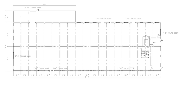
Current Lease Availabilities
Property Detail
822 Central Ave
05-000-08988700
3.094 ACRES NR RAYNOR HGTS
Officebuilding
Anne Arundel
W2
Maryland
B and X Area of moderate flood hazard, usually the area between the limits of the 100-year and 500-year floods.
3.09 AC
2024
BWI North/Linthicum
2025
Baltimore
750300
Baltimore-Columbia-Towson, MD
33,850 SF
NEARBY LISTINGS FOR SALE OR LEASE
DEMOGRAPHICS near 822 Central Ave
1 mile
3 mile
5 mile
2025 Total Population
9,375
93,556
251,021
2030 Population
9,420
93,302
251,711
Pop Growth 2025-2030
+ 0.48%
(0.27%)
+ 0.27%
Average Age
37
38
38
2025 Total Households
3,291
34,210
99,349
HH Growth 2025-2030
+ 0.52%
(0.28%)
+ 0.09%
Median Household Inc
$75,468
$75,445
$72,354
Avg Household Size
2.80
2.60
2.40
2025 Avg HH Vehicles
2.00
2.00
1.00
Median Home Value
$266,419
$286,746
$290,979
Median Year Built
1958
1957
1956
Nearby Places
Map Layers
Map Styles
 Street
 Aerial
Layers
 Traffic
 Biking
Places
Listings with unknown addresses are not visible on the map
- Restaurants
- Banks
- Shops
- Fitness
- Groceries
PUBLIC TRANSPORTATION
TRANSIT/SUBWAY
Nursery Road (Hunt Valley & BWI Marshall - Maryland Transit Administration Light Rail (Baltimore Light Rail), Timonium & Cromwell - Maryland Transit Administration Light Rail (Baltimore Light Rail))
Drive
Walk
Distance
Nursery Road (Hunt Valley & BWI Marshall - Maryland Transit Administration Light Rail (Baltimore Light Rail), Timonium & Cromwell - Maryland Transit Administration Light Rail (Baltimore Light Rail))
3 min
20 min
1.0 mi
COMMUTER RAIL
Drive
Walk
Distance
9 min
3.8 mi
Drive
Walk
Distance
9 min
3.8 mi
AIRPORT
Baltimore/Washington International Thurgood Marshall
Drive
Walk
Distance
Baltimore/Washington International Thurgood Marshall
11 min
5.0 mi
Ronald Reagan Washington Ntl
Drive
Walk
Distance
Ronald Reagan Washington Ntl
58 min
37.4 mi
Freight Ports
Port of Baltimore
Drive
Walk
Distance
Port of Baltimore
14 min
7.7 mi
Nearby Properties
Address
Land Use
TOTAL SIZE
Lot Size
Zoning
Address
Land Use
TOTAL SIZE
Lot Size
Zoning
430,940 SF
18.81 AC
MXDT
Address
Land Use
TOTAL SIZE
Lot Size
Zoning
520,407 SF
16.85 AC
H
Address
Land Use
TOTAL SIZE
Lot Size
Zoning
305,483 SF
11.38 AC
MXDT
Address
Land Use
TOTAL SIZE
Lot Size
Zoning
332,190 SF
21.80 AC
W1-BW
Address
Land Use
TOTAL SIZE
Lot Size
Zoning
454,684 SF
6.88 AC
W1B
Address
Land Use
TOTAL SIZE
Lot Size
Zoning
383,697 SF
68.35 AC
R5
Address
Land Use
TOTAL SIZE
Lot Size
Zoning
315,055 SF
9.60 AC
ML
Address
Land Use
TOTAL SIZE
Lot Size
Zoning
292,269 SF
15.86 AC
W1-BW
Address
Land Use
TOTAL SIZE
Lot Size
Zoning
231,128 SF
8.30 AC
W1-BW
Address
Land Use
TOTAL SIZE
Lot Size
Zoning
19.20 AC
R15
Address
Land Use
TOTAL SIZE
Lot Size
Zoning
1,555.10 AC
R1
Address
Land Use
TOTAL SIZE
Lot Size
Zoning
12.90 AC
R15
Address
Land Use
TOTAL SIZE
Lot Size
Zoning
263,024 SF
6.87 AC
C3
Address
Land Use
TOTAL SIZE
Lot Size
Zoning
18.86 AC
DR16
Address
Land Use
TOTAL SIZE
Lot Size
Zoning
184,317 SF
16.23 AC
MH
Address
Land Use
TOTAL SIZE
Lot Size
Zoning
41.14 AC
W1-BW
Address
Land Use
TOTAL SIZE
Lot Size
Zoning
300,513 SF
32.53 AC
I-1
Address
Land Use
TOTAL SIZE
Lot Size
Zoning
16.26 AC
R15
Address
Land Use
TOTAL SIZE
Lot Size
Zoning
15.05 AC
R15
Address
Land Use
TOTAL SIZE
Lot Size
Zoning
187,814 SF
38.47 AC
R5
Address
Land Use
TOTAL SIZE
Lot Size
Zoning
48,300 SF
30.96 AC
ML
Address
Land Use
TOTAL SIZE
Lot Size
Zoning
116,600 SF
8.97 AC
C4
Address
Land Use
TOTAL SIZE
Lot Size
Zoning
101,220 SF
17.51 AC
DR5.5
Address
Land Use
TOTAL SIZE
Lot Size
Zoning
338,255 SF
42.87 AC
W1-BW
Address
Land Use
TOTAL SIZE
Lot Size
Zoning
204,000 SF
7.70 AC
W1-BW
Address
Land Use
TOTAL SIZE
Lot Size
Zoning
194,652 SF
20.49 AC
W1-BW
Address
Land Use
TOTAL SIZE
Lot Size
Zoning
19.86 AC
DR16
Address
Land Use
TOTAL SIZE
Lot Size
Zoning
145,226 SF
9.24 AC
W1
Address
Land Use
TOTAL SIZE
Lot Size
Zoning
21.46 AC
ML
Address
Land Use
TOTAL SIZE
Lot Size
Zoning
86,587 SF
9.86 AC
W1-BW
The World's #1 Commercial Real Estate Marketplace
Connect with us
© 2026 CoStar Group
The information above has been obtained from sources believed reliable. While we do not doubt its accuracy we have not verified it and make no guarantee, warranty or representation about it. It is your responsibility to independently confirm its accuracy and completeness. Any projections, opinions, assumptions, or estimates used are for example only and do not represent the current or future performance of the property. The value of this transaction to you depends on tax and other factors which should be evaluated by your tax, financial, and legal advisors. You and your advisors should conduct a careful, independent investigation of the property to determine to your satisfaction the suitability of the property for your needs.