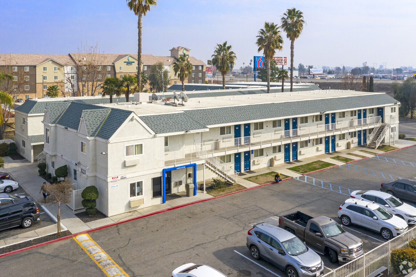
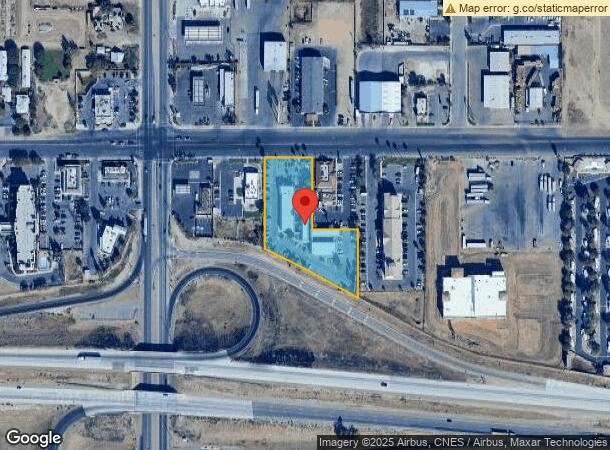
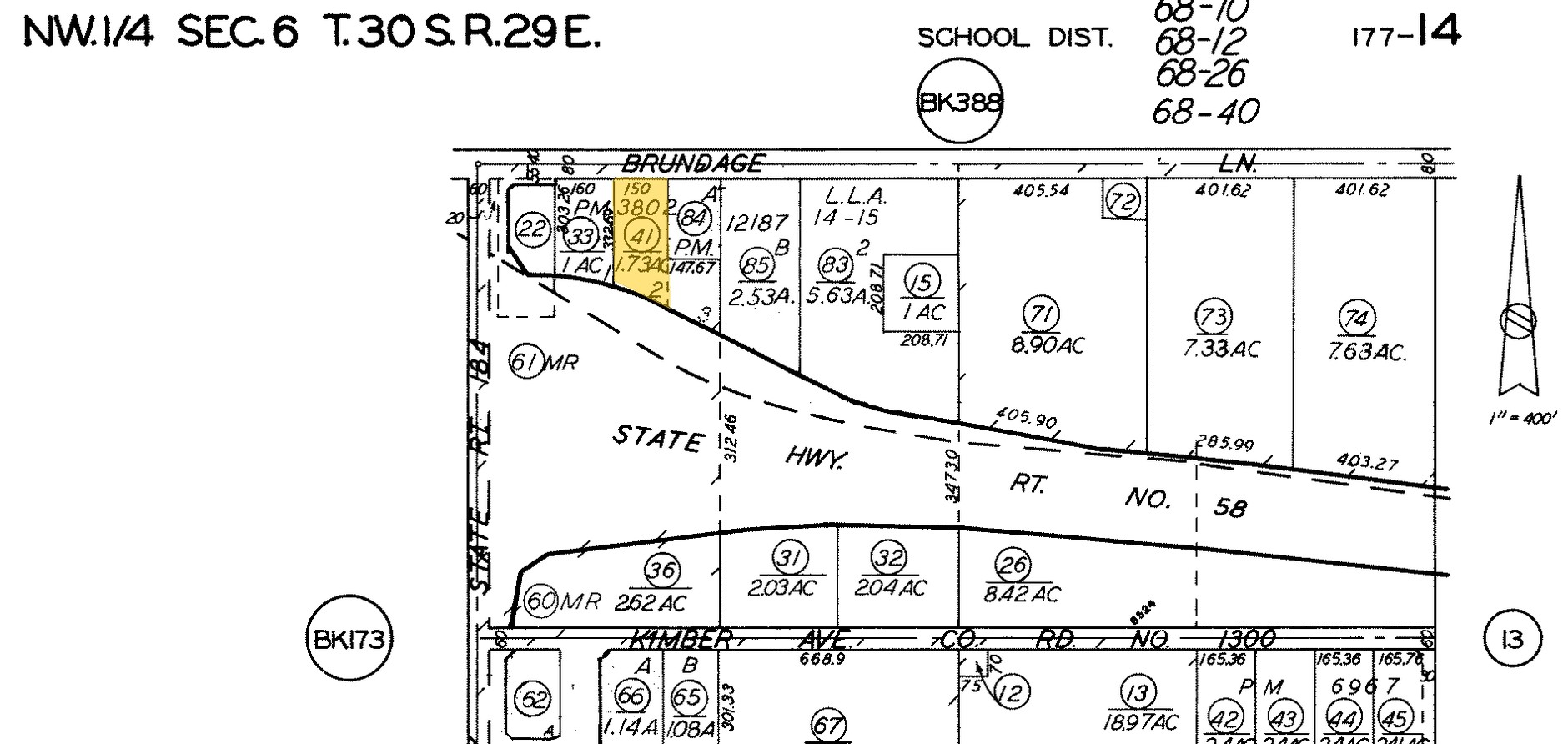
Property Record
8223 E Brundage Ln, Bakersfield, CA 93307
NEARBY LISTINGS FOR SALE OR LEASE
-
-
View all Bakersfield listings for sale on LoopNet.com
Property Detail
8223 E Brundage Ln
Bakersfield, CA
Parcel Map 3802
177-140-41-00-9
PARCEL MAP 3802 , LOT 2&PN
Motel
Kern
X
California
06029C2306E
2
2023
1.73 AC
2024
Bakersfield
001001
Bakersfield
27,962 SF
DEMOGRAPHICS near 8223 E Brundage Ln
1 Mile
3 Mile
5 Mile
2024 Total Population
4,808
54,019
138,841
2029 Population
4,760
54,028
138,751
Pop Growth 2024-2029
(1.00%)
+ 0.02%
(0.06%)
Average Age
33
33
33
2024 Total Households
1,286
14,649
40,031
HH Growth 2024-2029
(1.24%)
(0.03%)
(0.09%)
Median Household Inc
$47,923
$49,586
$46,364
Avg Household Size
3.60
3.60
3.30
2024 Avg HH Vehicles
2.00
2.00
2.00
Median Home Value
$231,089
$237,545
$245,998
Median Year Built
1987
1978
1973
Nearby Places
- Restaurants
- Banks
- Shops
- Fitness
- Groceries
PUBLIC TRANSPORTATION
COMMUTER RAIL
Bakersfield (San Joaquins - Amtrak)
DRIVE
WALK
Distance
Bakersfield (San Joaquins - Amtrak)
11 min
6.2 mi
AIRPORT
Meadows Field
DRIVE
WALK
Distance
Meadows Field
24 min
14.1 mi
Freight Ports
The Port of Hueneme
DRIVE
WALK
Distance
The Port of Hueneme
159 min
127.8 mi
Nearby Properties
Address
Land Use
TOTAL SIZE
Lot Size
Zoning
Address
Land Use
TOTAL SIZE
Lot Size
Zoning
18,000 SF
35.01 AC
M-2
Address
Land Use
TOTAL SIZE
Lot Size
Zoning
1.38 AC
C-2
Address
Land Use
TOTAL SIZE
Lot Size
Zoning
66,139 SF
4.48 AC
CO
Address
Land Use
TOTAL SIZE
Lot Size
Zoning
112,052 SF
3.14 AC
R3
Address
Land Use
TOTAL SIZE
Lot Size
Zoning
50,445 SF
2.53 AC
C2
Address
Land Use
TOTAL SIZE
Lot Size
Zoning
17,567 SF
19.39 AC
M2
Address
Land Use
TOTAL SIZE
Lot Size
Zoning
17.85 AC
M3
Address
Land Use
TOTAL SIZE
Lot Size
Zoning
66,582 SF
3.36 AC
R-2
Address
Land Use
TOTAL SIZE
Lot Size
Zoning
33,264 SF
28.68 AC
AG
Address
Land Use
TOTAL SIZE
Lot Size
Zoning
68,264 SF
6.56 AC
C2
Address
Land Use
TOTAL SIZE
Lot Size
Zoning
46,522 SF
3.35 AC
R2
Address
Land Use
TOTAL SIZE
Lot Size
Zoning
95,258 SF
5.34 AC
PUD
Address
Land Use
TOTAL SIZE
Lot Size
Zoning
9,627 SF
12.37 AC
C2
Address
Land Use
TOTAL SIZE
Lot Size
Zoning
93,070 SF
7.98 AC
PUD
Address
Land Use
TOTAL SIZE
Lot Size
Zoning
44,779 SF
2.17 AC
M2
Address
Land Use
TOTAL SIZE
Lot Size
Zoning
97,900 SF
6.98 AC
M-2 PD
Address
Land Use
TOTAL SIZE
Lot Size
Zoning
41,089 SF
5.96 AC
C-2 PD
Address
Land Use
TOTAL SIZE
Lot Size
Zoning
39,175 SF
12.21 AC
M2
Address
Land Use
TOTAL SIZE
Lot Size
Zoning
85,718 SF
4.72 AC
R-3
Address
Land Use
TOTAL SIZE
Lot Size
Zoning
47,592 SF
35.87 AC
M2
Address
Land Use
TOTAL SIZE
Lot Size
Zoning
12,124 SF
10.06 AC
M2
Address
Land Use
TOTAL SIZE
Lot Size
Zoning
26,295 SF
1.25 AC
R2
Address
Land Use
TOTAL SIZE
Lot Size
Zoning
944 SF
4.81 AC
E(1/2AC)RS
Address
Land Use
TOTAL SIZE
Lot Size
Zoning
113,326 SF
8.35 AC
R2
Address
Land Use
TOTAL SIZE
Lot Size
Zoning
246.66 AC
A
Address
Land Use
TOTAL SIZE
Lot Size
Zoning
398.60 AC
A
Address
Land Use
TOTAL SIZE
Lot Size
Zoning
74,135 SF
4.38 AC
M-2
Address
Land Use
TOTAL SIZE
Lot Size
Zoning
26,850 SF
2.50 AC
C-2
Address
Land Use
TOTAL SIZE
Lot Size
Zoning
30,000 SF
12.56 AC
M-1
The World's #1 Commercial Real Estate Marketplace
Connect with us
© 2025 CoStar Group
The information above has been obtained from sources believed reliable. While we do not doubt its accuracy we have not verified it and make no guarantee, warranty or representation about it. It is your responsibility to independently confirm its accuracy and completeness. Any projections, opinions, assumptions, or estimates used are for example only and do not represent the current or future performance of the property. The value of this transaction to you depends on tax and other factors which should be evaluated by your tax, financial, and legal advisors. You and your advisors should conduct a careful, independent investigation of the property to determine to your satisfaction the suitability of the property for your needs.