Property Record
8265 Euclid Chardon Rd, Kirtland, OH 44094

NEARBY LISTINGS FOR SALE OR LEASE
-
-
View all Kirtland listings for sale on LoopNet.com
Property Detail
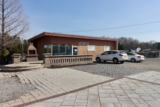
8265 Euclid Chardon Rd
20-A-029-A-00-066
LOT 91 TRACT 3
Storebuilding
Lake
X
Ohio
39085C0203F
91
2024
1.85 AC
2024
Northeast
206400
Cleveland
4,270 SF
Cleveland-Elyria, OH
DEMOGRAPHICS near 8265 Euclid Chardon Rd
1 Mile
3 Mile
5 Mile
2024 Total Population
1,594
10,809
34,389
2029 Population
1,578
10,764
34,489
Pop Growth 2024-2029
(1.00%)
(0.42%)
+ 0.29%
Average Age
44
45
46
2024 Total Households
582
4,174
14,623
HH Growth 2024-2029
(1.03%)
(0.46%)
+ 0.37%
Median Household Inc
$125,459
$112,023
$94,687
Avg Household Size
2.70
2.50
2.30
2024 Avg HH Vehicles
2.00
2.00
2.00
Median Home Value
$367,889
$341,553
$286,690
Median Year Built
1970
1971
1971
Nearby Places
Map Layers
Map Styles
 Street
 Aerial
- Restaurants
- Banks
- Shops
- Fitness
- Groceries
PUBLIC TRANSPORTATION
AIRPORT
Cleveland-Hopkins International
DRIVE
WALK
Distance
Cleveland-Hopkins International
53 min
35.4 mi
Freight Ports
Port of Toledo
DRIVE
WALK
Distance
Port of Toledo
167 min
135.8 mi
SALE & LEASE HISTORY
LISTING DATE
SALE/LEASE

Apr 13, 2023
For Sale
Nearby Properties
Address
Land Use
TOTAL SIZE
Lot Size
Zoning
Address
Land Use
TOTAL SIZE
Lot Size
Zoning
233,654 SF
26.21 AC
B-2
Address
Land Use
TOTAL SIZE
Lot Size
Zoning
89,942 SF
5.12 AC
B-2
Address
Land Use
TOTAL SIZE
Lot Size
Zoning
52,994 SF
15 AC
R3A
Address
Land Use
TOTAL SIZE
Lot Size
Zoning
13,764 SF
29.10 AC
R-3
Address
Land Use
TOTAL SIZE
Lot Size
Zoning
3,071 SF
28.79 AC
U-1
Address
Land Use
TOTAL SIZE
Lot Size
Zoning
21,709 SF
13.74 AC
Address
Land Use
TOTAL SIZE
Lot Size
Zoning
33,318 SF
14.42 AC
R-3
Address
Land Use
TOTAL SIZE
Lot Size
Zoning
11,350 SF
42.44 AC
R
Address
Land Use
TOTAL SIZE
Lot Size
Zoning
51,646 SF
119.14 AC
Address
Land Use
TOTAL SIZE
Lot Size
Zoning
77,435 SF
12.01 AC
Address
Land Use
TOTAL SIZE
Lot Size
Zoning
1,512 SF
45.05 AC
R-3
Address
Land Use
TOTAL SIZE
Lot Size
Zoning
15,600 SF
8.75 AC
I
Address
Land Use
TOTAL SIZE
Lot Size
Zoning
19,438 SF
162.54 AC
R-3
Address
Land Use
TOTAL SIZE
Lot Size
Zoning
3,520 SF
29.97 AC
R3A
Address
Land Use
TOTAL SIZE
Lot Size
Zoning
17,245 SF
14.44 AC
R
Address
Land Use
TOTAL SIZE
Lot Size
Zoning
6,274 SF
21.20 AC
R-3
Address
Land Use
TOTAL SIZE
Lot Size
Zoning
27,517 SF
7.42 AC
R
Address
Land Use
TOTAL SIZE
Lot Size
Zoning
14,409 SF
26.35 AC
Address
Land Use
TOTAL SIZE
Lot Size
Zoning
16,524 SF
15 AC
B-2
Address
Land Use
TOTAL SIZE
Lot Size
Zoning
4,008 SF
63.90 AC
R
Address
Land Use
TOTAL SIZE
Lot Size
Zoning
13,879 SF
15.84 AC
R-3
Address
Land Use
TOTAL SIZE
Lot Size
Zoning
14,898 SF
5 AC
B-2
Address
Land Use
TOTAL SIZE
Lot Size
Zoning
1,988 SF
145.89 AC
R-3
Address
Land Use
TOTAL SIZE
Lot Size
Zoning
Address
Land Use
TOTAL SIZE
Lot Size
Zoning
18,520 SF
7.11 AC
Address
Land Use
TOTAL SIZE
Lot Size
Zoning
5,130 SF
10.74 AC
R
Address
Land Use
TOTAL SIZE
Lot Size
Zoning
17,005 SF
9.02 AC
R-3
Address
Land Use
TOTAL SIZE
Lot Size
Zoning
192.03 AC
R5A
Address
Land Use
TOTAL SIZE
Lot Size
Zoning
25,318 SF
5.30 AC
B2
Address
Land Use
TOTAL SIZE
Lot Size
Zoning
4,137 SF
48.56 AC
R
The World's #1 Commercial Real Estate Marketplace
Connect with us
© 2025 CoStar Group
The information above has been obtained from sources believed reliable. While we do not doubt its accuracy we have not verified it and make no guarantee, warranty or representation about it. It is your responsibility to independently confirm its accuracy and completeness. Any projections, opinions, assumptions, or estimates used are for example only and do not represent the current or future performance of the property. The value of this transaction to you depends on tax and other factors which should be evaluated by your tax, financial, and legal advisors. You and your advisors should conduct a careful, independent investigation of the property to determine to your satisfaction the suitability of the property for your needs.