Property Record
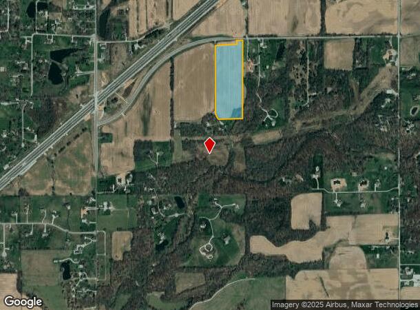
7885 N Whiteland Ln, Martinsville, IN 46151
NEARBY LISTINGS FOR SALE OR LEASE
Property Detail
7885 N Whiteland Ln
Indianapolis-Carmel-Anderson, IN
Korra
55-06-25-100-008.000-011
PT LOT 5 KORRA FINAL MINOR PLAT 15.11 A
Residentialacreage
Morgan
A
Indiana
18109C0170E
5
2023
15.11 AC
2024
Morgan County
510601
Indianapolis
1,554 SF
DEMOGRAPHICS near 7885 N Whiteland Ln
1 Mile
3 Mile
5 Mile
2024 Total Population
770
4,436
21,609
2029 Population
805
4,634
22,809
Pop Growth 2024-2029
+ 4.55%
+ 4.46%
+ 5.55%
Average Age
43
42
41
2024 Total Households
296
1,621
7,688
HH Growth 2024-2029
+ 4.73%
+ 4.38%
+ 5.55%
Median Household Inc
$81,473
$85,833
$97,732
Avg Household Size
2.60
2.70
2.80
2024 Avg HH Vehicles
3.00
3.00
3.00
Median Home Value
$197,618
$277,963
$324,531
Median Year Built
1990
1989
1991
Nearby Places
- Restaurants
- Banks
- Shops
- Fitness
- Groceries
PUBLIC TRANSPORTATION
AIRPORT
Indianapolis International
DRIVE
WALK
Distance
Indianapolis International
37 min
20.8 mi
Freight Ports
Port of Toledo
DRIVE
WALK
Distance
Port of Toledo
299 min
247.4 mi
Nearby Properties
Address
Land Use
TOTAL SIZE
Lot Size
Zoning
Address
Land Use
TOTAL SIZE
Lot Size
Zoning
14,909 SF
15.98 AC
Address
Land Use
TOTAL SIZE
Lot Size
Zoning
8,241 SF
21.87 AC
R5
Address
Land Use
TOTAL SIZE
Lot Size
Zoning
14,266 SF
78 AC
Address
Land Use
TOTAL SIZE
Lot Size
Zoning
24,360 SF
12.86 AC
R1
Address
Land Use
TOTAL SIZE
Lot Size
Zoning
7,338 SF
5.07 AC
Address
Land Use
TOTAL SIZE
Lot Size
Zoning
19,264 SF
1.85 AC
Address
Land Use
TOTAL SIZE
Lot Size
Zoning
7,604 SF
3.02 AC
Address
Land Use
TOTAL SIZE
Lot Size
Zoning
4,313 SF
1.45 AC
Address
Land Use
TOTAL SIZE
Lot Size
Zoning
31,912 SF
3.84 AC
Address
Land Use
TOTAL SIZE
Lot Size
Zoning
4,014 SF
7.13 AC
Address
Land Use
TOTAL SIZE
Lot Size
Zoning
3,822 SF
6.60 AC
Address
Land Use
TOTAL SIZE
Lot Size
Zoning
2,514 SF
14.09 AC
R1
Address
Land Use
TOTAL SIZE
Lot Size
Zoning
2,626 SF
0.94 AC
Address
Land Use
TOTAL SIZE
Lot Size
Zoning
4,338 SF
0.53 AC
Address
Land Use
TOTAL SIZE
Lot Size
Zoning
6,750 SF
1.63 AC
B2
Address
Land Use
TOTAL SIZE
Lot Size
Zoning
3,230 SF
2.60 AC
Address
Land Use
TOTAL SIZE
Lot Size
Zoning
Address
Land Use
TOTAL SIZE
Lot Size
Zoning
19,811 SF
5 AC
Address
Land Use
TOTAL SIZE
Lot Size
Zoning
4,516 SF
0.74 AC
B2
Address
Land Use
TOTAL SIZE
Lot Size
Zoning
1,942 SF
202.04 AC
Address
Land Use
TOTAL SIZE
Lot Size
Zoning
266.78 AC
Address
Land Use
TOTAL SIZE
Lot Size
Zoning
2,642 SF
9.13 AC
Address
Land Use
TOTAL SIZE
Lot Size
Zoning
16,008 SF
1 AC
Address
Land Use
TOTAL SIZE
Lot Size
Zoning
17.87 AC
Address
Land Use
TOTAL SIZE
Lot Size
Zoning
Address
Land Use
TOTAL SIZE
Lot Size
Zoning
5,040 SF
1.52 AC
Address
Land Use
TOTAL SIZE
Lot Size
Zoning
5.07 AC
Address
Land Use
TOTAL SIZE
Lot Size
Zoning
232.67 AC
Address
Land Use
TOTAL SIZE
Lot Size
Zoning
920 SF
9.70 AC
Address
Land Use
TOTAL SIZE
Lot Size
Zoning
6,235 SF
1.05 AC
The World's #1 Commercial Real Estate Marketplace
Connect with us
© 2025 CoStar Group
The information above has been obtained from sources believed reliable. While we do not doubt its accuracy we have not verified it and make no guarantee, warranty or representation about it. It is your responsibility to independently confirm its accuracy and completeness. Any projections, opinions, assumptions, or estimates used are for example only and do not represent the current or future performance of the property. The value of this transaction to you depends on tax and other factors which should be evaluated by your tax, financial, and legal advisors. You and your advisors should conduct a careful, independent investigation of the property to determine to your satisfaction the suitability of the property for your needs.