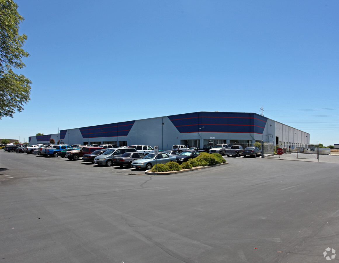
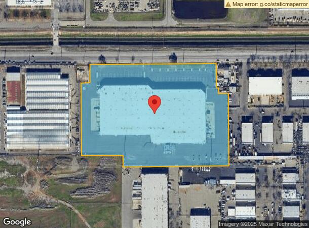
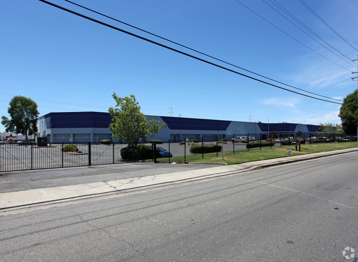
Property Record
8360 Elder Creek Rd, Sacramento, CA 95828

NEARBY LISTINGS FOR SALE OR LEASE
Property Detail
8360 Elder Creek Rd
064-0010-078
Oates Industrial Park
Shipyard
PCL 1, PCL MAP BK 105, PG 29, EXC THE E 11.43 FT OF THE N147 FT. CONTG 11.837 N AC M/L
X
Sacramento
06067C0195H
California
2023
11.84 AC
2024
Power Inn
009201
Sacramento
196,267 SF
Sacramento--Roseville--Arden-Arcade, CA
DEMOGRAPHICS near 8360 Elder Creek Rd
1 Mile
3 Mile
5 Mile
2024 Total Population
2,896
110,183
374,756
2029 Population
2,907
110,855
377,401
Pop Growth 2024-2029
+ 0.38%
+ 0.61%
+ 0.71%
Average Age
37
37
37
2024 Total Households
778
34,873
123,878
HH Growth 2024-2029
+ 0.13%
+ 0.62%
+ 0.74%
Median Household Inc
$49,184
$58,296
$68,396
Avg Household Size
3.40
3.00
2.90
2024 Avg HH Vehicles
2.00
2.00
2.00
Median Home Value
$374,056
$347,473
$400,092
Median Year Built
1974
1976
1977
Nearby Places
- Restaurants
- Banks
- Shops
- Fitness
- Groceries
PUBLIC TRANSPORTATION
AIRPORT
Sacramento International
DRIVE
WALK
Distance
Sacramento International
31 min
21.0 mi
Freight Ports
Port of Stockton
DRIVE
WALK
Distance
Port of Stockton
59 min
47.2 mi
Nearby Properties
Address
Land Use
TOTAL SIZE
Lot Size
Zoning
Address
Land Use
TOTAL SIZE
Lot Size
Zoning
2,317,288 SF
220.58 AC
M-2-SPD
Address
Land Use
TOTAL SIZE
Lot Size
Zoning
350,049 SF
8.51 AC
MRD-SWR
Address
Land Use
TOTAL SIZE
Lot Size
Zoning
45.93 AC
M-2S
Address
Land Use
TOTAL SIZE
Lot Size
Zoning
149,566 SF
9.68 AC
M-2S
Address
Land Use
TOTAL SIZE
Lot Size
Zoning
281,448 SF
13.42 AC
RMX-TO R-2
Address
Land Use
TOTAL SIZE
Lot Size
Zoning
40.67 AC
M-2-SPD
Address
Land Use
TOTAL SIZE
Lot Size
Zoning
187,080 SF
10.01 AC
SPA
Address
Land Use
TOTAL SIZE
Lot Size
Zoning
119,380 SF
18.92 AC
M-2S
Address
Land Use
TOTAL SIZE
Lot Size
Zoning
584,820 SF
29.12 AC
M-2S
Address
Land Use
TOTAL SIZE
Lot Size
Zoning
345,600 SF
14.84 AC
M-1S-SWR
Address
Land Use
TOTAL SIZE
Lot Size
Zoning
281,404 SF
21.43 AC
M-2
Address
Land Use
TOTAL SIZE
Lot Size
Zoning
164,981 SF
3.95 AC
OB-SWR-PUD
Address
Land Use
TOTAL SIZE
Lot Size
Zoning
198,112 SF
19.62 AC
M-1 M-1 (N
Address
Land Use
TOTAL SIZE
Lot Size
Zoning
0.12 AC
SPA
Address
Land Use
TOTAL SIZE
Lot Size
Zoning
261,350 SF
14.41 AC
M-2S
Address
Land Use
TOTAL SIZE
Lot Size
Zoning
213,445 SF
18.25 AC
SC
Address
Land Use
TOTAL SIZE
Lot Size
Zoning
158,710 SF
14.02 AC
M-1
Address
Land Use
TOTAL SIZE
Lot Size
Zoning
271,016 SF
15.54 AC
R-2B-PUD
Address
Land Use
TOTAL SIZE
Lot Size
Zoning
138,779 SF
44.77 AC
M-2S
Address
Land Use
TOTAL SIZE
Lot Size
Zoning
120,868 SF
53.03 AC
SPA
Address
Land Use
TOTAL SIZE
Lot Size
Zoning
319,485 SF
16.35 AC
M-2S
Address
Land Use
TOTAL SIZE
Lot Size
Zoning
Address
Land Use
TOTAL SIZE
Lot Size
Zoning
133,620 SF
11.71 AC
C-2-SPD
Address
Land Use
TOTAL SIZE
Lot Size
Zoning
55,344 SF
4.75 AC
M-2S
Address
Land Use
TOTAL SIZE
Lot Size
Zoning
150,652 SF
4.10 AC
OB-SWR-PUD
Address
Land Use
TOTAL SIZE
Lot Size
Zoning
12.04 AC
M-1S-R
Address
Land Use
TOTAL SIZE
Lot Size
Zoning
161,834 SF
15.23 AC
LC
Address
Land Use
TOTAL SIZE
Lot Size
Zoning
162,920 SF
5.53 AC
OB-SWR-PUD
Address
Land Use
TOTAL SIZE
Lot Size
Zoning
5.29 AC
M-2S
Address
Land Use
TOTAL SIZE
Lot Size
Zoning
2.19 AC
M-1
The World's #1 Commercial Real Estate Marketplace
Connect with us
© 2025 CoStar Group
The information above has been obtained from sources believed reliable. While we do not doubt its accuracy we have not verified it and make no guarantee, warranty or representation about it. It is your responsibility to independently confirm its accuracy and completeness. Any projections, opinions, assumptions, or estimates used are for example only and do not represent the current or future performance of the property. The value of this transaction to you depends on tax and other factors which should be evaluated by your tax, financial, and legal advisors. You and your advisors should conduct a careful, independent investigation of the property to determine to your satisfaction the suitability of the property for your needs.